
What makes the best 360 surveying camera to capture data for GIS infrastructure surveying? GPS, a 360 waterproof camera, and HD resolution.
What is GIS surveying?
A geographical information system (GIS) is a general term for “surveying” and other systems of capturing, measuring and locating data and objects on the earth. It is a software built on a database, rather than multiple systems or files, which allows the end users to work with data related to the layout of many forms of infrastructure including roads, buildings, railways, tunnels, bridges, water supply, and telecommunications. All of this data is presented in its geographical area, analyzing its spatial information in respect to distance, area, zones and addresses, to name a few.
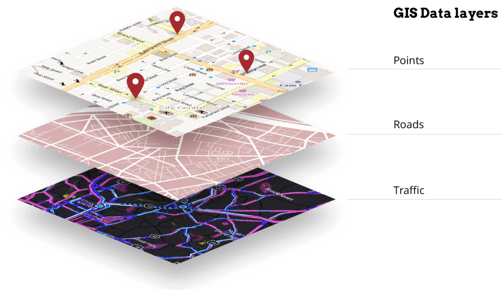
GIS is, at its core, a map of various layers, each one presenting its own slice of information, focused on one particular feature or aspect of a geographical location. Layers can be added or removed in order to gain a more accurate comprehension of a query about the location in question.
Maps are an essential way in which we as humans can understand the enormous amount of data that is available at our fingertips. They allow us to visualize patterns and relationships, as well as analyze conditions of a given area. This is especially true in infrastructure surveying and maintenance.
What is the use of GIS in infrastructure surveying and maintenance?
So how does GIS surveying aid in infrastructure construction and maintenance? By providing a wide array of data that can give us a better interpretation of the world around us, from a unique perspective.
Present particular features located on a map
While you might think that this is exactly what popular public maps such as Google maps can do, you would be slightly mistaken. Google maps can give us all of the information of a particular geographical region, including rivers, lakes, roads and buildings, but it cannot allow us to look at one particular feature as a stand alone data set. It can present a map of only one particular geographical feature or characteristic such as rivers, buildings, or traffic lights within a given zone.
Present the quantities of a feature in a parcel
Surveying infrastructure means counting and creating an inventory of features within the parcel of land. This could be things like street signs, bus stops, schools, cemeteries, trees, cracks in roads or pavement, and more. GIS allows the end user, such as construction companies, road maintenance companies and government agencies, to see what structures are there, what are missing and what are in need of repair.

Present population densities
When designing, building, or updating infrastructure, it is important to know the population density of a neighborhood, town, or city in order to determine if there are enough stop signs, speed limit signs, or barriers to maintain the flow of traffic and keep pedestrians and drivers safe on the roads. By knowing the quantity of foot and vehicle traffic in any one area, organizations are able to determine the population density down to the city block.
Present driving times
By properly mapping the road systems and understanding traffic flow, it is possible to create a “routing table” which allows the creation of optimum routes from one location to another (i.e. driving directions). GIS data can offer vital information about the fastest and most direct routes for emergency response vehicles to take during certain times of day and during different traffic conditions. It can also show the span of distance that can be covered from point A within a given time frame, allowing law enforcement to determine the area that a kidnapping suspect may have gotten.
Present the prevalence of utility poles
Utility poles play a crucial role in the overall functioning of many services such as electrical cables, fiber optic cables, and related equipment such as transformers and street lights. Without utility poles, the services would be unavailable to most of the world’s population. Therefore, the maintenance of them is essential. But given the vast number of them and their locations, from inner cities to lonely country sides, it is difficult to maintain a constant eye on them. GIS mapping can identify utility poles, give their locations and their conditions so that the proper authorities can make the necessary repairs.
What are the advantages of using GIS infrastructure surveying?
Surveying an area of land is important for many steps along the way in infrastructure planning, building, and maintenance. It is an effective and efficient way to prepare for, steer clear of, and prevent potential problems that arise in infrastructure related projects such as constructing a new highway, laying down piping or new high speed internet / fiber optic cables, or checking on the conditions of a current site or street within a city.
Benefits include:
- Identifying and surveying underground services prior to the commencement of a project
- Reducing costs by reducing the need for unnecessary visits to a site
- Accurately calculating a budget and schedule for a project
- Precisely identifying potential risks, challenges or slowdowns for better time management of a project
- Increasing efficiency by supplying all of the necessary data in one database, rather than multiple files and platforms as was historically the case.
- Remotely accessing information
- Improving the decision making process by making it possible to compare information about multiple locations
- Providing data in an understandable way for all those involved in all phases of infrastructure life cycle and improving communication
How is GIS mapping done? How is data captured and collected?
There are two primary ways in which private companies, public organizations, and government agencies actually capture and collect the necessary data to be analyzed by a GIS.
On-site GIS surveying
The first such method used to capture data for GIS infrastructure surveying purposes is through a traditional on-site survey. This has been the most common method for centuries, and it has seen gradual innovations and improvements in techniques and technology over the last few decades. However, there are still many disadvantages to such a method of data capturing.
This customary system of collecting data involves a significant source of manpower, planning, paperwork, and possible disturbance of vehicle and/or pedestrian traffic if it is necessary to cordon off an area to allow surveyors to safely work. Surveyors must conduct all measurements on-site and manually enter a great deal of data in order that the GIS has sufficient and accurate data to provide the answers that are asked of it.
Conventional surveying also only captures a moment in time, meaning that the information collected is only 100% verifiable at the time of the survey and could generate additional costs and issues down the road as features of the site change throughout the construction or maintenance of that location.
Mobile GIS Surveying
Due to the many drawbacks of such a system of capturing data, state-of-the-art technologies have been designed to eliminate these pain points. They revolve around the combination of radar and sensors which can capture data in a more accurate, time sensitive and less costly way.
One of the standouts in the field of data capture, is the use of a 360 surveying camera, such as the Mosaic 51. This camera was designed and crafted with GIS surveying and mobile surveying in mind. Situated on the top of a moving vehicle, it is able to gather data at all 360-degrees with extreme accuracy and definition.

The Mosaic 51 will consist of two parts: a rooftop camera and a dashcam. The rooftop camera is utilized for the preliminary surveying of a given area. Once the initial survey is completed, follow ups can be conducted and the data refreshed with the use of dashcams, situated on a whole host of vehicles. This means that the GIS will stay up to date on the latest changes in the site and will know if any of the features (traffic signs, construction zones or the grade of the road) have been altered since the last pass with the 360 HD camera. No need for repeated on-site visits which can add time and money to any project.
Mobile surveying means that the surveying process can be done from the comfort of a vehicle, with only a single driver on board. It also means that it is not necessary to hinder, divert or interrupt traffic in order to conduct the survey, greatly cutting down on the process itself.
Top Technical Features of a GIS Surveying Camera
With its waterproof industrial-grade connector, a rating of IP64 water and dust resistance, the Mosaic 51 will not be put off by rain, snow or windy conditions and can survey an area in any time of extreme condition. It is the only waterproof 360 camera with such a robust rating and durability.
The camera’s resolution is 12K, making it the top in the field of 360-degree cameras. The fact that it is a 360 HD camera means that all of the information captured is of the highest quality resolution available. Better resolution means greater insight for the end user, as details such as whether bus stop schedules are updated or a crack in the road has become a hazardous pothole will allow them to make quicker, more informed decisions and help them react quicker to situations which need attention.
The Mosaic 51 can also capture 12-bit compressed RAW images meaning that a very high level of quality of data can be captured, collected and stored on the camera during the surveying process.
And last but certainly not least, GPS (Global Positioning System) is of the utmost importance as well, since GIS would be nothing without the geographical coordinates to create a map. The Mosaic 51 comes with a built-in GPS and IMU and with the use of the auxiliary port you can connect many other forms of GNSS sensors for centimeter level accuracy.
Summing it all up
GIS surveying has already shown to be an incredibly useful and vital tool for businesses and governments, even reaching into the private lives of everyday citizens. Infrastructure projects and maintenance works touch all of our lives on a daily basis.
This powerful tool has the potential to grow even more, expanding our knowledge of the world around us and broadening our understanding of the communities, networks and systems we function within.
In order for that to occur, advanced technology and AI must be utilized to capture and collect the available data from our environment. Moving forward, more and more companies and organizations will be shifting towards these advanced technologies, and the Mosaic 51 will be right alongside them.
To find out more about what the Mosaic 51 camera can do, contact the team for the details of the latest and greatest 360-degree camera and learn about the incredible features taking GIS infrastructure surveying to a whole new level.
