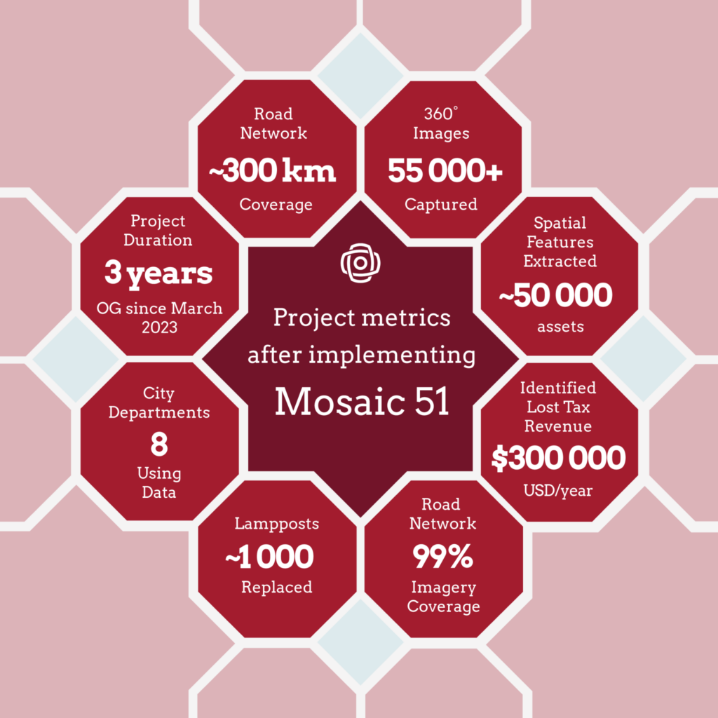
Developing countries have unique cadastral mapping challenges that 360° street-view imagery can mitigate. Today, we head to Morocco to see how the city of Dakhla saw an immediate ROI with two Mosaic 51 mobile mapping cameras.
Urban environments are a collage of the millions of tiny choices made by local customs and infrastructure laws.
Behind every sidewalk, streetlight, and road sign are layers of influences that determine the finest details in our built environment. Something that looks simple on the surface, such as a zoning law about the width of a sidewalk or the color of a road sign, can be the difference between a pleasant or dangerous urban experience.
The policymakers and technical experts making these behind-the-scenes decisions need accurate information about current road and building conditions. However, traditional surveying methods are slow, expensive, and even dangerous.
Traditional surveying often requires sending workers out into the streets alongside heavy traffic. It can also take months to capture all the visual data needed to create a comprehensive visual representation of a city.
To maintain order and ensure that codes are enforced in a timely and affordable manner, governments in developing countries have to get creative. In Dakhla, Morocco, that meant purchasing their first Mosaic 51 mobile mapping system in 2022.
Since their initial purchase, the Mosaic 51 has become the backbone of a comprehensive urban digital transformation initiative. About six months after purchasing their first Mosaic 51, Dakhla bought a second unit to keep up with multiple departments’ demands for 360° imagery. The project demonstrates a compelling real-world use case that showcases the camera’s capabilities in municipal governance, infrastructure management, and fiscal operations.
Code enforcement issues specific to developing countries
Developed countries tend to have well-established, strong institutions and efficient workflows to maintain control of city streets, but in developing countries, many challenges stand in the way of success.
There may be little public trust in the institutions set up to enforce public safety laws. Code enforcement and public safety also go hand in hand with attracting international financial interest. For smaller cities that are not already established hubs for tourism and business, it is challenging to build the scaffolding needed to ensure trust.
However, there is one such area in which developing countries have an advantage over developed countries.
Technological Leapfrogging
Technological leapfrogging is when a developing country bypasses the intermediate stages in the development process. With this tool, they can jump straight from an older technology to the newest one, almost defying evolution.
Although the up-front costs of making a technological leap seem high, they are often much lower than the cost of moving through every preceding stage.
We’ve seen this already worldwide with mobile telecommunications. Instead of building landline infrastructure, just to eventually upgrade to cellphones, many developing countries have skipped landline investments altogether.
Technological leapfrogging makes “arriving late to the party” much easier.
In Dakhla, Morocco, leapfrogging looks like mapping the city streets in 360° with high-resolution imagery. Despite their limited workforce and financial resources, the city was able to build a comprehensive cadastral map by bypassing many time-consuming, expensive traditional mapping methods.
Dakhla: a growing African city
Dakhla is located on a peninsula of Southern Morocco that juts out into the Atlantic Ocean. It is gaining popularity among international windsurfing and kitesurfing communities for its year-round stable temperatures and its fairly shallow lagoons.
Tourism and fishing are its main industries, and the city is growing rapidly. Its population doubled from around 55,000 to approximately 110,000 between 2004 and 2014, and is expected to double again by 2030.
Such rapid growth and new international attention mean local authorities face growing demands on infrastructure and their police force. With very little historical data available and a small workforce, Dakhla’s administrative police struggled to keep up with citizen complaints, enforcement of authorizations, and administrative matters.
Before implementing the Mosaic 51 solution, the municipality faced these significant challenges:
- Limited data on urban assets and infrastructure across the city
- A small administrative police department stretched thin across a large geographic area
- Manual field visits were required for every enforcement action, authorization check, and citizen complaint
- No systematic way to monitor public space usage, commercial compliance, or infrastructure conditions
- Difficulty keeping pace with rapid urban development and expansion
Growing Pains
To discuss Dakhla’s challenges, we spoke with Hamdi Sghiyer, a Technical Field Officer with Dakhla’s administrative police. He works in both law enforcement and citizen services as part of the force’s efforts to modernize city management.
Sghiyer and his team work to ensure the proper use of public spaces. This role takes on several responsibilities, such as making sure code and building permits are respected and that shared city assets are well-maintained. “Our department’s work touches every corner of Dakhla. But we’re small, and getting from place to place eats up time and resources,” says Sghiyer. With limited capacity and a rapidly expanding city, Dakhla’s administrative police needed a way to survey and manage the urban environment more efficiently.
Through Geomatic, a local Esri partner, Sghiyer’s team discovered Mapersive, ArcGIS, and the Mosaic 51 mobile mapping camera. The Mosaic 51’s non-vendor-locked camera data and easy, flexible integration options were exactly what a local government with a limited budget needed in a camera.
The Solution
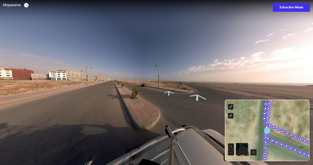
After purchasing their first Mosaic 51 camera, the city started strong with a full visual survey of Dakhla. While working with Geomatic, Dakhla deployed the Mosaic 51 camera system integrated with the Mapersive platform and the ArcGIS ecosystem. High-resolution imagery captured the city streets quickly and accurately for later analysis online in surveyors’ offices.
The solution enabled:
- Comprehensive 360° imagery capture of the entire urban road network
- AI-assisted extraction of 50,000+ spatial features, including lamp posts, businesses, signage, and infrastructure
- Integration with ArcGIS Online, ArcGIS Pro, Dashboards, and Survey123 for department-specific workflows
- Remote monitoring and enforcement without physical site visits
- Year-to-year change analysis to track urban development
This meant detailed, panoramic images of Dakhla’s streets came to life on surveyors’ computers. Infrastructure such as road markings, sidewalks, utility poles, and street signs used to require going out into the field, but now professionals can examine them quickly and comfortably.
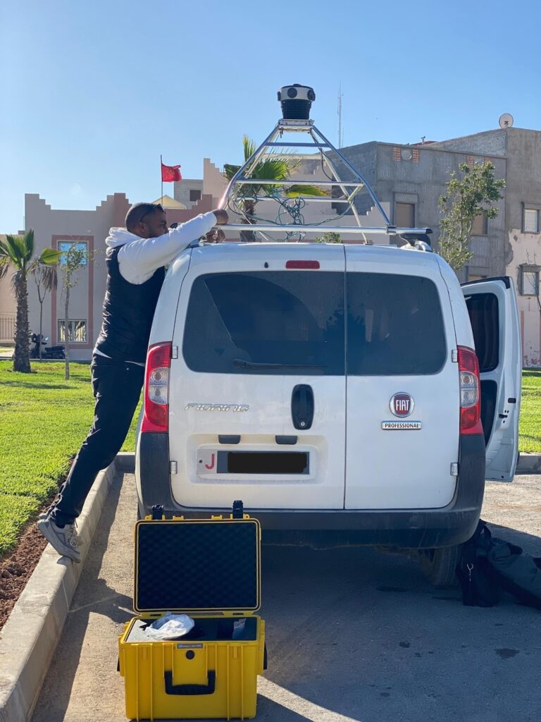
“Geomatic helped us get up to speed with the Mosaic 51 camera. We were trained on how to use the system, and learned a lot by going out in the field and capturing data ourselves.”
-Hamdi Sghiyer, Technical Field Officer
And the benefits don’t stop at convenience for government office workers. With its continuing growth, and the purchase of a second Mosaic 51 camera, having reliable, up-to-date visuals of the city streets helps the Dakhla administrative police plan and respond better to its citizens’ requests.
Dakhla’s technical workflow
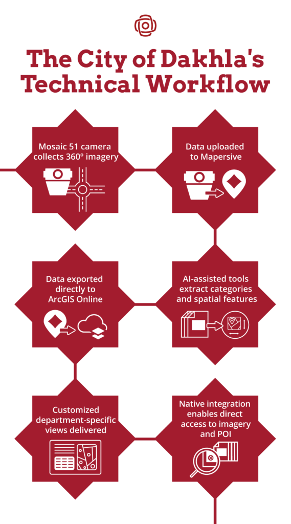
The Dakhla implementation follows a streamlined data pipeline:
- Mosaic 51 captures 12.3K resolution 360° imagery across the urban road network
- Imagery is uploaded to Mapersive for processing and 3D point cloud generation
- Geomatic extracts and categorizes spatial features using Mapersive’s AI-assisted tools
- Data is exported to ArcGIS Online directly from Mapersive into linked feature layers
- Custom ArcGIS Dashboards and web apps deliver department-specific views
- Mapersive’s native ArcGIS Online integration enables direct access to immersive imagery and screen caps of objects-of-interest
Two cameras for eight departments
For city governments in developing countries, it is important for any investment to return its value across multiple stakeholders. In Dakhla, their two Mosaic 51 mobile mapping systems has done exactly that. The Mosaic 51 camera’s usefulness has quickly spread beyond the administrative police department.
“The camera turned heads everywhere we went! The general feedback about the things the camera enabled for us was very positive across the departments. The high fidelity of the images was very appreciated and allowed us to really zoom into details like street numbers and coffee shop names. This is very important for matching anything we find in the images with our own internal records.”
– Sghiyer
Now, other government departments have also found ways to work with the 360° imagery. They can submit image requests, and then the administrative police conduct targeted drives with one of the Mosaic 51s.
Eight city departments now rely on Mosaic-captured imagery and Mapersive-extracted data for daily operations:
- Taxation and Accounting
- Street Lighting
- Administrative Police
- Urbanization
- Sanitation
- Parks and Recreation
- Health and Hygiene
- Public Works
Impact and Results
One of the most immediate benefits for the administrative police has been remote code enforcement. Code enforcement typically encompasses the parts of the law that are not criminal in nature, but keep the city running smoothly for everyone. Monitoring and enforcing municipal laws include checking that businesses are located where they are registered and ensuring that sidewalks and roads are clear of debris.
“We can now monitor the use of public spaces and commercial authorizations without needing to be on-site. We even use the images to measure how much space is occupied, which helps the taxation department estimate revenue.”
– Sghiyer
This level of cadastral detail, all the way down to seeing shop names and street numbers, was never possible before Dakhla adopted the Mosaic 51. Having immediate access to street-view data means the administrative police can act more quickly and precisely. This is resulting in fewer complaints from citizens and increased tax revenue due to up-to-date information.
Financial impact: $300,000 of tax revenue found per year
The accounting department used imagery data to model tax revenue predictions for public property usage and commercial advertisement. They identified approximately 2.7 million Moroccan Dirhams (close to $300,000 USD) in annual lost tax revenue due to non-compliant commercial establishments, including the entities that were out of compliance and where they were located.
Infrastructure improvements: nearly 1,000 lampposts
The street lighting department identified and replaced close to 1,000 lampposts using photographic evidence from Mosaic imagery. When a recently constructed city-wide sewage system caused widespread road damage, 360° imagery was used to systematically identify and document damage patches across the road network, enabling efficient repair prioritization.
Operational efficiency: fewer field visits
The administrative police can now monitor the occupancy of public spaces and verify commercial authorizations remotely, without traveling across the city. Using Mapersive’s measurement tools, they can calculate occupancy areas directly from the imagery.
Specific Use Cases
In short, the specific use cases across the eight city departments include:
- Illegal Construction Detection: Remote identification of unauthorized buildings and settlements
- Building Code Enforcement: Verification of compliance without site visits
- Public Property Encroachment: Monitoring commercial use of public space and sidewalks
- Signage Maintenance: Tracking the condition and compliance of commercial signage
- Street Lighting Management: Inventory and condition assessment of lampposts
- Year-to-Year Change Analysis: Comparative analysis of urban development over time
- Tax Revenue Recovery: Identification of non-compliant taxable activities
Looking Forward
With Dakhla planning to nearly double in size by 2030, the Mosaic 51 camera system is essential infrastructure for the city’s sustainable growth. The imagery survey process now runs multiple times per year, with continuous updates as the city develops. Discussions are ongoing regarding the program’s expansion.
For Hamdi Sghiyer, the Mosaic 51 has transformed his job, as well as his city:
“We now have a head start on the new developments happening across Dakhla, and it’s a relief to know that we will be able to keep up with the city’s rapid expansion in terms of data, enforcement, and citizen complaints. We’re now able to react more quickly to public disorder, illegal buildings, and settlements. This is a major improvement for the government-business-citizen relationship, especially as the city works to attract more tourism and international investment.”