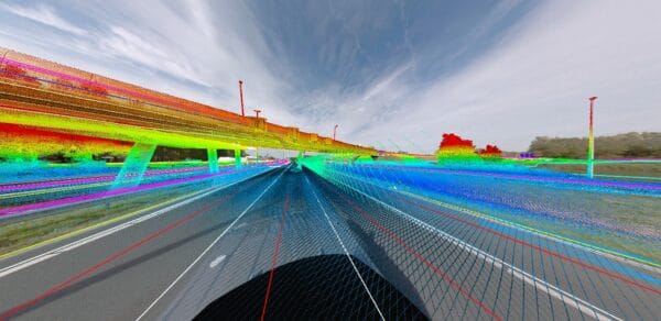
engineering and architecture 01

Engineering and Architecture

Mosaic's reliable 360° cameras provide real-time data for informed decisions and project success

Client testimonials

Why choose Mosaic for engineering and architecture?

several cranes above the buildings

Construction planning and research

Engineering firms must consider a lot of environmental factors at construction sites. Powerlines, water systems, and neighboring buildings can greatly impact the planning of a new structure. Without needing to visit the site, which may be remote, engineers and architects can draw up plans based on the surveying capabilities of Mosaic’s 360° cameras for engineering firms.

Capturing the “zero situation” – the verified condition of a site before any work begins – gives engineering teams an accurate baseline to plan against, and a defensible record of pre-existing conditions that protects all parties throughout the project.

Maintain accurate 3D models and digital twins of assets for clarity and efficiency, with imagery that integrates directly into CAD workflows and LiDAR point cloud processing. Enhanced planning and informed design mean overall financial savings.

blue and black high rise building

Digital twins of entire urban environments for planning and accessibility

Engineering and architecture firms are increasingly asked to work not just on individual structures but on entire urban environments – streets, neighborhoods, heritage areas, and public spaces that require detailed spatial understanding before any design or intervention can begin.

Mosaic camera systems make it practical to capture navigable digital twins of large-scale built environments quickly and efficiently, including areas inaccessible to standard survey vehicles. The resulting imagery provides architects, urban planners, and engineering teams with a ground-level, 360° representation of the environment as it actually exists – its buildings, streetscapes, access routes, and spatial relationships – that can be revisited repeatedly from the office as the design process evolves. 

This kind of comprehensive environmental baseline supports not only design and planning decisions but also accessibility assessments, heritage documentation, and stakeholder engagement, giving all parties a shared, accurate picture of the context they are working within.

white and gray dumpy level

Progress monitoring

Monitor everything from HD images of work quality to exact geographical coordinates with centimeter-level precision.

Rather than sending out a comprehensive team of engineers and quality assurance officers throughout a lengthy construction project that may last several years, Mosaic 360° camera systems for engineering firms can provide the same information at a much reduced cost and from a more convenient environment.
For projects on live highways and active infrastructure, operational reliability matters as much as image quality – Mosaic cameras are built to perform consistently in demanding conditions, with no downtime interrupting critical capture windows. Accurately monitor and take measurements of the roadways, railways, building constructions, or public works projects that are currently underway, and capture verified as-built documentation at completion – all without stopping traffic or setting up a surveying site.

Videos: See Mosaic systems in action

Real-Life Stories: How Mosaic's mobile mapping solutions deliver reliable data for project success

Get real-time data and stay current with 360° cameras for engineering and architecture firms. Design with constantly up-to-date information and monitor construction sites remotely. Stay on time and on budget.