
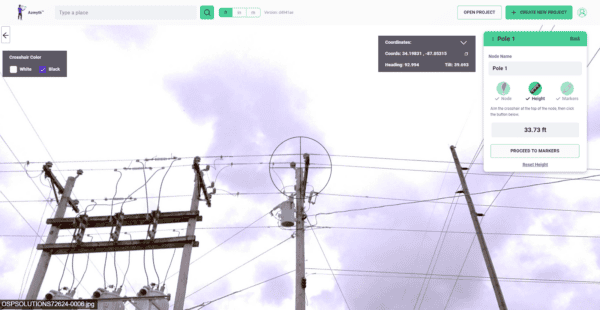
Transforming Utility Pole Inspections with Mosaic X Camera System
Learn how high-resolution 360° imagery, paired with Vulcan’s Azmyth platform, slashes costs by 70% and speeds up project timelines, setting new standards in the industry.

Capture highly accurate digital data sets to maintain the flow of information

When a telecom company is surveying a region to install fiber or expand its network, the traditional approach – sending surveyors to manually assess every pole and route on foot – is slow, expensive, and impossible to scale at pace.
A Mosaic camera mounted on a standard vehicle enables cost-effective telecom surveys across entire regions in a fraction of the time, capturing the high-resolution, georeferenced imagery that feeds directly into telecom mapping software and GIS for telecommunications utilities. The result is faster project timelines, lower survey costs, and the ability to survey multiple areas simultaneously without proportionally growing your field team.

When planning a fiber installation, the quality of your survey data directly determines the quality of your deployment decisions – which poles can carry additional cable, where underground routing is viable, how to minimize dig costs and maximize the number of properties connected.
High-resolution 360° imagery from Mosaic camera systems enables telecom photogrammetry and utility pole data collection for telecom from the office, allowing engineers to measure available space on poles, assess overhead and underground routing options, and design optimal installation paths without site visits. This ground-truth approach to network planning translates directly into more properties connected, shorter dig lengths, and lower overall deployment costs.

Maintaining telecommunications infrastructure – whether a telecom company is surveying for new assets or managing an existing network – requires staying current on the condition of every pole, cable, and junction across potentially thousands of kilometers.
Mosaic cameras make it practical to capture telecommunications reality capture data regularly across an entire network, enabling remote processing of utility pole data and ongoing asset inspection without repeated field deployments. Because the imagery is open-format and integrates with the GIS and asset management platforms telecom teams already use, the data flows directly into maintenance planning, load management decisions, and long-term network strategy – keeping your information current as the network grows and changes.

Learn how high-resolution 360° imagery, paired with Vulcan’s Azmyth platform, slashes costs by 70% and speeds up project timelines, setting new standards in the industry.

Looking to scale rapidly, reduce operational costs, and capture better data? Find out more with a real telecom surveying case study.
Telecommunications companies are instrumental in maintaining the flow of information, and their effectiveness depends on reliable, realistic data. Collecting that data is possible through advanced tools like 360° cameras.
This data can help telecoms companies plan and maintain the infrastructure necessary to provide services to their customers.