
Documenting Lahaina and LA’s Wildfire Damage with Street-Level Imagery
When UCLA and the University of Hawaii’s research programs need high-resolution 360° imagery of wildfire aftermath, they turn to Mosaic cameras.

How Mosaic aids governing bodies in post-disaster and emergency scenarios by enabling rapid response and efficient resource management


When UCLA and the University of Hawaii’s research programs need high-resolution 360° imagery of wildfire aftermath, they turn to Mosaic cameras.
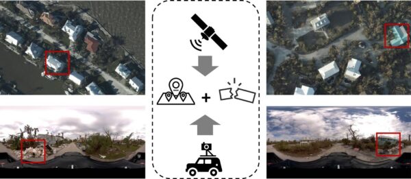
There are some scenes only street-view imagery can capture. These researchers are using Mosaic imagery from Hurricane Ian to train GeoAI models to identify post-disaster damage levels. When Hurricane Ian

Mosaic had the opportunity to speak with UCLA researchers about the devastating 2025 L.A. wildfires.


