
How to maximize FEMA reimbursement by better understanding the debris situation at hand with a 360º camera for street view imagery
In the wake of major natural disasters, the aftermath often looks like a trail of destruction and debris that can impede the recovery process. Debris removal emerges as a critical component in restoring normalcy and facilitating the path to recovery. This article delves into the importance of debris removal following emergencies. We will discuss the dangers and challenges posed by debris, the organizations involved in this crucial task, the significance of real-time data, and how efficient debris removal can aid entities in securing maximum reimbursement from FEMA.
What types of debris are created by natural disasters or emergencies?
After a natural emergency, several types of debris typically require removal:
Structural Debris:
This includes damaged or collapsed buildings, houses, and infrastructure such as bridges and roads. Structural debris often poses safety risks and obstructs access to affected areas.
Vegetative Debris:
Vegetative debris consists of fallen trees, branches, leaves, and other uprooted and damaged vegetation from the event. This type of debris can obstruct roads, power lines, and waterways. It can also contribute to the risk of secondary disasters like floods and fires.
Construction and Demolition Debris:
Construction materials, such as broken concrete, roofing materials, and other remnants from damaged or destroyed buildings, fall under this category. Clearing this debris is crucial for the rebuilding and reconstruction process.
Household and Personal Debris:
After a disaster, personal belongings, furniture, appliances, and other household items are often damaged or destroyed. Removal of such debris is necessary to create safe living conditions and allow residents to begin the recovery process.
Hazardous Materials and Contaminated Debris:
In some cases, natural disasters may result in the release of hazardous materials or contamination of the environment. This can include chemicals, oil spills, asbestos, or other toxic substances. This type of debris requires specialized handling and disposal procedures to ensure environmental safety.
What is debris removal?
Debris removal refers to the process of clearing and disposing of various types of materials, objects, and waste that accumulate in the aftermath of a natural emergency. It involves the systematic removal, transportation, and disposal of debris to restore affected areas and facilitate recovery.
How do you conduct debris removal?
Debris removal is typically conducted through a multi-step process:
Initial Assessment:
Authorities and relevant organizations assess the extent and types of debris present in affected areas. This helps determine the resources and equipment required for the removal process.
Learn about one Floridian survey company that captured street view data and visualized in less than 24 hours, significantly speeding up typical assessment time.
Prioritization and Planning:
Debris removal efforts are prioritized based on factors such as safety concerns, access to critical infrastructure, and the needs of the affected population. A comprehensive plan is developed to ensure efficient removal operations.
Clearing and Transportation:
Debris removal teams, often comprising government agencies, private contractors, and volunteers, physically clear the debris. Heavy machinery, such as bulldozers, cranes, and trucks, collects and transports debris to designated disposal sites.
Disposal and Recycling:
Debris is disposed of in appropriate landfills or recycling facilities, depending on the type of material. Efforts are made to maximize recycling and minimize the environmental impact of disposal.
Monitoring and Follow-up:
Monitoring activities are conducted to ensure that areas are cleared of debris and to identify any remaining hazards or residual debris requiring attention. Ongoing assessments inform the final stages of debris removal.
Effective debris removal is essential for restoring infrastructure, facilitating recovery, and ensuring the safety and well-being of affected communities.
What are the reasons for removing debris?
Unveiling the Dangers and Problems of Debris:
Debris in the aftermath of a natural disaster presents multifaceted challenges.
Firstly, it poses significant safety risks to residents, emergency responders, and recovery workers. Sharp objects, contaminated materials, and unstable structures can cause injuries and hinder relief efforts.
Secondly, debris obstructs transportation networks, blocking roads, bridges, and access to critical infrastructure. This hampers rescue operations and delays the delivery of essential supplies and services.
Organizations at the forefront of debris removal
Various organizations play a pivotal role in the removal of debris after emergencies. Local governments, public works departments, and disaster management agencies collaborate with specialized debris removal companies, contractors, and non-profit organizations. These entities possess the expertise, equipment, and manpower required to efficiently clear debris from affected areas. Their coordinated efforts contribute to expediting the recovery process.
Here are debris removal’s key players:
Local Municipality: The local municipality or government is responsible for coordinating and overseeing debris removal within its jurisdiction. They work closely with other agencies to assess the extent of the debris, establish priorities, and manage the removal process.
State Government: The state government plays a crucial role in coordinating and supporting debris removal efforts. They work with local municipalities to provide resources, equipment, and personnel necessary for debris removal. State agencies such as the state emergency management agency and the department of transportation are often involved in coordinating these efforts.
Federal Agencies: The Federal Emergency Management Agency (FEMA) is the primary federal agency involved in coordinating disaster response and recovery efforts. FEMA provides guidance, technical assistance, and financial support to states and local municipalities for debris removal. They may also deploy resources and personnel to assist in the process.
Private Contractors: Local municipalities often hire private contractors specializing in debris removal to assist with the cleanup process. These contractors have the necessary equipment, expertise, and manpower to efficiently remove debris. The contracts with these private companies are typically managed and overseen by the local municipality or state government.
Volunteer and Nonprofit Organizations: Volunteer groups and nonprofit organizations may also contribute to debris removal efforts. They often assist with the cleanup process by providing volunteer labor, equipment, and resources. These organizations work in coordination with the local municipality and other agencies involved in the recovery efforts.
It’s important to note that the specific roles and responsibilities of each entity may vary depending on the nature and scale of the disaster, as well as the specific jurisdiction and resources available. Collaboration and coordination among these entities are crucial to ensure effective and timely debris removal after natural disasters.
Real-time data: The key to efficiency and accuracy
To ensure effective debris removal, real-time data becomes an invaluable asset. Technological advancements, such as Geographic Information Systems (GIS) and remote sensing, aid in the rapid assessment and mapping of debris. This data helps prioritize areas with the highest concentration of debris, enabling removal teams to strategize their operations and allocate resources efficiently. Accurate data also assists in estimating the volume and types of debris, facilitating proper disposal methods and recycling efforts.
Capturing real-time, high-quality data can be difficult. Recently, many companies and governmental agencies have found that an easy solution is collecting street-view imagery at scale with a 360º mobile mapping camera in order to create their own private street-view of the affected area.
Check out the full story here about how one Mosaic customer was able to capture and process data in less than 24 hours.
Maximizing Reimbursement from FEMA
Proper documentation and adherence to FEMA guidelines are crucial for entities seeking reimbursement for debris removal expenses. Real-time data plays a vital role in this process as well. Timely and accurate reporting of debris removal activities, costs incurred, and supporting evidence is essential for entities to receive the maximum reimbursement.
By providing comprehensive data, organizations involved in debris removal contribute by
- streamlining the reimbursement process
- minimizing delays
- ensuring fair compensation for their efforts
The process for local municipalities to request and file for FEMA reimbursements for debris removal from natural emergencies may vary slightly depending on the specific circumstances and requirements of each incident. However, we can provide you with a general outline of the typical steps involved.
Steps for filing with FEMA:
Declaration of Emergency
The first step is the declaration of a state of emergency by the local government or state authorities. This declaration should be made as soon as possible after the natural disaster occurs.
Contact FEMA
Once the emergency is declared, the local municipality should establish contact with the Federal Emergency Management Agency (FEMA) to initiate the reimbursement process. The municipality can reach out to the appropriate FEMA regional office or state emergency management agency for guidance.
Preliminary Damage Assessment (PDA)
FEMA will typically conduct a Preliminary Damage Assessment to evaluate the extent of the damage and determine the eligibility for federal assistance. This assessment may involve FEMA representatives and local officials surveying the affected area to estimate the amount of debris and the associated costs of removal.
Documentation and Record Keeping
It is crucial for the local municipality to maintain detailed documentation of all debris removal activities. This includes records of expenses, contracts with debris removal contractors, personnel costs, equipment usage, and any other relevant documentation. Accurate and comprehensive record-keeping is essential for the reimbursement process.
Project Worksheet Development
The local municipality will work with FEMA to develop Project Worksheets (PWs) for debris removal. These worksheets outline the scope of work, estimated costs, and the eligible expenses for reimbursement. The municipality should include all necessary information and supporting documentation in the PWs.

Cost Estimation and Reimbursement
FEMA will review the PWs submitted by the local municipality. They will evaluate the eligibility of the expenses and determine the appropriate reimbursement amount. It’s important to note that FEMA typically reimburses a percentage of the eligible costs. The exact percentage may vary depending on the type of disaster and the specific disaster declaration.
Reimbursement Request
Once the PWs are approved by FEMA, the local municipality can submit a formal request for reimbursement. This request should include the approved PWs and any additional required documentation. FEMA will process the request and provide the reimbursement to the municipality.
It’s worth mentioning that the above steps provide a general overview of the process. There may be additional requirements or variations depending on the specific circumstances and FEMA regulations. Therefore, it is crucial to maintain regular communication with FEMA and follow their guidance throughout the reimbursement process.
Some of the largest natural disasters in recent U.S. history, and the debris removal costs
If you didn’t think debris removal could be so expensive, think again:
Hurricane Harvey (2017):
Hurricane Harvey made landfall in Texas in August 2017, causing catastrophic flooding and extensive damage. It is considered one of the costliest hurricanes in U.S. history, with an estimated $125 billion in damages. The storm affected numerous cities, including Houston, and resulted in the displacement of thousands of residents.
Houston received $91 million, and the remainder of Harris County received $44 million to pay for debris removal. The storm left 200 million cubic yards of debris. (source)
Hurricane Irma (2017):
Hurricane Irma, a powerful Category 5 storm, affected several U.S. states and territories in September 2017. The hurricane caused widespread destruction and resulted in at least 84 fatalities. The Florida Keys, the Caribbean islands, and parts of Georgia were among the most severely impacted areas.
FEMA awarded grants totaling $42,559,595 for the State of Florida to reimburse applicants for debris removal, administrative costs, and repairs following Hurricane Irma in 2017.
The FEMA Public Assistance program grants included:
Florida Department of Transportation: $23,546,676 for debris removal in Miami-Dade and Monroe counties. Crews removed 160,088 cubic yards of vegetative debris, 173,921 cubic yards of construction and demolition debris, 84,333 large household appliances, 232 hazardous leaning trees, and 2,135 hanging limbs.
Miami-Dade County: $9,464,457 for administrative costs of tracking and accounting for labor, equipment, materials, and other costs.
Orange County: $5,495,325 for removal of more than 470,803 cubic yards of vegetative debris from roads and public property, including rights-of-way.
Withlacoochee River Electric Cooperative, Inc.: $4,053,137 for service to nine counties, including the cost of labor, equipment, materials, contracts, 293 utility and transformer poles, 329 transformers, 26,852 feet of damaged conductor, and 35 security lights. (source)
Hurricane Sandy (2012):
Hurricane Sandy struck the northeastern United States in October 2012, causing extensive damage and loss of life. It affected multiple states, including New York, New Jersey, and Connecticut. The storm surge led to severe flooding in coastal areas, particularly in New York City, resulting in billions of dollars in damage and the loss of over 230 lives.
Three-quarters of the $178 million in federal emergency grants awarded to Long Island towns, villages, schools, and nonprofits in the first five months since superstorm Sandy struck were used for debris removal, government records show. (source)
Hurricane Ian (2022): A Record-Breaking Category 5 Storm Ravages Florida
Hurricane Ian, a formidable Category 5 hurricane, left a trail of destruction and devastation in its wake, cementing its place as the third-costliest weather disaster in history. Unleashing its fury upon Florida, it became the deadliest hurricane to strike the state since the infamous Labor Day hurricane of 1935. Additionally, Ian wreaked havoc in western Cuba and caused considerable damage in the Carolinas. This powerful storm marked the ninth named storm, fourth hurricane, and second major hurricane of the 2022 Atlantic hurricane season.
More than $1.67 billion in federal grants, disaster loans, and flood insurance payments have been provided to the State of Florida and to households after Hurricane Ian. FEMA has provided $680 million to households and $322 million to the state for emergency response, while the U.S. Small Business Administration has provided $429 million in disaster loans, and the National Flood Insurance Program has paid $244 million in claims. (source)
These natural disasters have had a profound impact on the affected regions, resulting in significant loss of life, property damage, and long-term recovery efforts.
Tools and monitoring methods for debris removal
Monitoring debris and debris removal following a natural disaster involves employing various methods and technologies to assess the extent of debris and track the progress of removal operations. Here are some common methods:
Aerial Surveys and Remote Sensing:
Aerial surveys using drones, helicopters, or satellites provide valuable imagery and data to assess the scope and distribution of debris. High-resolution aerial imagery helps identify heavily impacted areas, estimate the volume of debris, and track changes over time. Remote sensing techniques, such as LiDAR (Light Detection and Ranging) and radar, create detailed topographic maps and identify areas with high debris concentration.
One of the most important elements in disaster recovery is visual.
“You want to see progress”
Jeff Byard
executive officer of the state EMA and Alabama’s coordinating officer for the recovery following “2011 Super Outbreak” (a series of over 175 tornadoes, striking Alabama, Mississippi, and Tennessee, from April 25 to 28, 2011.
Army engineers rely on the National Geospatial Intelligence Agency to provide satellite images of grids on a map of disaster areas. These images help pinpoint those grids with heavy enough debris to be approved for reimbursed removal. But satellite images are not always as reliable as reported:
“In this part of Alabama we get afternoon thunderstorms, and those satellites don’t see through the clouds”
Phyllis Little, Cullman County EMA Director
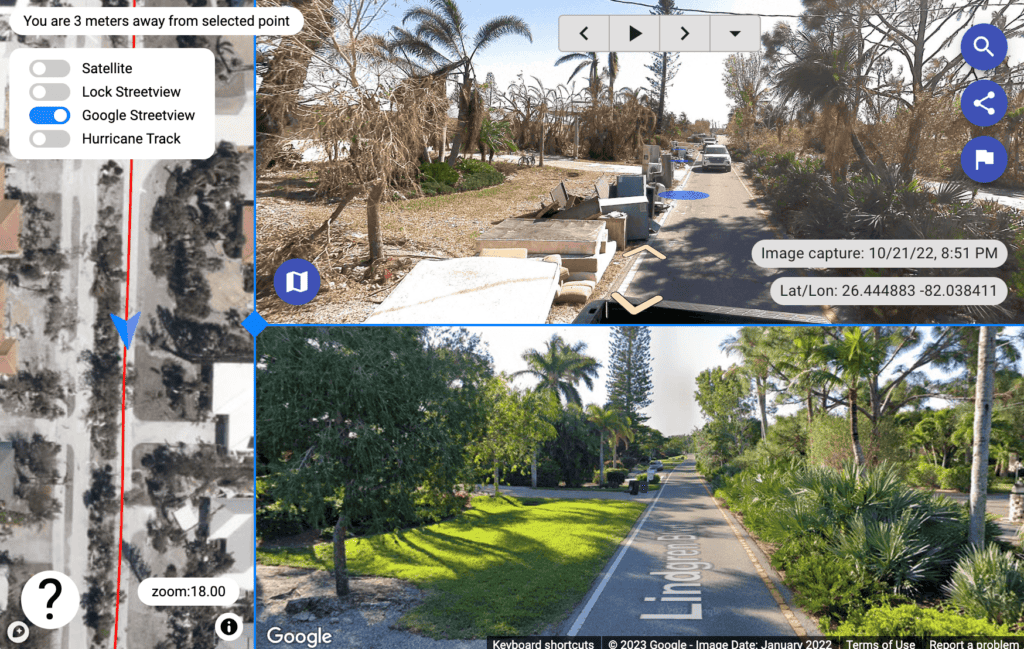
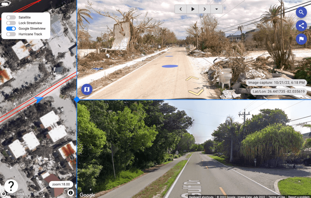
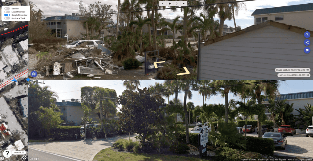
Street view mobile mapping solutions:
Collecting street view images of the debris caused by major natural disasters enables those removing the debris to understand the situation at hand and to respond quickly. Furthermore, this information can be utilized by the towns or cities affected as evidence to provide FEMA when requesting reimbursement for the costs incurred for the removal. With a full 360º image of the streets, there is a higher likelihood that sufficient images will be collected and available for use later in the process.
What is even more beneficial is to compare the conditions of the roads and properties affected with data from before the natural disaster. The conditions of the roads before the storm can prove the damage done, not only by the storm itself, but also by the heavy vehicles that were brought into the area to assist with the aftermath.
This comparison is possible only if there is relatively up-to-date Google Street View imagery or if the location has recently collected this sort of imagery at scale for such purposes.
Geographic Information Systems (GIS):
GIS technology allows for the spatial analysis and mapping of debris. It helps visualize and manage data related to debris removal, including debris locations, types, and quantities. GIS tools enable better decision-making by providing a comprehensive view of the debris situation and facilitating efficient resource allocation and planning.
Data Analysis and Management Systems:
Effective monitoring requires robust data analysis and management systems. These systems enable the integration, organization, and analysis of various data sources, such as aerial imagery, field surveys, and community reports. Data analytics help identify trends, patterns, and areas requiring immediate attention, contributing to efficient decision-making and resource allocation.
Collaboration with Stakeholders:
Collaboration with various stakeholders, including local authorities, emergency management agencies, debris removal contractors, and nonprofit organizations, is crucial for effective monitoring. Regular coordination meetings, data sharing, and collaborative platforms facilitate real-time updates, enhance communication, and ensure a coordinated approach to debris removal efforts.
By employing these monitoring methods, emergency management agencies and stakeholders can gather accurate information, track progress, and make informed decisions throughout the debris removal process. This facilitates efficient resource allocation, helps prioritize areas of high impact, and ultimately aids in expediting the recovery and rebuilding efforts in the aftermath of a natural disaster.
Conclusion
The importance of debris removal following major natural disasters is significant. By recognizing the dangers and problems posed by debris, understanding the role of different organizations, leveraging real-time data, and prioritizing efficient removal, entities involved in debris removal not only expedite the recovery process but also increase their chances of obtaining maximum reimbursement from FEMA. Clearing the path to recovery requires a concerted effort, with debris removal serving as an essential pillar in rebuilding resilient communities.
If you’re looking to increase your FEMA reimbursements by collecting more reliable images during the debris removal process, we’d love to help.
Contact us below and we’ll be in touch!


