
Mosaic case study: How one professional UK surveying company was able to scale quickly while reducing costs by 20%
Major findings
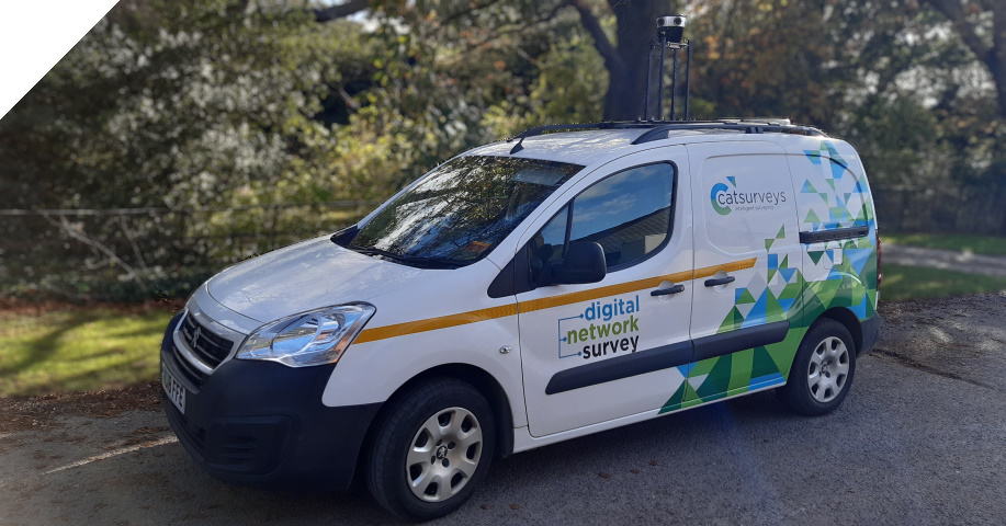
DNS (Digital Network Survey) by Catsurveys Ltd can quickly collect asset data across extensive geographical areas. With their Mosaic 51 camera system, they capture highly accurate digital data sets, providing essential site insights throughout project lifecycles. With this enriched data and the expertise of surveyors, the team achieves remarkable project enhancements:
- ✔ Connecting up to 16% more homes
- ✔ Reducing connections by up to 25% using PIA underground
- ✔ Shortening new self-dig lengths by up to 71%
- ✔ Decreasing self-dig costs by up to 66%
- ✔ Increasing connected properties by up to 500% using PIA overhead
Catsurveys: underground utility detection specialists
Catsurveys is a leading UK professional surveying company. They specialize in utility surveying, underground utility detection (UUD), mobile mapping, building information modeling (BIM), ground penetrating radar (GPR), topographical surveys, telecommunications, and more.
Catsurveys has made the best of the impact that the COVID pandemic has had on its markets and clients. They have adapted, becoming a lean business and scaling down their office space, embracing hybrid working throughout the pandemic and establishing it as normal practice. They’ve even managed to grow and innovate in these unprecedented times, embodying one of their core values:
Drive continual improvement and innovation.
Catsurveys Values
In that spirit, they took the opportunity to improve one of their services during the pandemic: mobile mapping.
Physical Infrastructure Access (PIA) challenges for mobile mapping
In late 2020, one of Catsurveys’ Tier 1 telecommunications customers presented Catsurveys with a challenge. The client was just starting to get into the PIA market. They were looking for a solution that would speed up the surveying process and improve the quality of the data.
Physical Infrastructure Access (PIA) addresses the critical need for expanding high-capacity broadband globally. It enables service providers to install fiber networks using existing ducts and poles of incumbent operators, reducing the reliance on extensive civil engineering efforts. PIA gained prominence after the European Commission recommended regulated access to next-generation networks, prompting National Regulatory Authorities (NRAs) across Europe to implement supportive measures.
In the UK, PIA is an Openreach product granting Communication Providers (CPs) access to its infrastructure, subject to approval. This initiative promotes the efficient use of existing physical assets, benefiting all stakeholders, particularly Communication Service Providers (CSPs), by facilitating faster and more cost-effective network deployment.

Catsurveys previously had undertaken mobile mapping and were able to set up the service using a new piece of equipment to re-enter, so to speak, into the mobile mapping market.
The equipment used proved to be an incredibly strong and reliable piece of machinery and a powerful tool in mobile mapping service, although it raised some issues in the use for Telecoms Surveys:
Biggest issues
1. Weight – The equipment was a two-person lift onto the roof of the vehicle. and presented some risks to one of Catsurvey’s other values, safety:
We never compromise on safety.
Catsurveys Values
Working with a 50+ kilo system meant that Catsurveys’ employees needed extra equipment to ensure safety when lifting the device.
2. Cost – The equipment used clocks in at about 1/2 million GBP, which is by no means a small amount. With this sort of financing, there was no way this solution would have been scalable if Catsurveys was looking to build a fleet of mobile mapping vehicles.
3. Required resources – Due in large part to the weight of the equipment, as well as the need to have personnel within the vehicle at all times monitoring the workstation, this was without a doubt, a two-person job.
4. Imagery – the images gathered by the equipment were not adequate with only 2×12 MP image sensors for only a total 24MP equirectangular image. While the point cloud and measurements were great,
It’s not what the telecoms industry wanted. What they really wanted was the imagery, and the imagery we were collecting was not reaching their needs.
Dan Davis, Head of Delivery at Catsurveys

The hunt for a mobile mapping solution
So Dan and his team set about looking for a mobile mapping solution that was cost-effective, scalable, and easier to manage in the field. Their research led them to several vendors of 360° cameras, including Mosaic and the Mosaic 51.
They immediately liked the look of the product, and comparing the M51 specs to other market solutions, they felt it was the only solution that would meet their needs. In the field of vehicle-mounted units, they did not see anything comparable and decided to buy two units.
It compared very competitively on technical specification alone, with everyone else out there on the market, and I think it still does.

Telecomms infrastructure surveying with Mosaic51
Catsurveys was immediately convinced that they had made the right decision. The M51 checked off all of the boxes (previously mentioned above) that made their previous mobile mapping solution inefficient for the job.
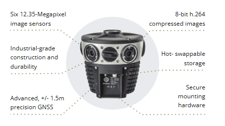
1. Weight – the Mosaic 51 weighs only 4.6 kilos, meaning that a single person can safely and easily mount the camera without the need for extra equipment and quicker.
2. Cost – The Mosaic 51 is considerably cheaper than the existing equipment (contact the Mosaic Sales Team for current pricing). This allowed Catsurveys to purchase two to start, with the plan to buy two more in 2022.
which is why we’ve ended up with a couple of new cameras and still have the intent of buying more as our client base grows.
Dan Davis
3. Required resources – The Mosaic 51 comes with built-in processors, including a CPU and GPU, meaning all computing is done onboard without the need for an additional workstation or computer within the vehicle. Thanks to this and the lightweight, the Mosaic 51 is rugged, robust, and operable by one person: installation, driving, and collecting.
4. Imagery – The Mosaic 51 contains 6x12MP image sensors for a total 75.5MP / 12.3K equirectangular image
….definition and depth of imagery is far better.
Dan Davis
What were the results?
Dan summed up the results as such:
Our approach with your camera, absolute winner. There isn’t any part of the process where we’ve felt that we’re going backwards.
We’ve scaled a long way without increasing our site resources because 70% of work is done by the office resources we have (compared to traditional surveying methods)
We were able to move the price point of individuals down somewhere in the region of 40%, being able to work like this……quite an attractive proposition…..
That’s enabled us to stay competitive. With our client, it hasn’t cost us more, and they’re not paying any more. They have a much better outcome, and more importantly the pace. We can cover somewhere in the region of 3,500 homes in a day. Contrasted with one surveyor, capturing images, can cover about 200 homes per day.
On top of that, Dan commented about the technical support offered by the Mosaic team, saying that the turnaround time was ‘impressive’.
For this sort of equipment, this makes you stand out from the crowd
High quality service
Watch Dan Davis sharing his experience with the Mosaic 51 camera:
Conclusion
Are you in the UK and looking for a professional surveying company? Head over to Catsurveys to learn more about their solutions and say Mosaic sent you.
Looking for similar results to what Catsurveys got? Contact the team here at Mosaic and we’ll be more than happy to help find your solution.


