Meridian imagery and LiDAR data are now compatible with Ranger and Pathfinder software from New Compass Solutions
Mosaic is announcing a partnership with New Compass Solutions. Their Pathfinder visualization platform and Ranger extraction platform now support data from the Mosaic Meridian Mobile Mapping System.
The partnership delivers immediate value to infrastructure professionals across surveying, mapping, utilities, transportation, and municipal sectors. Organizations investing in Meridian systems (both Meridian and Meridian Lite) can now seamlessly integrate that data into Ranger’s cloud-native extraction environment and Pathfinder’s web-based visualization platform.
The result is an end-to-end workflow that eliminates traditional cost barriers, complexity, and vendor lock-in while delivering the precision and reliability that demanding infrastructure projects require.
Mosaic Meridian: professional, accessible mobile mapping
Mosaic launched the Meridian Mobile Mapping System in response to a field traditionally dominated by expensive, complex systems. It combines the Mosaic X 360-degree camera with the Phoenix Scout-M2X LiDAR to deliver a fully integrated, calibrated mobile mapping solution.
Meridian’s main advantage is its balanced approach to data collection. Unlike bulkier mobile mapping systems, it captures appropriately dense point clouds alongside ultra-high-resolution imagery. This reduces the processing and data transfer time without compromising on quality.
The Meridian features:
- 74MP native resolution
- Global shutter sensors for clear imagery at highway speeds
- An integrated INS system with a vertical accuracy of 2-3 cm and a horizontal precision of 2-4 cm
- Operability from 0–45°C and in high humidity conditions
- Easy set-up thanks to out-of-the-box calibrated components
New Compass Solutions’ Ranger and Pathfinder
The Ranger and Pathfinder platforms solve the critical inefficiencies that have long plagued geospatial data extraction and visualization workflows.
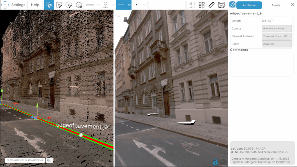
Ranger: Precision LiDAR extraction at scale
Ranger is New Compass Solutions’ cloud-native platform for full-spectrum 3D geospatial data extraction. Unlike legacy platforms that require massive dataset downloads to individual workstations, Ranger streams point cloud data directly from secure AWS cloud storage. Extractors access a gamified environment for efficient navigation through complex 3D data, working in real-time without local file management. This architecture eliminates costly data transfers, reduces hardware expenditures, and enables seamless collaboration across distributed teams.
Security is built into the architecture so that source data never resides on local machines, remaining in secure AWS storage with controlled access. One of Ranger’s most powerful features is its flexible data dictionary system, allowing organizations to tailor asset and attribute definitions for any project type with parent-child relationships that export in final deliverable formats.
Ranger’s capabilities include the following modules:
- Basic Module: Complete project management, data upload and organization, custom data dictionary creation, user assignment, extraction tools, and GIS export functions—everything needed for large-scale extraction projects.
- Audit Module: Statistical defect sampling algorithms automatically identify validation requirements, providing Audit Scores with 95% confidence for defendable quality metrics.
- Classification Module: Machine learning automatically classifies point clouds into nine categories (ground, vegetation, buildings, noise, wires, poles, signs, barriers, supports), accelerating workflows and improving consistency.
- Vegetation Encroachment Module: Automatically detects trees, extracts wires and poles, analyzes configurable danger zones, and determines tree fall risk with comprehensive visual reporting for vegetation management programs.
Ranger blends automation with human expertise, using automated processes for repetitive measurements while human extractors apply domain knowledge to ensure accuracy.
Pathfinder: making geospatial intelligence accessible
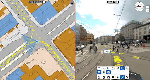
Pathfinder is New Compass Solutions’ web-based visualization platform that simplifies access to complex geospatial information. The interface simultaneously presents panoramic imagery, LiDAR point clouds, and georeferenced extracted assets in a unified view so that the users can see street-level panoramic photos, corresponding 3D point clouds, and asset data with customizable icons all in the same interface.
Pathfinder provides measurement tools (point, line, polygon, vertical) to allow users to make quick analyses directly within point cloud data. Organizations can upload any geographically referenced data for layered insights (think GIS databases, maintenance records, planning documents, etc.). This creates a comprehensive spatial intelligence platform accessible through any modern browser without specialized software or technical expertise.
Additionally, Pathfinder’s collaboration features allow users to save their favorite locations, share links with stakeholders, and download data directly. This transforms Pathfinder from a passive viewer into an active working environment for distributed teams.
Gain freedom of choice to use the software you want
This latest partnership with New Compass Solutions represents Mosaic’s commitment to full freedom of choice when it comes to your data. Our mobile mapping systems are non-vendor-locked, allowing you to choose from any number of software platforms.
Similarly, Ranger and Pathfinder accept data from any mobile mapping system without requiring separate workflows, different tools, or format conversions. Sensor-agnostic platforms and hardware are wise for future-proofing your workflow investments.
Conclusion: Partnership for Progress
The integration of Mosaic Meridian support into Ranger and Pathfinder demonstrates shared values coming together to serve infrastructure professionals better. Mosaic’s Meridian makes high-quality mobile mapping accessible through exceptional image quality, survey-grade accuracy, and user-friendly operation. Ranger and Pathfinder make powerful extraction and visualization accessible through cloud-native architecture and sensor-agnostic design.
“We are excited to be able to host Mosaic data in our platforms. The Meridian mobile mapping system data speaks for itself, with excellent point cloud and imagery quality that makes extraction easier than ever, and their team has deep industry knowledge and clear enthusiasm for mapping technology. We look forward to innovating together!”
-Margaret Dudzinski, CMO at New Compass Solutions
Together, these technologies create an end-to-end workflow that’s more accessible, efficient, and flexible than traditional alternatives. Organizations can invest in Meridian knowing their data flows seamlessly into professional-grade platforms.
Whether you’re using Mosaic Meridian systems, considering them for future projects, or working with any other mobile mapping technology, New Compass Solutions provides the extraction and visualization infrastructure to make your geospatial data work harder.
About New Compass Solutions
New Compass Solutions is a Northern Virginia-based geospatial intelligence company specializing in LiDAR data platforms, Ranger and Pathfinder. Ranger is a cloud-native, sensor agnostic, and highly customizable extraction platform. Pathfinder is a web-based visualization platform for LiDAR, panoramic images, and extracted assets. New Compass Solutions serves municipal, utility, transportation, and telecommunications clients with comprehensive infrastructure intelligence services.
About Mosaic
Mosaic is a leader in 360-degree camera technology, providing high-resolution, high-speed imagery solutions for a variety of industries, including mapping, surveying, and infrastructure management. Mosaic’s cameras are known for their ease of use, high image quality, and ability to seamlessly integrate into diverse workflows, offering flexibility and precision for any project.
Press Contact:
Lynn Puzzo, Director of Sales and Marketing