
Is a point-cloud arms race really necessary? How dense is too dense for AI models?
For more than a decade, the mobile laser scanning (MLS) industry has gotten caught up in an arms race. One million points per second. Two million. Five million.
On spec sheets, these millions of points look impressive, but in the field and in the office, they are often overkill.
At Mosaic, we spend a lot of time with teams who are at all stages of the point cloud pipeline. But no matter the industry or job, the same limiting factors keep appearing.
While the question used to be “Can we capture enough points?”, now we hear, “Can we move, process, and actually use all these points?”
“For product design and engineering, it’s good to remember that “perfect is the enemy of good”. We are building tools that people pay for, both with money and time. While it’s always true that anything can be better (a point cloud can be denser, a photo can be higher resolution, and so on), we need to keep the economic reality in mind of “why are we doing this, and to what end?”.
Paying close attention to this will allow the stakeholders to have a solution that does only what they need, and not more. This should of course end up being cheaper than the nuclear option of “let’s use the most expensive equipment possible to create the densest possible data”.”
-Jeffrey Martin, CEO of Mosaic
If conversations in your team have turned to, “How dense is too dense?”, you’re in the right place.
The hidden costs of the point-count arms race
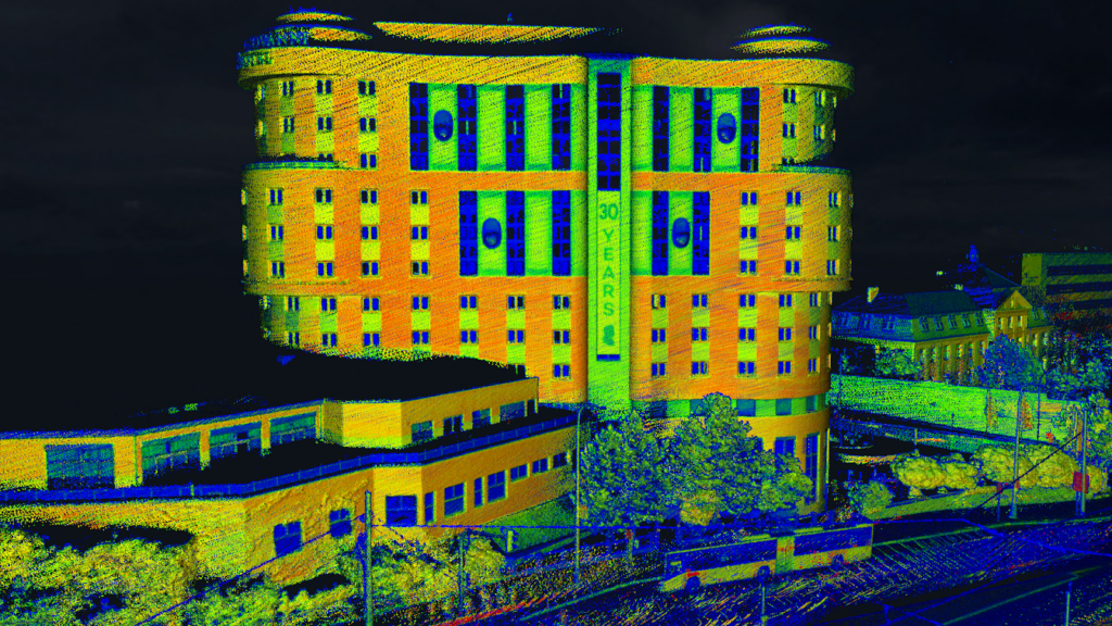
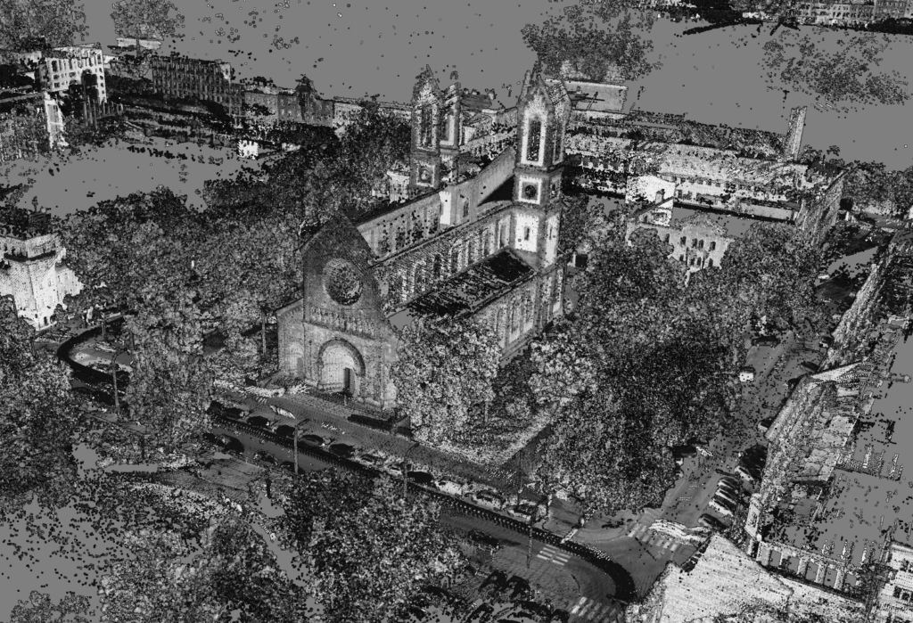
Modern MLS systems can now easily produce multi-terabyte projects in a single week. Ultra-dense point clouds sound like a quality guarantee, however, there are expensive consequences to having such a large dataset.
- Field productivity drops: To hit extreme densities, some systems push operators toward slower driving speeds or multiple passes. This adds to crew time, fuel costs, and can impede on safety, especially on highways.
- Data transfer becomes a bottleneck: Moving multi-terabyte datasets from the vehicle to the office, then into multiple software platforms, can eat into precious project hours.
- Processing queues explode: Registration, cleaning, colorization, feature extraction, and re-tiling all scale with data volume. If every run is “maximum density,” the backlog never truly clears.
- Decimation becomes mandatory: Ironically, most teams end up thinning their point clouds before running AI or CAD workflows, just to make them manageable again. In other words, when using ultra-dense MLS systems, geospatial teams work hard to create data that is often immediately removed.
What do AI models actually need?
For AI models, such as those used in object detection and semantic segmentation, more data points are not always synonymous with better results. What models really need is:
- Sufficient density around important geometry: Curbs, poles, guardrails, building edges, overhead wires. Once you pass the threshold where these features are clearly and consistently represented, additional points tend to yield diminishing returns.
- High signal-to-noise ratios: Clean, stable trajectories and well-calibrated sensors are more valuable than marginal increases in density. Noisy, overlapping point clouds can confuse AI models more than help them.
- Consistent sampling patterns: AI pipelines benefit when data looks similar from project to project. Wild swings in density or scan patterns make training and generalization harder.
- Perfect alignment between imagery and LiDAR: Panoramic images carry rich semantic information that many people (and AI models) understand more intuitively than raw point clouds. If these images are tightly aligned with LiDAR, you can combine the strengths of both.
- Reasonable file sizes: If data is so heavy that it cannot be streamed to cloud tools or shipped to partners, AI never gets a chance to work on it.
In short, AI needs the right points, captured in a disciplined way, and connected to high-quality imagery.
Meridian and Meridian Lite
When we designed the Meridian and Meridian Lite MLS systems, our starting point was not “How many points per second can we claim?” It was “What do experts in the field actually need, and how can we help them capture exactly that?”
From that launching point, a few design principles emerged, namely, aligning LiDAR density with high-resolution panoramic imagery.
Balanced LiDAR density
Meridian and Meridian Lite both use a Phoenix Scout-M2X LiDAR unit capable of up to 800,000 points per second. This is dense enough for road inventories, city-scale mapping, BIM corridors, and most asset management tasks, without pushing data volumes into an unmanageable range. In practice, an 800,000-point density supports:
- Automatic feature extraction in tools such as TopoDOT, Ranger, or other 3D point cloud analysis platforms.
- Reliable curb, lane, and façade reconstruction for GIS and 3D modeling.
- Consistent object representation for AI training, from poles and signs to trees and barriers.
Instead of capturing every conceivable photon, we target a density that is “just right” for most extraction and modeling projects.
“At Phoenix LiDAR, we build some of the most advanced mapping systems in the industry but sometimes we don’t give them the spotlight they deserve. One system I believe deserves more attention is the Scout-M2X paired with the Mosaic 51 360° Camera Mast. This combination is ideal for organizations looking to capture both 360° imagery and LiDAR spatial data but on a limited budget.”
-Grayson Omans, CEO of Phoenix LiDAR
Industry-leading panoramic imagery
On the imagery side, Meridian uses the Mosaic X camera, which delivers 91.2 MP equirectangular resolution and 13.5K panoramas through synchronized global-shutter sensors.
When working with LiDAR, high-resolution images let AI see textures, colors, and subtle visual cues that point clouds cannot express.
Inspectors, engineers, and city stakeholders who are not LiDAR experts can also benefit from an imagery-first approach. They can still review and understand the capture through street-level imagery.
On the technical side, photogrammetry and image-based change detection become viable parallel workflows, using data from the same drive.
Crucially, these images are tightly aligned to the LiDAR data, which is one of the core requirements of an AI-ready data stack.
Meridian Lite, on the other hand, uses the Mosaic 51 camera with 12.5K rolling shutter lenses. This lower-priced option is great for city-scale mobile mapping projects that require fast turnarounds. Grayson Omans, CEO of Phoenix LiDAR, had this to say:
“Contrary to popular belief, many customers don’t require RGB projection into their LiDAR point clouds. In these cases, the added expense of a global shutter 360° camera isn’t necessary.”
Rethinking what performance means in mobile mapping
In traditional marketing, performance is often equated with extremes: maximum points per second, maximum range, maximum configuration options, etc. But at Mosaic, we argue for a more holistic definition of performance. We ask:
- How quickly can a small team go from planning and set-up to having concrete deliverables?
- How easy is it to integrate the captured data into existing GIS, CAD, and AI ecosystems?
- How many times can you reuse the same capture for new applications, without recapturing?
By pairing high-resolution (12.3 or 13.5K) panoramic imagery with a right-sized LiDAR stream, our Meridian MLS system lineup aims to give you exactly the data you need for AI models and downstream products, without locking you into a specific image-processing vendor or crushing your storage and computation budgets.
“We are excited to be able to host Mosaic data in our platforms. The Meridian mobile mapping system data speaks for itself, with excellent point cloud and imagery quality that makes extraction easier than ever, and their team has deep industry knowledge and clear enthusiasm for mapping technology. We look forward to innovating together!”
-Margaret Dudzinski, CMO at New Compass Solutions
Focusing on your client’s deliverables
Raw point clouds are rarely what your end clients buy. They buy final deliverables, such as updated GIS databases, BIM models, digital twins, 3D meshes, asset inventories and maintenance plans
Collecting unnecessary points only slows the journey from reality to these deliverables. By capturing a balanced dataset, Meridian and Meridian Lite help AI tools focus on what matters, such as feature classification and extraction. The result is a cleaner pipeline from the data capture to mapped assets, without the data bloat that many legacy MLS users have learned to accept.
“Dense, high “resolution” point clouds can be beautiful to watch, but also a lot of time to open them or navigate in them. Most of the time we collect LiDAR data because we would like to map something on a large scale – roads, infrastructure, cities, etc. At the end of the day we need to extract information from the point cloud and a too dense dataset can be frustrating to work with.
With the Mosaic Meridian you will get high resolution images which can be understood by anybody, and the point density of the LiDAR dataset will be ready for any AI and automatic feature extraction workflow.”
-Ivan Hepp, Product Manager at Mosaic
Our CEO breaks down the case for appropriately-dense LiDAR over on our YouTube channel:
So, how dense is too dense?
There is no universal magic number. Road inventories, forest plots, rail corridors, and dense historic districts all have different requirements. But if any of these statements are true, it’s time to reconsider your MLS system:
- Your team consistently decimates point clouds before they reach AI or CAD.
- Your uploads run overnight and still are not finished in the morning.
- Your stakeholders ask for “just the images,” because the point clouds are overwhelming.
With Meridian and Meridian Lite, our goal is to help you step off the point-cloud treadmill. Talk to our team today about which MLS system is right for your projects.


