
Documenting Lahaina and LA’s Wildfire Damage with Street-Level Imagery
When UCLA and the University of Hawaii’s research programs need high-resolution 360° imagery of wildfire aftermath, they turn to Mosaic cameras.

Mosaic enhances insurance risk assessment with precise, pre-event insights and reduced claim ambiguity
When UCLA and the University of Hawaii’s research programs need high-resolution 360° imagery of wildfire aftermath, they turn to Mosaic cameras.
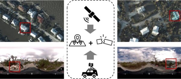
There are some scenes only street-view imagery can capture. These researchers are using Mosaic imagery from Hurricane Ian to train GeoAI models to identify post-disaster damage levels. When Hurricane Ian
During emergencies, every hour counts. Learn how McKenzie Intelligence Services uses Mosaic’s mobile mapping camera system to speed up the insurance claim process and bring policyholders peace of mind. Financial


