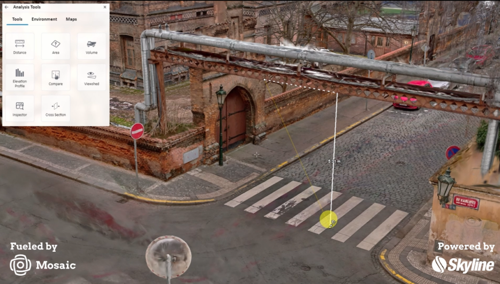
“Large-scale and simple” – High-resolution 360° imagery can now be automatically transformed into city-scale Gaussian Splats, photorealistic 3D models, and dense point clouds
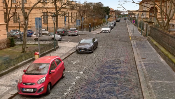
Prague, Czech Republic
Mosaic announces its large-scale 3D reconstruction pipeline purpose-built for street-level mobile mapping data. The workflow takes raw imagery captured by Mosaic camera systems and produces dense point clouds, textured meshes, and 3D Gaussian Splats.
These outputs are available automatically, at city scale, with no specialized hardware or software required on the customer side.
For teams already capturing the world with Mosaic cameras, this means the data they are already collecting can now yield a new class of 3D deliverables, without additional fieldwork or complex post-processing toolchains. This applies to those mapping utility infrastructure, road corridors, urban assets, highway networks, and everything in between.
Accessible city-scale 3D reconstructions
Street-level 3D reconstruction at city scale has been, until now, practically out of reach for most teams. Processing the volume of imagery required to reconstruct even a mid-size city demands compute resources far beyond what a standard desktop workstation can provide. Teams have historically faced a choice between expensive specialist infrastructure, slow external processing pipelines, or simply not delivering 3D at all.
Mosaic’s pipeline collapses that barrier. By combining the precise calibration and accurate positional metadata built into Mosaic camera systems with a cloud-based processing engine, the workflow eliminates the need for customers to manage GPU hardware, install complex software, or stitch together multi-vendor toolchains.
The final output is professional-quality 3D, delivered at a scale and speed that was not previously accessible to field teams.
The pipeline outputs
- 3D Gaussian Splats: The emerging standard for navigable, photorealistic large-scale 3D environments. Now achievable at city scale.
- Dense Point Clouds: Generated from imagery alone – no LiDAR required. Useful for measurements, asset extraction, and spatial analysis.
- Textured Meshes: Photorealistic 3D surfaces ready for inspection, documentation, and delivery to any stakeholder.
All three output types can be generated from Mosaic-captured imagery alone. LiDAR integration is supported but not required, as point clouds can be derived purely from the camera data. This flexibility makes the workflow accessible without requiring additional sensor investment.
Quality in, quality out
The quality of any 3D reconstruction is determined by the quality of the input data. Mosaic cameras are engineered with this principle in mind: every system delivers high-resolution imagery with accurate GPS positioning and known camera geometry. By focusing on quality inputs, 3D reconstruction can proceed at the city scale without the manual alignment and aerotriangulation work that typically requires specialist engineers.
Mosaic’s data preparation pipeline standardizes calibration, pose metadata, and image geometry before handoff to the cloud processing engine. This means the engine can focus on pose refinement – a fast, efficient step – rather than rebuilding geometry from scratch using Structure from Motion (SfM).
The results? Faster turnaround, lower processing cost, and consistent output quality across projects.
This city-scale cloud reconstruction engine, powered by Skyline, enables datasets of any size to be handled without local computation constraints. Build Gaussian Splats, point clouds, and textured meshes of a single city block, thousands of miles of road corridor, and every size in between.
“Gaussian Splats are the most exciting thing to hit 3D in a decade and everyone knows it. You can feel it. But the field has been stuck in first gear, because wanting the future isn’t the same as shipping it.
Everyone’s been circling the same question: how do you actually work with these things? We went straight at it. Big and simple. No trade-offs, no asterisks. And we cracked it. Large-scale splats are a solved problem now. Not a demo, not a teaser, but a pipeline.
You can build at the scale our customers actually live at, the scale the real world demands. This is the inflection point. Everything downstream of this gets faster, bigger, and more real. The splat era doesn’t start someday. It starts here.”
– Jeffrey Martin, CEO and Co-Founder at Mosaic
A single 3D reconstruction tool for a range of industries
This 3D reconstructor is the right-sized tool for a variety of use cases and industries. This pipeline is designed for the customers and use cases Mosaic already serves well.
- Telecom & Utilities: Infrastructure corridor capture, pole and substation inventory, FTTH/FTTX buildout verification
- Urban & Municipal Mapping: City-scale 3D environments, street asset inventory, digital twin programs
- Highway Mapping: Corridor documentation, road condition capture, large-area reconstruction
- Defense & Government: Area documentation, mapping for operational planning, immersive data delivery
Teams capturing at normal driving speeds across large areas can now extend the value of every drive with 3D outputs that were previously out of reach. Outputs include cases for infrastructure documentation, municipal asset management, and large-area mapping programs.
“We are in continuous conversations with our customers throughout their camera-purchasing journey, and we keep hearing the same pain points about large-scale 3D reconstructions. This pipeline is answering that customer-led demand for a 3D reconstruction tool that wrings out every bit of value from each data collection.”
-Lynn Puzzo, Director of Sales and Marketing at Mosaic
City-scale Gaussian Splats for all
For the geospatial and infrastructure industries, accessible city-scale Gaussian Splats are a game-changer. Gaussian Splats are photorealistic, navigable 3D environments that can be shared with any stakeholder without specialist viewing software. Until now, producing them at scale has not been practically feasible. Producing Gaussian Splats that include large-scale data collections, such as miles of road corridors and entire city districts, is now possible.
Combined with dense point clouds for measurement and textured meshes for documentation, the workflow gives Mosaic customers a complete set of 3D deliverables from a single capture campaign. The same drive that produces street-level panoramic imagery now also produces city-scale 3D models.

Product availability
The Mosaic large-scale 3D reconstruction pipeline is available now for users of the Mosaic X, Xplor, and Meridian models. The workflow is fully cloud-based and requires no additional hardware purchase or software installation. Customers interested in access or project-specific pricing should contact Mosaic directly at mosaic51.com.
About Mosaic
Mosaic is a leader in 360-degree camera technology, providing high-resolution, high-speed imagery solutions for a variety of industries, including mapping, surveying, and infrastructure management. Mosaic’s cameras are known for their ease of use, high image quality, and ability to seamlessly integrate into diverse workflows, offering flexibility and precision for any project.
Press Contact:
Lynn Puzzo, Director of Sales and Marketing