How PLACE and Mosaic are reshaping cadastre, tax systems, and climate resilience across five countries
When we talk about “smart cities” or “digital twins,” it is easy to picture wealthy capitals with dense sensor networks and fully staffed GIS departments. However, some of the most urgent mobile mapping needs are in cities and rural areas that have historically been under-mapped or not mapped at all. That gap is exactly what PLACE and Mosaic are working together to close.
PLACE is a global non-profit technology organization building a mapping data trust “for the benefit of people, community and planet.” It focuses exclusively on rapidly growing African cities and small island states, where high-quality mapping data has historically been scarce, fragmented, or locked inside short-term donor projects.
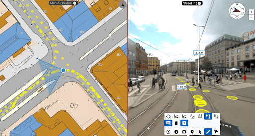
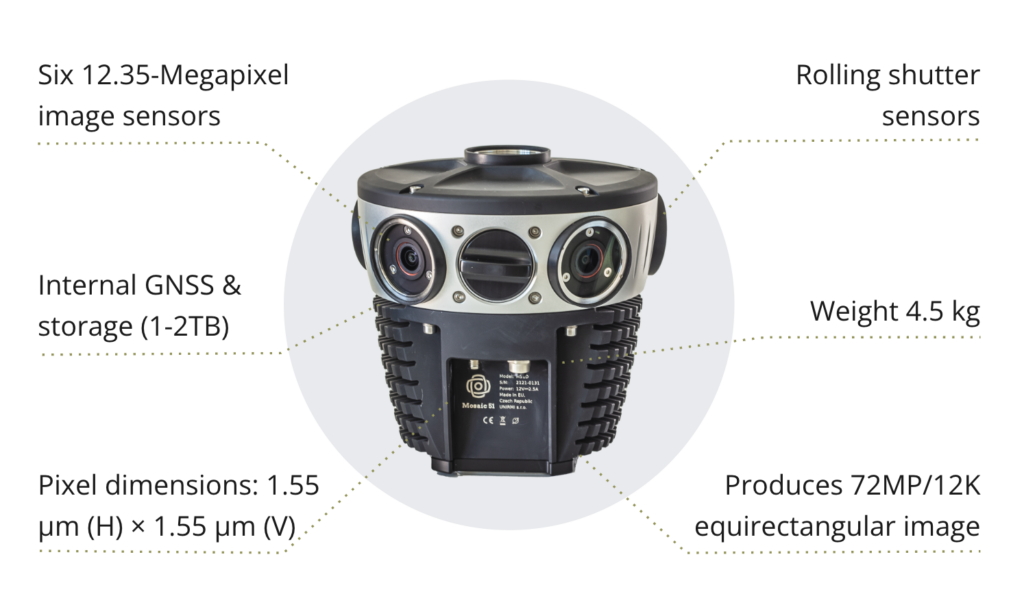
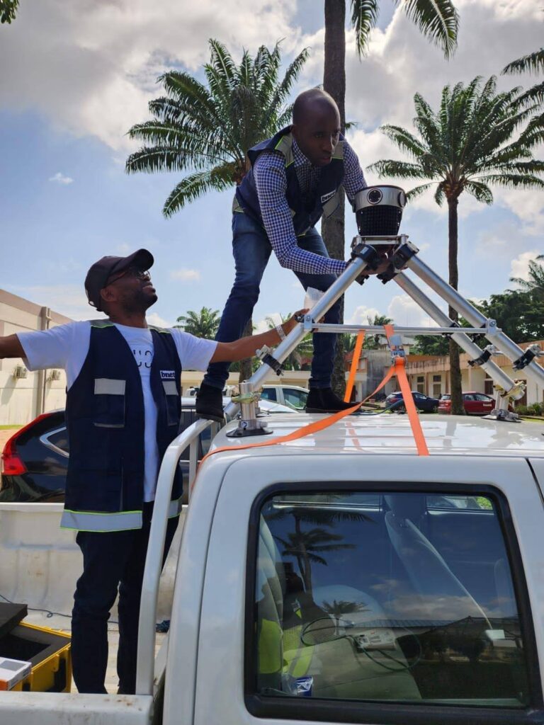
Mosaic’s role in PLACE’s mission is to provide the hardware necessary to produce ultra-high-resolution ground imagery. The Mosaic 51 camera system is ideal for this role because it is a rugged 12.3K panoramic 360° camera designed for mobile mapping, surveying, and infrastructure inspection.
Together, PLACE has already captured 2,378 kilometers of street-level imagery using the Mosaic 51 across five locations (with more to come – stay tuned!):
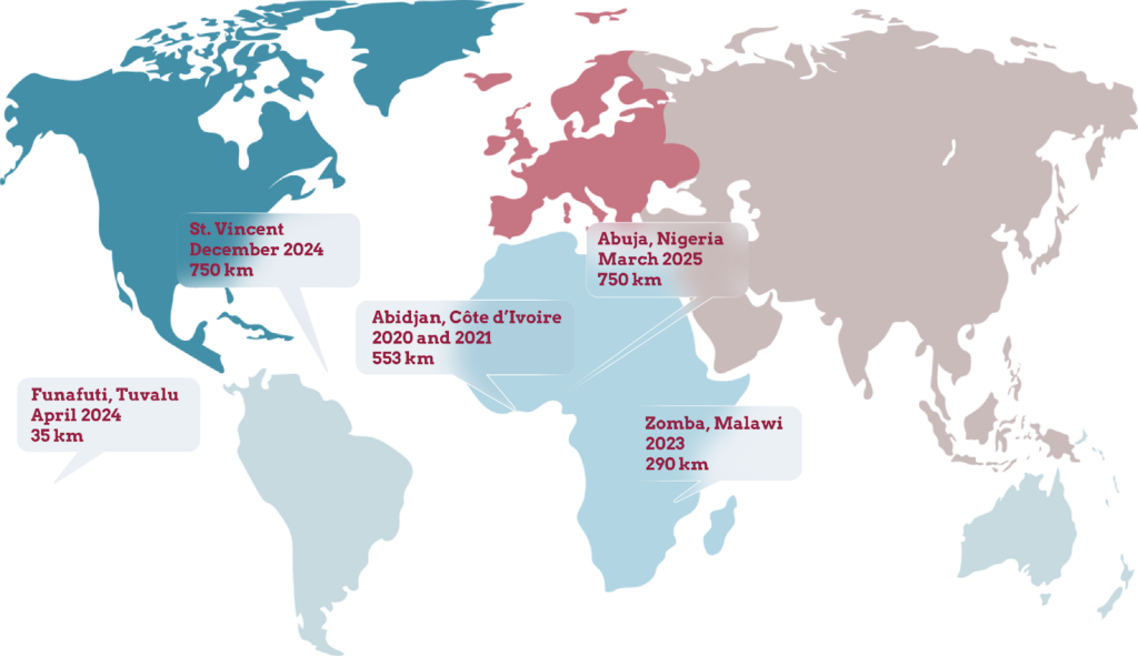
This marks the foundations for modern cadastral systems, fairer taxation, better historical records, and, in the case of Tuvalu, the cultural memory of a nation that may physically disappear.
PLACE’s business model
PLACE describes itself as a “mapping data trust” rather than a typical data vendor. The model is simple in concept and sophisticated in execution. PLACE works directly with national governments to capture high-resolution aerial and street-level imagery at no cost to the government. This is usually through official national mapping or contracted surveying agencies.
The government then owns the data outright, and PLACE deposits a licensed copy into its UK-based data trust that holds it in perpetuity for the public interest.
For outsiders to access the data, organizations (such as universities, NGOs, and private companies) can apply to become PLACE members. They must go through a vetting process to ensure the safety and privacy of local communities. Then, for a modest annual fee, organizations can access mobile mapping data for non-commercial use, subject to clear guidelines and accountability. This structure tackles several long-standing problems at once:
- Long-term access and project sustainability: Many donor-funded mapping projects end when the grant ends. PLACE’s data trust keeps the data alive and discoverable for users outside of a grant’s scope or timeline.
- Sovereignty: The root intellectual property stays with the country, not with an external contractor. This is especially important for the privacy of the local communities and for building trust between mobile mappers, governments, citizens, and private industry.
- Ethics and privacy: Because PLACE works through vetted institutional members rather than putting everything into an open-source data storage site, they can better balance transparency with the very real risks of exposing vulnerable communities via high-resolution street-level imagery.
For the Mosaic 51, this means the data it captures does not sit on a single hard drive in a forgotten office. It becomes part of a living, governable data asset that can support everything from cadastral reconstruction to climate-migration research.
Why Mosaic 51 is a good fit for PLACE missions
Many PLACE deployments happen in environments where you don’t necessarily get a second chance. Logistics can be extremely constrained. For example, Tuvalu had no aviation fuel for months, meaning equipment couldn’t be flown in until fuel tanks were refilled. On remote islands, ferries run out of fuel or get delayed for days between islands. Once on land, you also have to consider the road quality, heat, salt spray, and humidity that can push the limits of the hardware.
The Mosaic 51’s rugged design is exactly what PLACE needs.
- Its rugged industrial housing and connectors have been IP-67 tested against water, dust, heat, and vibration. It is suitable for driving long days on rough roads.
- The Mosaic 51’s standalone architecture with onboard GNSS means a single operator can drive and capture all day without a dedicated in-car workstation. It also doesn’t require specialized training.
- A 1–2 TB internal storage means you can forget about switching out 6 micro-SSD cards several times a day on the side of the road.
- A non-vendor-locked data format, which fits PLACE’s ethos of reusability. Non-proprietary data lets governments and their partners process imagery in ArcGIS Reality, other GIS tools, or custom AI pipelines as needed.
PLACE also operates in a mixed-sensor environment, combining aerial imagery, photogrammetric 3D, and street-level data. With such a diverse client base, different projects often have different needs. Mosaic’s ability to integrate with external GNSS/IMU and LiDAR systems fits neatly into this multi-modal world.
“With the Mosaic camera, the PLACE team is able to efficiently capture the high-resolution imagery and positionally accurate data our members require. We’ve worked with a range of cameras over the years, but the ability to collect quality data at any speed, regardless of weather and changing light conditions, and in a solid hardware package that can handle occasional branches, sets the Mosaic camera apart. Combine the equipment with first-rate support from the Mosaic team, and I don’t see us using a different camera for primary data collection.”
– Frank Pichel, Managing Director at PLACE
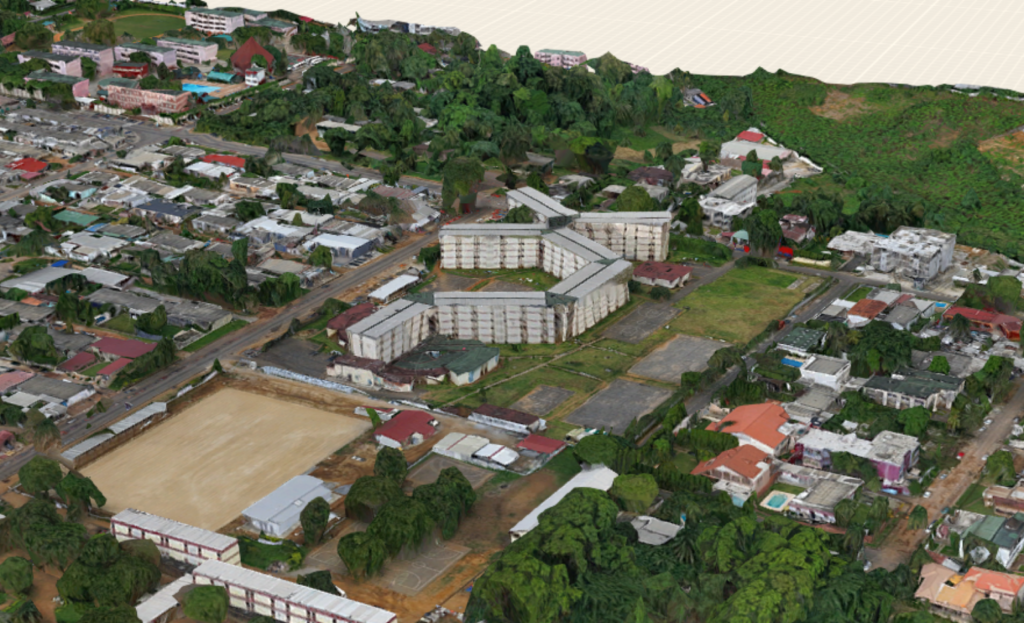
Abuja, Nigeria: Smart cities start with cadastral ground truth
Abuja is one of the fastest-growing cities in Africa, with about 35% annual population growth as of 2015. It is the capital of Nigeria and one of the wealthiest capitals on the continent. During its rapid growth, development sprawled, informal settlements expanded, and cadastral maps drifted further from reality.
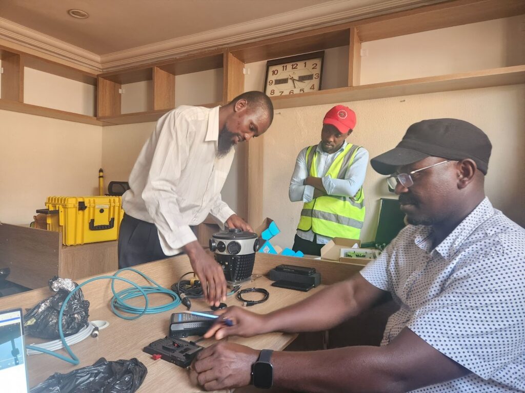
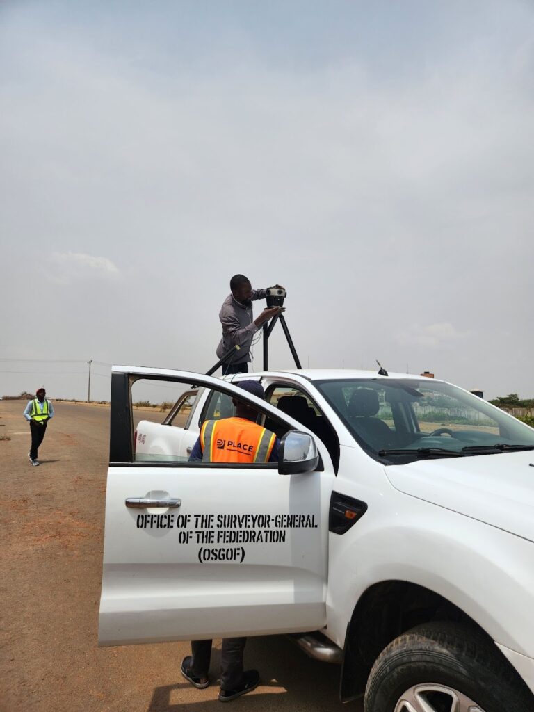
In March 2025, PLACE and Nigeria’s Office of the Surveyor-General of the Federation (OSGOF) deployed a Mosaic 51 in Abuja, capturing over 700 km of city streets. The imagery then went through ArcGIS Reality and GeoAI workflows. The overall goal of the work is to extract building footprints and settlement patterns to better manage the rapidly growing city.
For Abuja, high-resolution street-level imagery is not a luxury. It helps city officials manage critical tasks across many departments:
- Cadastral verification and property tax assessment: Tax authorities can cross-reference 360° imagery against land registry maps to verify building footprints, spot unregistered extensions, and flag mismatched land-use classifications. This directly feeds into fairer, more complete tax rolls, which are a critical revenue source for rapidly growing cities.
- Land-use planning and infrastructure auditing: Urban planners and engineers can remotely inspect road conditions, drainage, signage, and encroachment without sending field crews out for every site visit. They can also use the imagery as “ground truth” to validate AI-derived datasets.
- Inter-agency collaboration: Because Mosaic 51’s data is non-proprietary and easy to integrate into existing GIS workflows, OSGOF can share one dataset across multiple ministries. As an infrastructure investment, it was important for Mosaic 51’s data to work with agencies as diverse as transportation, utilities, and emergency management without complex licensing agreements or red tape.
PLACE’s role is to ensure that this imagery doesn’t remain a one-off project. By placing a licensed copy in the data trust, Abuja’s streets become part of a long-term asset that can be revisited, reprocessed with new AI methods, and compared over time as the city continues to change.
Check out our detailed case study here: Building Smart Cities in Nigeria
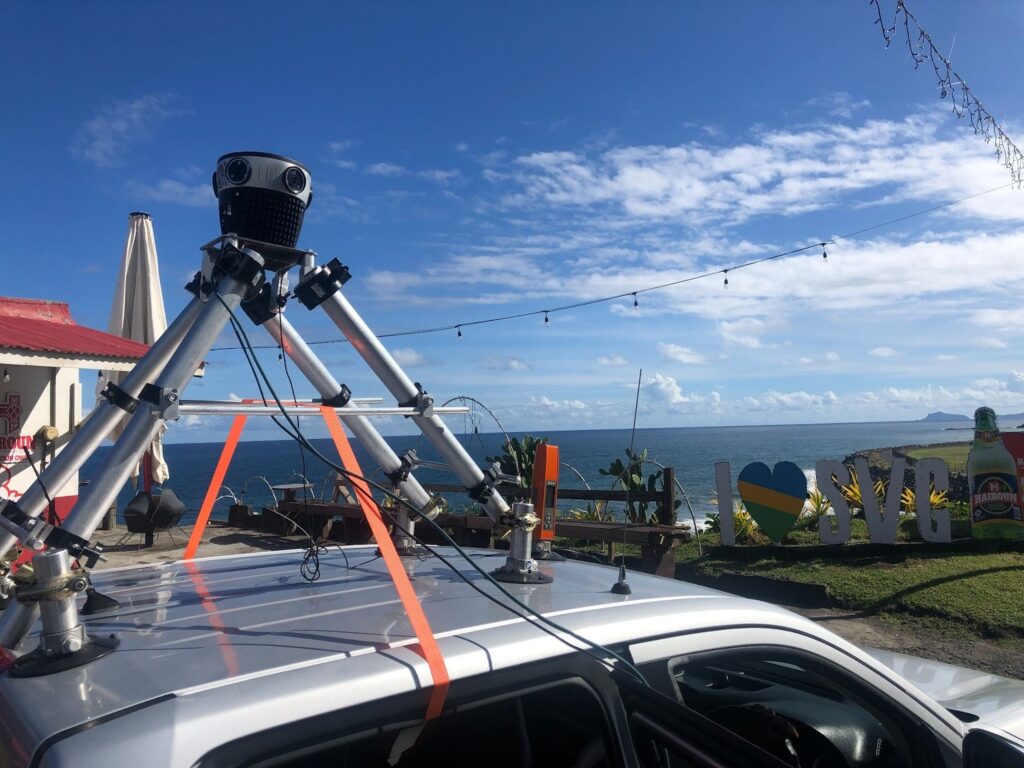
Funafuti, Tuvalu: Mapping a nation that’s sinking
Tuvalu is one of the world’s most vulnerable countries to sea-level rise. Its population is only around 12,000 and is spread across narrow atolls. Yet it has become a test case for questions that international law hasn’t fully answered:
What happens to sovereignty, citizenship, and culture when your land becomes uninhabitable or disappears?
PLACE’s Tuvalu project combines aerial imagery with street-level data in a technically sophisticated way. One early use case concerned water security. Tuvaluan authorities used aerial imagery to locate water tanks, then the street-level imagery helped estimate their dimensions. This helped officials model potable water storage capacity across the country and identify capacity and coverage gaps. Another use case was coastline capture to create a visual baseline for tracking coastal erosion and inundation from king tides.

Beyond the practical GIS applications, Tuvalu has explicitly framed this work as part of its digital twin strategy. They need a way to preserve a representation of the country even if much of its land becomes submerged and uninhabitable. Its leaders have asked the international community to continue recognizing Tuvalu’s sovereignty even if its territory is largely underwater, with the digital twin as one visible anchor for that claim.
In that context, a rugged 360° camera surviving salt spray and tropical heat is an absolute necessity.
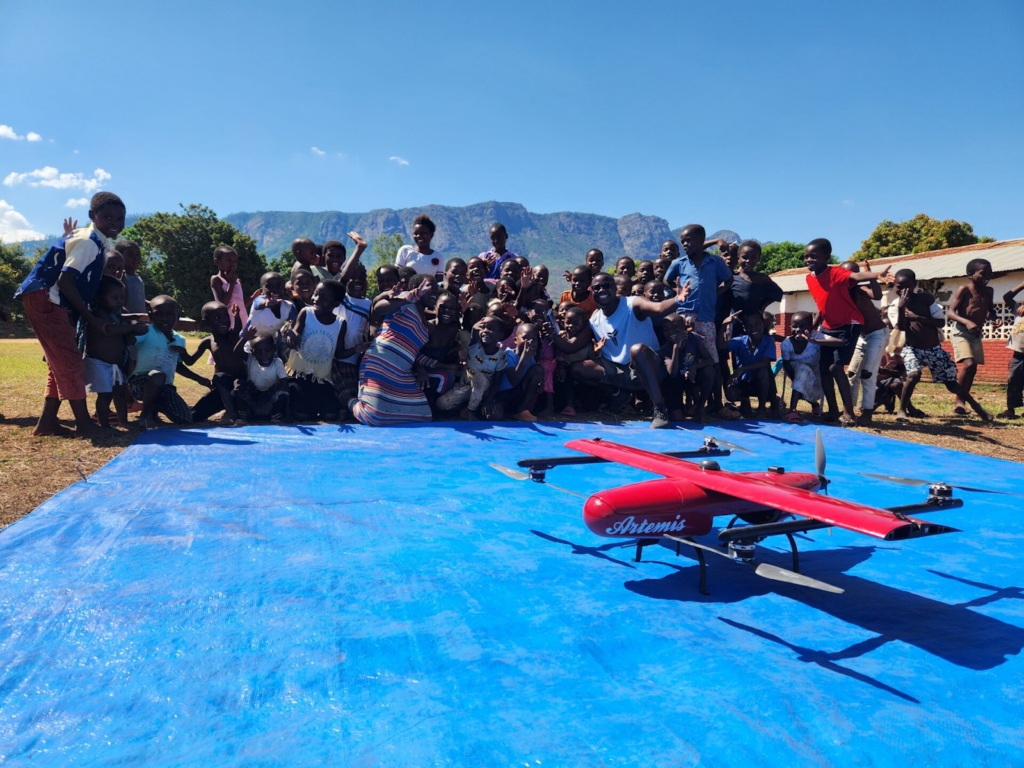
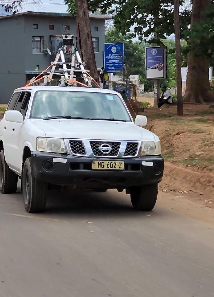
Zomba, Malawi: Local training for grassroots infrastructure
In Malawi, PLACE partnered with the Department of Surveys, a division of the Ministry of Lands, to capture high-resolution data in Zomba and Lilongwe. A 3D model of Zomba, based on imagery captured in December 2023, features prominently on PLACE’s homepage.
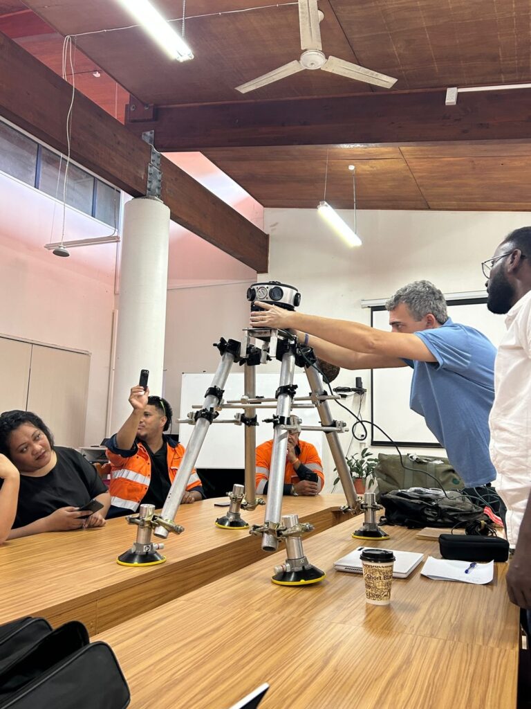
PLACE puts a lot of emphasis on training local teams of surveyors whenever possible, and for this project in Malawi, they trained 11 local staff on the technology and concepts behind mobile mapping. The locally-trained teams captured 290 km of Zomba streets with the Mosaic 51 in 2023. Instead of importing staff from abroad, PLACE added to the local knowledge base of these technologies and improved local relationships.
In a city like Zomba, the same dataset can serve several overlapping needs:
- Modern cadastral maps: Many city streets in emerging economies are recorded in hand-drawn maps or incomplete digital records that can be decades old. Street-level imagery gives surveyors a reality check: does the building on the ground match the parcel boundaries and declared land use?
- Property taxation: With better feature extraction, such as recognizing the facade type, number of stories, and new additions to the original property, tax authorities can make assessments that better match the actual property value.
- Urban historical records: When Zomba updates its model a decade from now, today’s imagery will become a historical record. Researchers will be able to “walk” the streets of 2023 to compare the changes in shopfronts, building density, and informal structures.
Abidjan, Côte d’Ivoire: Pre-flood interventions
Abidjan, Côte d’Ivoire, was one of PLACE’s earliest African deployments with the Mosaic 51. Back in 2020 and 2021, their team captured high-resolution street-view imagery of over 553 km of streets. As in Abuja, Nigeria, the city’s growth has outpaced traditional mapping cycles and methods.
Abidjan is a coastal city and is therefore highly prone to flooding. During the country’s rainiest month, June, Abidjan receives about 8.6 inches of rain. The main goal of this mobile mapping project was to collect data about vulnerable areas to prevent future fatalities and infrastructure damage.
Abidjan’s early adoption also helped PLACE refine workflows for subsequent African cities: training local staff, managing large data transfers, and building repeatable relationships between national survey departments, PLACE’s global team, and the Mosaic hardware.
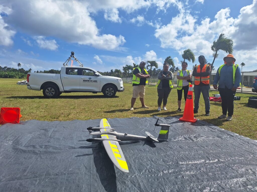
St. Vincent and the Grenadines: a strong foundation to build upon
In December 2024, PLACE joined forces with the Caribbean Digital Transformation Project to capture approximately 750 km across St. Vincent and the Grenadines. The Mosaic 51 provided high-resolution street-view imagery, while a fixed-wing drone captured aerial imagery.
This project is for the Lands and Surveys Department, as part of the Ministry of Transport, to simplify land transactions and improve decision-making. The last data capture of this type was conducted in 2007, so the new imagery will be a huge improvement on their current resources.
Uses for mobile mapping beyond maps
On the surface, these projects are about maps: basemaps, 3D city models, and digital twins. Underneath, several deeper themes run through every project in which PLACE uses the Mosaic 51.
1. Fairer property systems and taxation
Cadastral layers and tax rolls are only as good as their underlying data. Outdated or incomplete imagery disproportionately harms citizens whose properties are undervalued or misclassified. This can lead to expensive disputes and bureaucratic delays. Additionally, local governments lose revenue due to unregistered construction or informal expansions that go unnoticed.
2. Climate adaptation and cultural preservation
Tuvalu is the most dramatic case, where street-view imagery feeds both water-security modeling and an existential conversation about what it means to be a country without habitable land. But climate stress shows up elsewhere, too. Caribbean islands are also balancing tourism, human development, and hurricane exposure. Meanwhile, African cities are dealing with flooding due to inadequate drainage and rapid, unplanned expansion.
In all of these cases, reliable, repeatable imagery is a prerequisite for serious climate adaptation planning.
3. Reducing geographic bias in AI models
PLACE openly acknowledges that many computer-vision models used on geospatial imagery were originally trained on places like San Francisco, not on Abuja, St. Vincent, or Tuvalu. Each new campaign adds thousands of images from underrepresented locations into training datasets. This improves tools such as object detection systems for buildings, vegetation, and street infrastructure in these contexts.
That matters for cadastral AI, but also for any global application that claims to “understand” the built environment worldwide. Without imagery from all of the diverse places we call home, the AI simply won’t see those parts of the world.
The quiet power of durable hardware and deliberate governance
PLACE explicitly highlights that governments can use this data to decide “where and how much to invest to serve citizens.” In contrast, civil society uses it to monitor change and hold institutions accountable. Mosaic’s role is to design hardware that makes the street-level component of that dataset as complete and reliable as possible, even when roads are rough and conditions are unpredictable.
It’s tempting to focus purely on the technical glamour of these projects, but none of it works without two key ingredients:
Field hardware that keeps working
PLACE’s teams have described ferries running out of fuel, multi-week travel chains to remote places, and months-long waits for aviation fuel. In those conditions, cameras cannot be fragile. Mosaic 51’s robust housing, IP-67-tested structure, and proven performance in extreme heat and humidity make it a sensible choice for missions where failure is not an option.
Governance that respects sovereignty and openness
PLACE’s data-trust model is intentionally neither traditional open-source data nor a closed corporate silo. Governments retain ownership and control, vetted members gain access, and usage is tracked to protect vulnerable communities while still enabling research and innovation.
For Mosaic, the collaboration with PLACE is a validation that rugged, vendor-agnostic 360° cameras have a role far beyond traditional street-view or commercial asset inspection. They are becoming instruments of fiscal justice, climate resilience, and cultural memory in some of the most overlooked corners of the map.