
ARX Technology originally published this article in April 2025.
Efficient urban infrastructure management represents one of the greatest challenges for public administrators and essential service companies.
Posts, signs, traffic lights, fire hydrants, manholes, distribution networks, and countless other elements make up a complex ecosystem that requires constant attention, maintenance, and updating.
Traditionally, recording and monitoring urban assets relied on manual, time-consuming, and inaccurate processes. Field teams have had to walk the streets with clipboards, forms, and, more recently, tablets, to record information about each element of the infrastructure. This process, in addition to consuming considerable time and resources, often resulted in incomplete or outdated data.
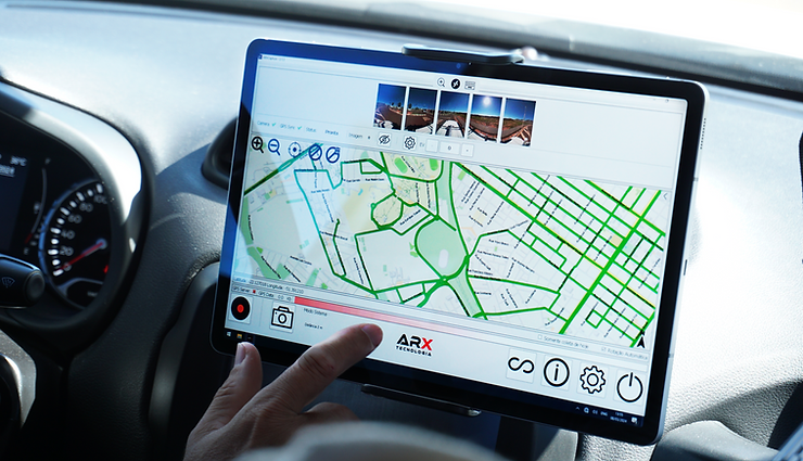
In this scenario, 360° mobile mapping is emerging as a transformative technology capable of revolutionizing how we manage urban infrastructure. In this article, we will explore how advanced mapping systems like the ARX 672, combined with specialized software like ARX Geo 360, are redefining the standards of efficiency, accuracy, and cost-effectiveness in urban asset management.
The Challenges of Traditional Urban Infrastructure Management
Before we dive into technological solutions, it is important to understand the challenges faced by urban infrastructure managers:
Complex and Costly Initial Registration
The first challenge begins with the initial registration of assets. In medium and large cities, we are talking about tens or hundreds of thousands of elements distributed across large geographic areas. Traditional registration requires:
- Large teams to cover the entire territorial extension;
- Weeks to months of field work;
- High costs for personnel, transportation, and equipment; and
- Specific training for the standardization of data collection.
Difficulty in Keeping Data Up-to-Date
Once the initial registration has been completed, keeping the data updated becomes a constant challenge because:
- New elements are installed regularly;
- Existing assets are removed or replaced;
- Physical conditions of elements change over time; and
- Changes in the environment may affect the functionality of assets.
Data Inaccuracy and Inconsistency
Traditional methods often result in:
- Variations in the quality of data collected by different teams;
- Inaccuracies in the georeferencing of assets;
- Incomplete information about physical characteristics; and
- Difficulty in documenting the spatial context of the surroundings.
Inefficiency in Decision Making
With inaccurate or outdated data, managers face difficulties in:
- Planning efficient preventive maintenance;
- Prioritizing interventions in critical areas;
- Optimizing resource allocation; and
- Responding quickly to emergency situations.
How 360° Mapping Transforms Infrastructure Management
360° mobile mapping represents a paradigm shift in the way we collect, analyze, and use urban infrastructure data. Using systems like the ARX 672, it is possible to capture high-resolution (72MP) panoramic images that are precisely geotagged. This creates a complete visual record of the urban environment.
Rapid and Comprehensive Data Collection
One of the main advantages of 360° mapping is the speed and scope of data collection:
- A single vehicle equipped with the ARX 672 system can map tens of kilometers of roads per day;
- All images are automatically georeferenced with centimeter precision thanks to the integrated GNSS/IMU system;
- The Mosaic 51’s 72 MP resolution allows you to identify minute details of urban assets, such as property numbers, for example; and
- The process is non-invasive and does not interfere with the normal flow of the city.
Creating a Complete Visual Inventory
Unlike traditional methods that only record specific data for each asset, 360° mapping creates a complete visual inventory because:
- Each element is captured in its spatial context;
- Panoramic images allow not only visualization of the entire surroundings, but also direct measurement and registration in the 360º panorama;
- It is possible to “revisit” virtually any location at any time; and
- The visual record serves as a baseline for future comparisons.
Accurate Measurements Without Field Visits
With ARX Geo 360 software, it is possible to take measurements directly from panoramic images of various assets, such as:
- The height of posts and structures;
- Distances between elements;
- Dimensions of signs and signs;
- The width of roads and sidewalks;
- Or any other visible asset.
You can do all of this without the need to send teams to the field, saving time and resources.

Efficient Asset Identification and Registration
360° mapping combined with ARX Geo 360 software allows your team to:
- Visually identify each element of the infrastructure;
- Automatically georeference each asset;
- Classify elements by type, condition, and characteristics; and
- Create a complete, accurate, and customized database.
Integration with Existing Management Systems
The data collected with the ARX system can be easily integrated into existing management systems (GIS), as it allows you to export GIS (Geographic Information Systems) compatible formats.
Practical Use Cases of 360° Mapping in Infrastructure Management
Public Lighting Management
Public lighting is an essential component of urban infrastructure, directly related to the safety and quality of life of citizens. 360° mapping allows:
- Precisely register each lighting pole;
- Record the type of light fixture, power, and technology used;
- Identify areas with poor lighting;
- Plan upgrades (such as LED replacement) based on accurate data; and
- Monitor the physical condition of poles and luminaires.
We recorded a successful use case in a city in the interior of São Paulo, which used the ARX 672 system to map its entire public lighting network in just two weeks. This process would have taken months using traditional methods. With the data collected, among the actions taken, it was possible to identify priority areas for replacing conventional lamps with LEDs, resulting in energy savings and improved lighting quality.
Road Signs and Traffic Safety
Efficient management of road signs is essential for road safety. With 360° mapping:
- All signage is accurately catalogued;
- It is possible to check the visibility of the plates from different angles;
- Damaged or vandalized signs are easily identified;
- Compliance with norms and standards can be verified remotely;
- Planning new signage becomes more accurate and faster; and
- You can identify asphalt blanket quality.
Another successful example of the use of the ARX system was by a highway concessionaire, which used 360° mapping to create (among other records) a complete inventory of signage on 150 km of roads.
The process identified 87 damaged signs that needed immediate replacement and 134 locations where vegetation compromised the signs’ visibility, allowing for rapid corrective actions that significantly increased road safety and ensured compliance with the concessions’ conservation laws.
Distribution Network Management
Utility companies such as electric power, telecommunications, and natural gas can benefit greatly from 360° mapping through the following:
- Accurate registration of poles, transformers, and equipment;
- Identification of conflicts between different networks;
- Verification of safety distances between networks and buildings;
- Expansion planning based on complete visual data;
- Rapid damage assessment after extreme weather events; and
- Verification of vegetation interference with the electrical grid.
The Energisa Group (energy distribution company) in Brazil uses the ARX 672 system to map vegetation interference in its network in urban areas. With the data collection, it is possible to identify all possible interruption points due to the proximity of vegetation, prioritize preventive pruning, and ensure the continuous operation of the network much more efficiently than would be possible with traditional inspections.
Urban Drainage Management
Drainage systems are critical to preventing flooding and inundation in urban areas. They require a lot of maintenance, such as:
- Accurate registration of manholes, storm drains, and galleries;
- Identification of obstruction or damage points;
- Planning preventive cleaning in priority areas; and
- Analysis of system capacity in relation to urbanization.
The city government of the metropolitan region of São Paulo used 360° mapping to create a complete registry of its urban drainage system. With this data, it was possible to identify critical areas where drainage capacity was insufficient and plan preventive interventions before the period of heavy rains. By preparing ahead of time with a mobile mapping camera, they significantly reduced flooding points in the city.
Artificial Intelligence: The Next Step in Infrastructure Management
The combination of 360° mapping and Artificial Intelligence technologies represents the state of the art in urban infrastructure management. ARX Geo 360 software already incorporates AI capabilities for automatic identification of vertical and horizontal traffic signs, simplifying and streamlining the inventory process. These AI capabilities allow large volumes of data to be processed quickly and efficiently, transforming images into actionable information for managers.
Return on Investment: Why Adopt 360° Mapping
The adoption of 360° mapping for urban infrastructure management represents an investment with a significant return:
Resource Economy
- Reduction of up to 70% in the time required to register assets;
- 60% reduction in operational costs of field inspections;
- Optimization of maintenance team allocation;
- Efficient prioritization of interventions based on accurate data; and
- Increased safety for employees who do not need to be physically present on the highway.
Improvement in Service Quality
- Faster response to infrastructure issues;
- Preventive maintenance based on real data;
- Better planning of expansions and modernizations; and
- Greater transparency in the management of public resources.
Sustainability and Resilience
- Better preparedness for extreme weather events;
- Reduction of waste of resources in unnecessary interventions;
- Long-term planning based on reliable data; and
- Historical documentation of the evolution of urban infrastructure
How to Implement 360° Mapping in Your City or Company
ARX Technology offers different methods for implementing 360° mapping in infrastructure management:
Systems Sales
For organizations that want to have complete autonomy in the mapping process, ARX Tecnologia offers the complete ARX 672 system:
- High resolution cameras (72 MP);
- Integrated GNSS/IMU system for centimetric georeferencing;
- ARX Geo 360 software for measurement and registration;
- Complete training for operation and maintenance
Flexible Rental
For specific projects or organizations that prefer an operating cost model:
- ARX 672 system rental from 15 days;
- Flexibility to meet seasonal demands or specific projects;
- Complete technical support and project monitoring throughout the entire period of use; and
- The system is always updated.
Specialized Services
For those who prefer to outsource the entire process:
- Collection of 360° georeferenced images by specialized teams;
- Data processing and analysis;
- Delivery of customized reports; and
- Integration with existing systems via Dynamic Link Libraries (DLL).
Conclusion: The Future of Urban Infrastructure Management
360° mobile mapping represents a revolution in the way we manage urban infrastructure. By combining high resolution, geospatial accuracy, and advanced analysis technologies, systems such as the ARX 672 and ARX Geo 360 software enable public managers and essential service companies to make more concrete decisions, optimize resources, and improve the quality of services offered to the population.
As our cities become more complex and resources become scarcer, adopting smart technologies for infrastructure management is no longer an option, but a necessity. 360° mapping is not just a technological tool, but a new paradigm that transforms data into knowledge and knowledge into action.
ARX Technology, as a pioneer in the development of 360° mobile mapping solutions in Brazil, is committed to supporting cities and companies in this transformation journey, offering cutting-edge technology with specialized support for each specific need.
About ARX Technology
ARX, based in São Paulo, Brazil, leads in providing cutting-edge geospatial solutions. With a focus on mobile mapping and surveying technologies, ARX is pioneering new methodologies in the geospatial sector. They are a proud partner of Mosaic for the Brazilian market.
About Mosaic
Mosaic builds rugged, professional-grade 360º cameras for use in mobile mapping, infrastructure inspection, and geospatial documentation. Trusted by customers worldwide, Mosaic helps users document environments in HD, bringing clarity to complex urban and industrial environments.
Contact:
Lynn Puzzo, Director of Sales & Marketing
www.mosaic51.com


