")
Discover how the Mosaic 51 improved Fly North’s ground capture capabilities to map 4,500 km of Colombia’s toughest environments.
Fly North: mapping Colombia with high-precision geospatial data
Drone surveying and street view mapping go hand-in-hand. Today, we had the chance to interview Santiago Trujillo, the Chief Technology Officer for Fly North, about his team’s journey to finding the right camera for their street view mapping needs. Fly North was founded in 2011 and is headquartered in Medellín, Colombia’s second-largest city.
Fly North specializes in remote sensing for infrastructure inspection, the oil and gas industries, and precision agriculture for its clients so they can make informed strategic decisions. They have become drone surveying leaders in high-precision 3D terrain and cadastral modeling using photogrammetry and LiDAR.
To deliver reliable geospatial services with guaranteed quality and optimized turnaround times, Santiago’s team has to balance capture speed, data quality, and price.
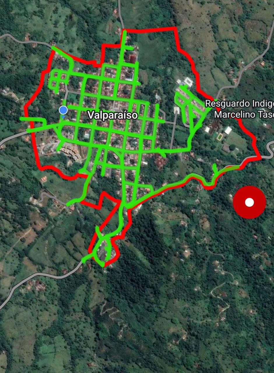
Although Fly North is primarily a drone company, they’ve begun utilizing the Mosaic 51 camera system to capture street-level imagery across 130 towns and cities. This enabled municipalities to update property records, optimize tax revenues, and support urban planning. They mapped a total of 4,500 km in just under 4 months, including data delivery.
“Cadastral mapping is a highly effective tool for cities and governments to update tax records and boost revenue for improvement projects. It’s a win-win solution—once implemented, it essentially pays for itself.”
–Santiago Trujillo, Chief Technology Officer at Fly North
Beyond cadastral applications, the data is also useful in road analysis and energy sector projects, such as mapping utility poles for infrastructure management. Fly North is setting new standards in precision mapping, driving smarter decision-making and sustainable development across Colombia.
Challenges for Colombia’s emerging market economy
Colombia is experiencing steady growth driven by infrastructure development, digital transformation, and increasing foreign investments. This emerging market is Latin America’s 4th-largest economy, and Colombia plays a key role in the region’s development. Its main industries are oil and gas, mining, and agriculture.
Companies in the cadastral mobile mapping and drone-based surveying sectors must navigate this price-sensitive market while maintaining high image quality and effective software to meet industry demands.
Regulatory challenges, fluctuating exchange rates, and import restrictions on high-tech equipment also further complicate the adoption of cutting-edge solutions for mobile mapping and surveying. To remain competitive, drone surveying businesses must prioritize innovation in image quality, optimize hardware-software integration, and explore flexible pricing models catering to the private and public sectors.
Challenges with solely using drone surveying for cadastral projects
While Fly North’s main focus is using cutting-edge aerial drone technology to map urban and rural spaces, drones still have limitations. These challenges make it difficult to generate the comprehensive, high-fidelity 3D models required for urban planning, asset management, and transportation analysis using drones alone.
Gaps in data coverage and accuracy
Drones primarily capture top-down (nadir) imagery, which lacks the necessary perspective for detailed vertical structures, street-level features, and underpasses.
This can lead to incomplete datasets, especially in dense urban areas where tall buildings create occlusions that prevent full coverage of facades and infrastructure. Moreover, aerial imagery alone may struggle to achieve the centimeter-level accuracy needed for high-precision mapping tasks, such as cadastral surveys or infrastructure inspections.
Environmental factors
Strong winds and poor weather conditions can be the difference between a successful drone flight and the loss of expensive equipment. Drones are highly affected by weather conditions such as wind, rain, and fog, which can reduce data quality and limit when and where they can operate.
Limited flight times for drones
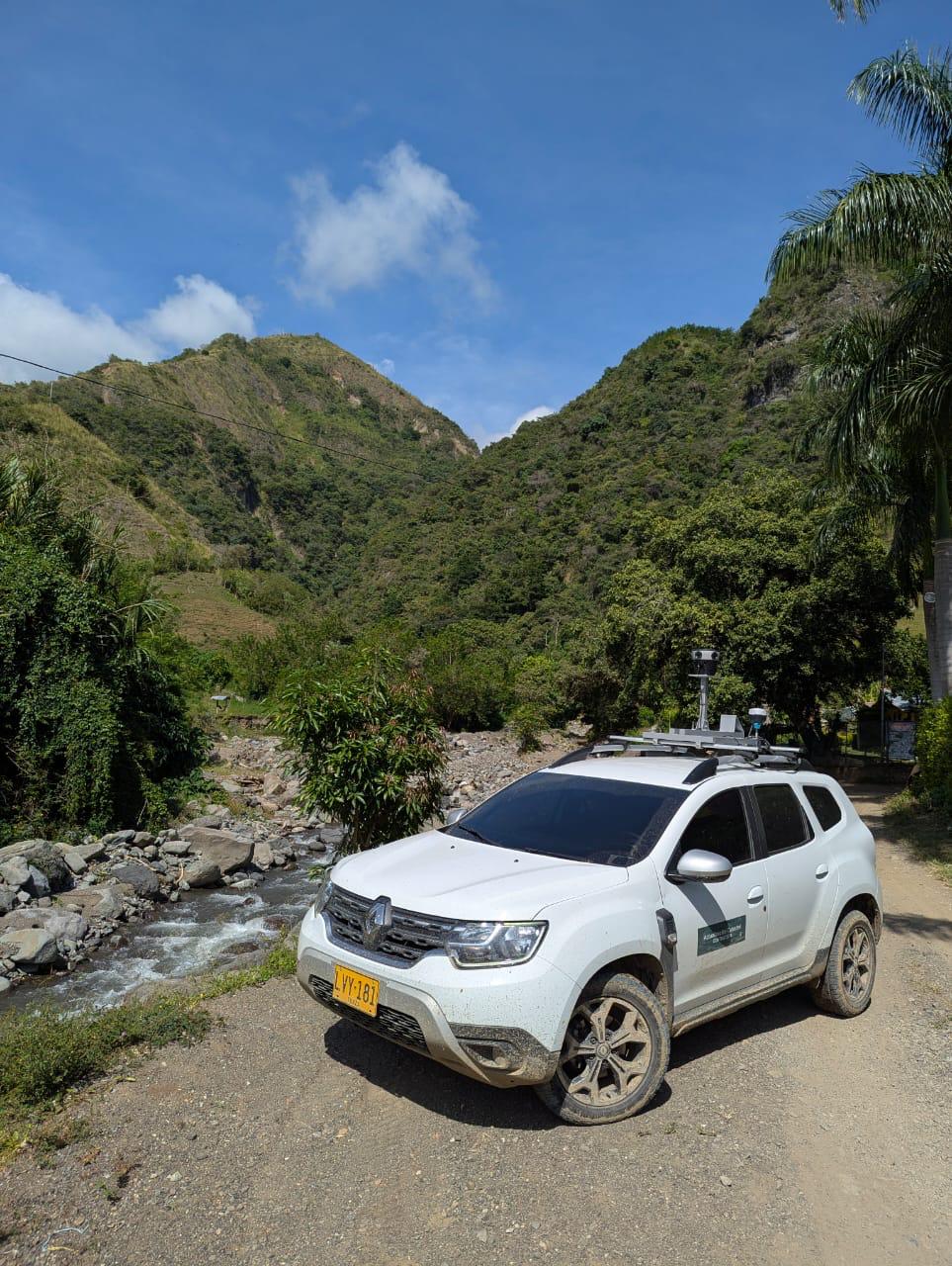
Heavy cameras and batteries with short lives limit how long drones can map in a single flight. These constraints restrict drones’ operational time per flight compared to the time it takes to drive around the same area with the Mosaic 51 camera system.
Legal limitations on drones
Relying solely on drones for mobile mapping presents legal limitations, particularly in urban environments. Many areas have strict no-fly zones, altitude limitations, and licensing requirements that make drone deployment difficult or even impossible.

(Photo by Julien Riedel)
Which 360° camera system pairs best with drone surveying?
Ground-based mobile mapping systems capture high-resolution, georeferenced imagery from a street-level perspective, filling in blind spots left by drones. This approach ensures the detailed documentation of facades, road markings, signage, and infrastructure elements that aerial images alone cannot properly capture.
But not all street view mobile mapping systems are built the same! After testing out the InstaPro 360 2 and inquiring about the Ladybug5, the Mosaic 51 camera proved to be the obvious best choice to complement Fly North’s drone surveying services.

Comparing Insta360 Pro 2 vs Mosaic 51
Fly North had hands-on experience with the Insta360 Pro 2 before transitioning to the Mosaic 51. However, several technical and operational limitations led them to move away from the Insta360 Pro 2.
Insta360 Pro 2 limitations
- Unreliable GNSS tracking: The system had persistent GNSS positioning issues, undermining the accuracy of geo-tagged imagery and complicating the mapping process.
- Thermal performance problems: The Colombian heat was too much for the small camera, and it overheated often during extended capture sessions. This forced operators to pause their fieldwork and wait for the system to cool down. It was inefficient for daily operations.
- Inferior image quality: Compared to Mosaic 51, the Insta360 Pro 2 lacked sufficient resolution and dynamic range for detailed asset capture, especially in urban environments.
Advantages of the Mosaic 51
- Improved mapping accuracy: The Mosaic 51’s GNSS worked much better than the Insta360 Pro 2 and was more reliable in both remote areas with weaker signals and around tall buildings that can block satellites.
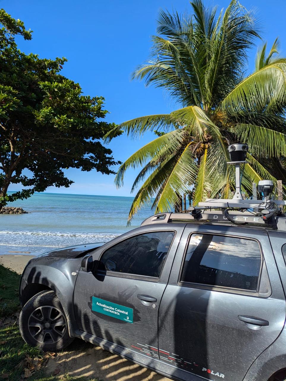
- Rugged design: Field tests confirmed that the Mosaic 51 did not suffer from overheating and still produced clear imagery on bumpy roads. Fly North could perform uninterrupted data collection for many hours across long distances without fear of needing to recapture imagery.
- High-resolution image capture: The Mosaic 51 offered superior visual clarity at 12.3K resolution, allowing for more effective post-processing and accurate documentation of roadways and infrastructure.
Comparing Ladybug5 vs Mosaic 51
Fly North considered purchasing the Ladybug5, a camera system commonly used in high-end mobile mapping. However, its price and complexity posed significant barriers. The Mosaic 51 camera’s value for money, adaptability, and high standard of performance fit the real-world challenges in South America. This positioned the Mosaic 51 as the clear choice over the Ladybug5.
Ladybug5 drawbacks
- High acquisition cost: Fly North also considered purchasing the Ladybug5 before finally deciding on the Mosaic 51. The Ladybug5 was prohibitively expensive for the South American market. It also required costly additional integrations to make it functional compared to the Mosaic 51 camera system’s ready-to-use solutions.
- Accessory requirements: Much of the Ladybug’s functionality depended on integrated components such as IMUs and GNSS systems, which further increased total costs and complexity. As is common with camera-sensor-only solutions, customers need to consider how to trigger the camera, achieve geo-referenced imagery with external devices, and include a powerful workstation in the vehicle to control the capture and store the imagery.
- No clear performance advantage: According to Fly North, there was no significant gain in image quality or operational efficiency that justified the additional expense when compared to the Mosaic 51.
Reasons for selecting the Mosaic 51
- Cost-effective solution: The Mosaic 51 delivered a professional-grade output at a competitive price point, providing a better return on investment for mid- to large-scale projects.
- All-in-one simplicity: The Mosaic 51 camera systems contain a built-in GNSS receiver and internal, hot-swappable storage device. A simple setup decreases possible points of failure and offers a more cost-effective solution than the Ladybug5.
- Established distributor relationship: The company already had a working relationship with Dymaxion, Mosaic’s regional partner in Colombia. This ensured smoother logistics, local support, and trust in the procurement process.
The solution: the Mosaic 51 as a complement to drone surveying
Fly North needed a solution to meet the higher demands of clients on the ground, particularly for projects like cadastral mapping, which required detailed imaging to assess property changes from multiple street view angles. New construction, changes in property usage, street signs, and house numbers needed to be clearly visible in the imagery.
After experimenting with the Insta360 Pro 2 and investigating the Ladybug5, Fly North purchased the Mosaic 51 camera system to complement their drone aerial mapping services. It improved the accuracy and resolution of their cadastral projects while staying within the budget constraints of their Colombian clients.
Mosaic 51’s current use cases in Colombia
Since adding Mosaic 51 with its street view capabilities to its drone lineup, Fly North has been able to more efficiently and accurately meet the needs of its clients. The Mosaic 51 camera is a critical addition to Fly North’s toolbox for:
- Cadastral mapping to help municipalities update property records for tax optimization,
- Street view mapping to capture data for planning infrastructure projects, and
- Energy sector projects, which need high-quality 360° imagery to map utility poles and other assets.
Mosaic 51’s benefits
The Mosaic 51 camera helped Santiago and his team scale their operations to tackle drone-specific challenges for gathering street view imagery in high resolution with its:
Ease of integration and customization: Mosaic 51 worked seamlessly with Flynorth’s existing workflows and GIS software. Santiago’s team could modify processes, such as creating scripts for manual data correction, to fit specific client needs. The camera system works with existing platforms and processes, which was crucial for integration into ongoing projects.
Robustness in challenging environments: Temperatures in Colombia regularly reach 33°C (92°F) in the summer, with high humidity all year round. The Mosaic 51 can capture high-quality imagery in extreme weather conditions without specialized protective equipment and without compromising on quality. This robustness enabled long-term data collection across large areas, which is critical for meeting tight deadlines.
Future Goals
Thanks to the Mosaic 51 camera system, Fly North brought high-resolution, accurate mapping within reach for a South American market that is often constrained by budget limitations and challenging environments.
When asked about Fly North’s future plans, Santiago responded,
“We are exploring advanced road analysis projects, such as identifying potholes, cracks, and road standards compliance, using 360° imagery and potentially integrating LiDAR. These projects will mean faster infrastructure improvements and greater investment in the Colombian market.”
-Santiago Trujillo
Mosaic is proud to be an international presence in the cadastral mapping industry. If you’re ready to complement your drone surveying with street-level mapping, contact us today!


