
Learn each of the pros and cons of satellite vs. aerial vs. drone vs. mobile mapping to unlock the right data capture technique for your environmental assessment and disaster response.
In the realm of environmental assessment and disaster response, the choice between satellite vs. aerial vs. drone vs. mobile mapping imagery is critical. From monitoring large-scale environmental changes to providing real-time insights in the wake of natural disasters, various image capture methods have emerged as invaluable tools for organizations worldwide.
These methods include satellite imagery, aerial imagery, unmanned aerial vehicle (UAV) or drone imagery, and mobile mapping data capture. Each possesses its own unique strengths and capabilities, making them indispensable for a wide range of applications.
Large organizations, in particular, stand to benefit significantly by harnessing the right imaging technology for the right situation and, often, by skillfully combining these diverse data capture methods.
So let’s fly or drive a bit closer and see how each of these data capture techniques stack up against the others.
Satellite Geospatial Imagery
Quick Overview
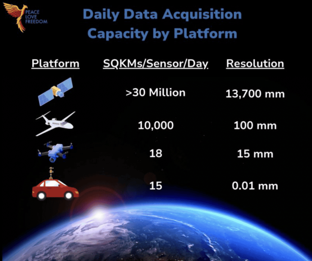
- Captured by: electronic scanners in satellites
- Types include: visible, infrared, water vapor
- Best suited for: wide-scale scientific operations
- Resolution: 30 cm is currently the highest commercially available resolution
- Advantages include: covering a wider area
- Disadvantages include: a lack of flexibility and resolution
What is satellite imagery?
- Captured from satellites orbiting Earth, such as Sentinel-2 and Landsat
- Provides a global perspective
- Images cover large areas but may have lower resolution compared to aerial and drone imagery.
Pros of satellite imagery
- Global Coverage: Satellites can capture images of remote and inaccessible areas worldwide.
- Consistency: Regular satellite passes allow for monitoring changes over time.
- Cost-Effective: Once the satellite is launched, capturing images becomes relatively cost-effective.
- Large-Scale Analysis: Suitable for large-scale environmental, agricultural, and urban planning studies.
Cons of satellite imagery
- Limited Resolution: Satellite images may lack fine details due to their high altitude.
- Weather Dependency: Cloud cover and atmospheric conditions can hinder image quality.
- Limited Real-Time Monitoring: Frequent revisits may be required for real-time observations.
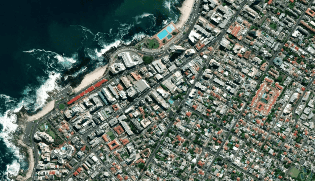
Aerial Imagery from Airplanes & Helicopters
Quick Overview
- Captured by: camera systems attached to airborne craft such as planes and helicopters
- Types include: vertical high and low oblique
- Best suited for: commercial applications across various industries, from construction and real estate to insurance and urban planning
- Resolution: 10-15 cm and can go up to 2.5 cm, depending on application.
- Advantages include: higher detail and more accurate
- Disadvantages include: Weather sensitivity and safety concerns
What is aerial imagery?
- Captured from aircraft flying at various altitudes by agencies, including NOAA and the Civil Air Patrol
- Offers higher resolution compared to satellite imagery.
- More flexible in terms of targeting specific areas.
Pros of aerial imagery
- High Resolution: Aerial imagery provides detailed and sharp images.
- Flexibility: Can capture images on-demand for specific locations.
- Real-Time Data: Suitable for emergency response and immediate assessments.
- Better Perspective: Offers an angled view, aiding in 3D modeling and analysis.
Cons of aerial imagery
- Cost: Aircraft operations can be expensive.
- Limited Coverage: Suitable for smaller areas; coverage depends on flight paths.
- Weather Sensitivity: Flight schedules can be affected by weather conditions.
- Safety Concerns: Requires trained pilots and crew and poses risks during flights.
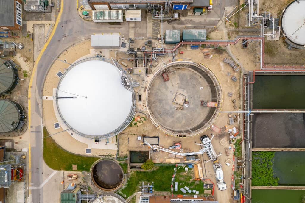
Drones (Unmanned Aerial Vehicles – UAVs)
Quick Overview
- Captured by: Cameras and sensors on unmanned aerial vehicles (drones).
- Types include RGB (visible spectrum), multispectral, thermal, and LiDAR.
- Best suited for: Precision applications that require targeted and up-to-date imagery.
- Resolution: Typically ranges from 1 cm to 10 cm, depending on the drone’s capabilities and flight altitude.
- Advantages include: flexibility and real-time monitoring.
- Disadvantages include: limited flight time and regulations regarding airspace.
What is drone imagery?
- Small, unmanned aircraft controlled remotely.
- Offers high resolution and targeted imaging.
Pros of UAV imagery
High Resolution: Can capture detailed imagery similar to aerial methods.
- Flexibility: Easily maneuverable and can access hard-to-reach areas.
- Cost-Efficient: Generally more affordable than manned flights.
- Real-Time Monitoring: Can provide real-time data for various applications.
Cons of UAV imagery
- Limited Flight Time: Drones have relatively short battery lives, limiting coverage.
- Regulations: Subject to airspace regulations and legal restrictions.
- Skill Required: Operators need training for safe and effective usage.
- Weather Dependence: Wind, rain, and other weather factors can impact flights.
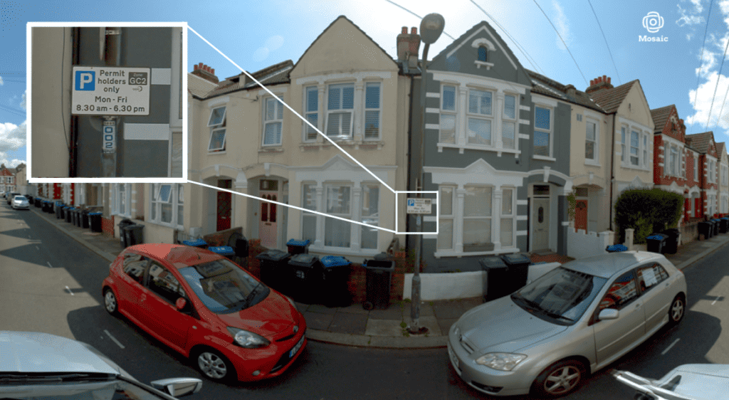
Street View Mobile Mapping
Quick Overview
- Captured by: Cameras and sensors mounted on vehicles, such as cars or vans.
- Types include Street view images, panoramic images, and LiDAR scans.
- Best suited for: Applications that require ground-level visual information and detailed documentation of urban environments.
- Resolution: Street view images typically have resolutions ranging from 2 to 10 cm.
- Advantages include a street-level perspective and fewer restrictions for data capture.
- Disadvantages include limitations due to drivable conditions and privacy concerns.
What is street view mobile mapping?
- Captured from vehicles equipped with cameras and sensors.
- Provides a ground-level view of streets and surroundings.
Pros of street view mobile mapping
- Street-Level View: Offers detailed imagery of roads, buildings, and infrastructure.
- Reveals ground truth data that may not be observable from aerial/oblique imagery.
- Navigation and Maps: Improves navigation applications with visual context.
- Realistic Representation: Useful for virtual tours and visualizations.
Cons of street view mobile mapping
- Limited Coverage: Primarily covers road networks and accessible areas.
- Dependency on Roads: Cannot access off-road or remote locations. (*Combated by mounted on a boat, backpack, or smaller utility vehicle for off-road)
- Data Aging: Images can become outdated as infrastructure changes.
- Privacy Concerns: Can inadvertently capture sensitive information.
Ideal use cases for each data capture technique
Here are the ideal use cases for each of the geospatial data sets: satellite imagery, aerial imagery, drone imagery, and mobile mapping (street view with cars).
Satellite imagery use cases
- Global Environmental Monitoring: Satellite imagery is ideal for monitoring large-scale environmental changes such as deforestation, urban expansion, glacier melt, and desertification.
- Agricultural Planning: Farmers and agronomists can use satellite imagery for crop health assessment, monitoring growth, and identifying irrigation needs over large agricultural areas.
- Natural Disaster Monitoring: Satellite data can track the extent of natural disasters like hurricanes, floods, and wildfires, aiding in disaster response and recovery efforts.
- Climate Change Analysis: By capturing long-term changes in landscapes and ice cover, satellite imagery helps study the impacts of climate change.
- Large-Scale Urban Planning: Using satellite images, Urban planners can analyze city growth, transportation networks, and land use patterns over time.
Aerial imagery (airplanes and helicopters) use cases
- Urban Infrastructure Development: Aerial imagery is useful for planning and developing urban infrastructure projects, such as new roads, bridges, and building complexes.
- Emergency Response: Immediate assessment of disaster-affected areas, like after earthquakes or floods, can be done using real-time aerial imagery.
- Archaeological Site Documentation: Aerial images aid in documenting archaeological sites, revealing hidden patterns and structures in the landscape.
- High-Resolution Mapping: Detailed mapping of small to medium-sized areas, such as university campuses or industrial facilities.
- Environmental Impact Assessments: Aerial imagery helps assess the ecological impacts of construction projects or land development.
Drones (unmanned aerial vehicles – UAVs) use cases
- Construction Site Monitoring: Drones provide up-to-date visuals of construction progress, helping project managers track developments and identify potential issues.
- Search and Rescue: In search and rescue operations, drones can quickly cover large areas, locate missing persons, and assess hazardous conditions.
- Precision Agriculture: Drones can collect high-resolution data for precise crop health analysis, facilitating targeted interventions like fertilization or pesticide application.
- Infrastructure Inspection: Drones can safely inspect hard-to-reach infrastructure like bridges, power lines, and pipelines, reducing the need for risky human intervention.
- Cultural Heritage Preservation: Drones assist in documenting and preserving historical sites, architecture, and cultural landmarks.
Mobile Mapping (street view with cars) use cases
- Navigation and Street View Services: Mobile mapping data enhances navigation apps by providing users with street-level views and visual landmarks for accurate guidance.
- Virtual Tours and Marketing: Real estate agents and tourism industry professionals use street view data to offer properties and destinations virtual tours.
- Retail Site Selection: Businesses use mobile mapping to assess foot traffic, neighborhood demographics, and competitor locations for strategic site selection.
- Local Infrastructure Planning: City planners use street view data to analyze traffic patterns, parking availability, and pedestrian routes for better urban planning.
- Historical Documentation: Street view data captures the historical appearance of streets and neighborhoods, which is useful for documenting changes over time.
Each geospatial data set has its strengths and is best suited for specific applications, making them valuable tools for various industries and projects.
Efforts to combine street-view imagery with aerial imagery
McKenzie Intelligence Services is a London-based geospatial data and imagery analysis intelligence company that specializes in providing innovative solutions for intelligent decision-making. They are renowned for their utilization of satellite, aerial, and drone imagery analysis in commercial applications.
Now, they are collaborating with SiteTour360 to capture ground-level imagery using Mosaic cameras to support their initiative called #CAT360, reinforcing their dedication to delivering unparalleled insights for informed decision-making during challenging circumstances.
Through this partnership, McKenzie Intelligence Services is expanding its capabilities by adding ground-level imagery to its existing space and air-based data sources, offering a comprehensive multi-angle perspective of catastrophic events. The imagery and analysis resulting from this collaboration are now accessible on #GEO for their beta clients, further enhancing their commitment to providing valuable intelligence for clients facing adversity.
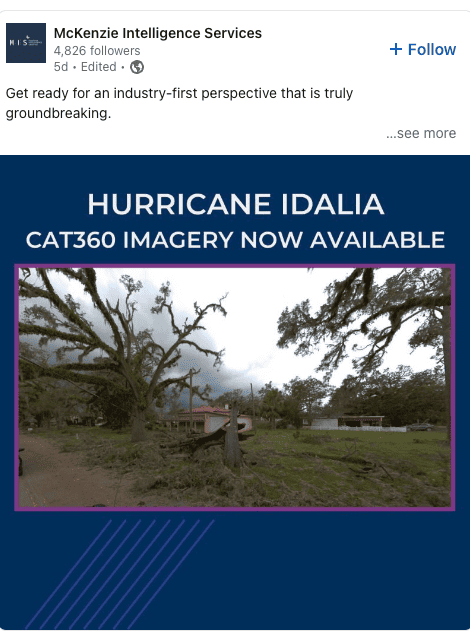
Check out the full story here.
Closing out – where we go from here
A recent podcast titled “Geospatial Support for the UN World Food Programme,” hosted by Daniel O’Donohue and featuring Rohini Sampoornam Swaminathan, discussed key challenges in collecting post-disaster data for disaster response and recovery within the first two weeks of a natural disaster. The podcast highlighted limitations such as cloud cover affecting aerial data collection and the overestimation of drones’ capabilities in terms of coverage and processing speed.
The message emphasized the importance of leveraging a combination of ground-truth data collection methods to enhance disaster response efforts and aid more people in a timely manner. The answer to which method you use depends on the pros and cons of satellite vs. aerial vs. drone vs. mobile mapping.
Check out the full podcast here.
In a world where environmental preservation and disaster management are paramount, the diverse array of image-capture methods at our disposal offers a treasure trove of opportunities. Satellite imagery, with its global reach, proves vital for long-term environmental monitoring, climate change analysis, and large-scale urban planning.
Aerial imagery, delivered from aircraft, excels in commercial applications, providing high-resolution, detailed views indispensable for construction, real estate, and urban planning industries.
UAV or drone imagery takes precision to new heights, offering unparalleled flexibility and the ability to access remote or dangerous locations.
Meanwhile, mobile mapping data capture, with its street-level perspective, aids navigation, virtual tours, and local infrastructure planning.
The strategic use of these image capture methods is where the true power lies. Large organizations can maximize their benefits by integrating and harmonizing data from various sources. Combining satellite imagery’s global context with aerial imagery’s fine detail or coupling real-time UAV imagery with mobile mapping data can provide a holistic view of the environment and accelerate decision-making.
As climate change intensifies and natural disasters become more frequent, organizations that master the art of deploying the right imaging technology at the right moment will not only thrive but also contribute significantly to a more resilient and sustainable future.
Want to talk about how street-level and aerial data could work together for your projects? Contact our team today!


