
Unveiling the secrets of historical data and repeated street view captures. How visual time travel transforms decision-making
An old Confucius says goes something like this:
Question, “When is the best time to plant a tree?”Answer, “Ten years ago.”
Question, “And when is the next best time?”
Answer, “Today.”
Inspired by the above quote (of which there are multiple renditions and is accredited to several sources over the last 50 years), we propose this question to you:
Question, “When is the best time to collect data?”
Answer, “Ten years ago.”
Question, “And when is the next best time?”
Answer, “Today.”
It’s never too late, but why keep waiting? The true value of street view imagery is not just what you see now, but what came before.
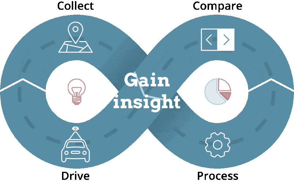
Understanding Historical Data and Repeated Data Captures
As we embark on our exploration of the importance of historical data and repeated data captures, it is vital to grasp the fundamental concepts underlying these practices. Historical data refers to information that has been collected, recorded, and stored over a period of time. It forms a timeline of events, actions, and changes that have occurred in the past, offering a window into the evolution of various phenomena.
Repeated data captures, on the other hand, involve the systematic and regular collection of data at specific intervals or time points. This approach enables the creation of a series of data points, allowing for comparisons and analyses of changes over time. By combining historical data with repeated data captures, researchers, businesses, and policymakers gain invaluable insights into the past, present, and future trajectories of various subjects.
RINSE & REPEAT
The Everlasting Value of Historical Data
In the annals of human history, wisdom has often been derived from understanding past events and drawing lessons from them. Historical data serves as a repository of experiences, revealing the consequences of actions taken in different contexts. By analyzing historical data, we can discern patterns, identify trends, and make informed predictions about potential outcomes.
Learning from historical mistakes and successes is not only relevant to individuals but also crucial for governments, businesses, and societies at large. For instance, understanding how past economic policies impacted nations’ financial health can help guide future fiscal decisions. Similarly, historical data on public health crises can inform preparedness measures and response strategies for future pandemics.
Moreover, historical ‘ground truth’ from street view data often unveils long-term trends that may not be immediately apparent in real-time analyses. By stepping back and examining data collected over extended periods, experts can identify gradual changes and transformations that shape our world in profound ways. These long-range perspectives are invaluable for developing sustainable solutions and adapting to evolving challenges.
Imagery compliments of 360camsters (image data not Mosaic camera data).
Learn more about the 360camsters Private Publisher and our partnership here.
Street View Imagery: A Treasure Trove of Historical Data
In recent years, the proliferation of street view technology has revolutionized our understanding of urban and natural landscapes. Street view imagery, such as that provided by popular mapping services, offers a virtual window into locations worldwide, providing visual information to users at their fingertips. However, this visual treasure trove extends beyond present-day landscapes; it also holds a wealth of historical data.
The process of capturing historical street view data involves carefully preserving and cataloging imagery from previous years. These archives contain snapshots of cities, towns, and rural areas at various points in time, enabling us to witness their transformations over months, years, or even decades. As these street view databases grow, their historical significance multiplies, turning these virtual records into valuable resources for researchers, historians, and urban planners.
By analyzing historical street view data, experts can reconstruct past cityscapes, study the effects of urbanization, and track changes in natural environments. This wealth of information empowers researchers to unravel the intricate relationships between human activities, climate change, and the evolving landscape. Additionally, it allows us to trace the development of infrastructure, observe architectural styles, and understand cultural shifts across different eras.
Beaches and Coastal Regions for Climate Change Assessment
One of the most pressing concerns in today’s world is the impact of climate change on our planet’s natural environments. Beaches, in particular, are highly susceptible to climate-induced changes, such as coastal erosion and rising sea levels. Historical street view imagery provides an indispensable tool for assessing the gradual transformation of these coastal areas.
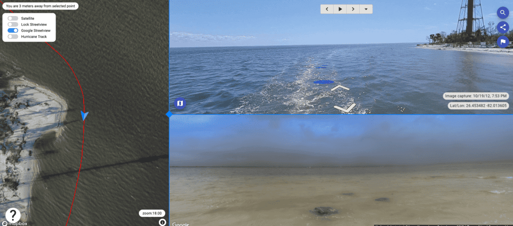
By comparing historical data with present-day street view images, researchers can quantify the extent of beach erosion and analyze how natural landscapes have altered over time. This data enables coastal planners and environmentalists to develop effective strategies for preserving these precious ecosystems and mitigating the effects of climate change.
Moreover, street view imagery captures not only the beaches themselves but also the surrounding flora and fauna. Analyzing changes in vegetation and wildlife distribution can offer insights into how climate change affects biodiversity and ecological balance in these sensitive ecosystems.
Construction Sites – Progress Updates
For construction projects of all scales, accurate documentation of progress is crucial for effective project management and decision-making. Historical street view data combined with repeated data captures can provide a comprehensive visual record of construction sites over months or years.
Project managers can utilize these archives to assess project milestones, track the efficiency of construction processes, and identify potential bottlenecks. By analyzing past projects’ success stories and setbacks, construction companies can implement best practices and avoid repeating costly mistakes.
Furthermore, historical data offers an essential benchmark for evaluating construction progress and ensuring adherence to timelines. This data-driven approach allows for greater accountability, transparency, and client satisfaction in the construction industry.
Road Works – Before and After Projects
Road infrastructure plays a vital role in the development and connectivity of urban and rural areas alike. Undertaking road construction or improvement projects involves significant investment and impact on communities. Historical street view data offers an invaluable resource for planning and assessing the outcomes of such projects.
By conducting before-and-after analyses using historical and repeated data captures, authorities can gauge the effectiveness of road works, including traffic flow improvements and safety enhancements. This information aids in optimizing future road development plans and ensuring the best utilization of resources.
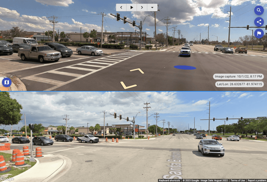
Moreover, road works may also involve the revitalization of public spaces and the integration of green infrastructure. Historical data allows for the evaluation of urban greening initiatives and their long-term effects on air quality, temperature regulation, and community well-being.
Learn how Dymaxion, a Colombian surveying company, utilized a Mosaic 51 camera to capture street view ‘ground-truth’ at the start and end of their road works project.
Vegetation Management – Urban Greenery Progression
As urbanization continues to shape our cities, the importance of maintaining green spaces and managing urban vegetation becomes paramount. Historical street view imagery captures the evolution of green areas, enabling the monitoring of urban greenery progression.
Tracking the growth of trees, parks, and green corridors over time provides valuable insights into the success of urban greening initiatives. It helps city planners assess the impact of planting programs and optimize strategies for maximizing the benefits of urban green spaces.
Discover how Mosaic customer – greehill – is using their Mosaic X camera system to capture street view images of urban greenery.
By combining historical data with repeated street view captures, experts can also evaluate the effectiveness of urban forest management practices. Understanding how different tree species have adapted to changing environmental conditions guides decisions about planting the right trees in the right places for future sustainability.
The city of Denton, Texas, worked with greehill to do a tree inventory and better understand the conditions of their urban forest over time.
Residential Homes and Commercial Facilities for Insurers and Tax Authorities
Historical street view data is an indispensable asset for insurers and tax authorities seeking accurate and up-to-date property information. By comparing past images with present-day visuals, these stakeholders can detect any significant changes in residential and commercial properties.
For insurance companies, monitoring property conditions over time helps assess potential risks and evaluate policyholders’ claims. Historical data aids in identifying pre-existing damages, estimating wear and tear, and determining the need for insurance adjustments based on structural improvements or changes.
Tax authorities, on the other hand, can utilize historical data to identify any unauthorized expansions or alterations to properties. This enables tax assessments to be fair, accurate, and reflective of property changes, discouraging tax evasion and ensuring a just tax system.
The Power of Repeated Data Captures
While historical data provides us with valuable context and insights, repeated data captures add an extra layer of depth to our understanding of dynamic systems. By regularly collecting data at specific intervals, we gain real-time snapshots that allow us to monitor changes as they happen.
Understanding the dynamics of change requires capturing data over various time scales, ranging from monthly to yearly intervals. By doing so, we can identify short-term fluctuations, long-term trends, and cyclical patterns that shape various processes and phenomena.
Capturing real-time snapshots through repeated data collection ensures that the most recent information is always available for analysis and decision-making. This approach enhances our ability to respond promptly to emerging challenges, seize new opportunities, and adapt to ever-changing conditions.
Establishing reliable benchmarks and baselines is another crucial aspect of repeated data captures. By collecting data consistently over time, we can create reference points against which we can measure progress, success, or setbacks. These benchmarks serve as guides for future actions, making data-driven decision-making more effective and reliable.
Maximizing the Benefits: Challenges and Solutions
Harnessing the full potential of historical data and repeated data captures comes with its own set of challenges. The sheer volume of data collected over time poses storage and management complexities, requiring robust infrastructure and data governance protocols.
Ensuring data accuracy and consistency is paramount, as even minor discrepancies can significantly impact the reliability of analyses and subsequent decisions. Implementing strict data quality control measures and validation processes helps mitigate potential inaccuracies.
Leveraging advancements in artificial intelligence (AI) and automation plays a crucial role in efficiently processing and analyzing vast amounts of historical and repetitive data. AI-driven algorithms can identify patterns, trends, and anomalies at a scale and speed unattainable through manual analysis alone.
By investing in cutting-edge technology and developing robust data management strategies, organizations and institutions can unlock the full potential of historical data and repeated data captures.
Ethics and Privacy Concerns in Data Collection
As we delve deeper into the realm of data capture and analysis, we must also address the ethical implications and privacy concerns that arise. Balancing the need for data collection with individuals’ rights to privacy and autonomy is essential in maintaining trust and ethical data practices.
Data anonymization is a critical aspect of protecting individuals’ identities and sensitive information in historical data archives. By removing personally identifiable information, organizations can ensure that data is used for research and analysis without compromising individuals’ privacy.
Obtaining informed consent from individuals whose data is captured is a crucial ethical practice. Transparent communication about data collection and its purposes fosters trust. It also empowers individuals to make informed decisions about sharing their information.
Adhering to industry standards and regulations in data collection and usage is vital to ensure compliance with legal requirements. Organizations should stay informed about evolving data protection laws and implement best practices to safeguard data and respect individuals’ rights.
From Insights to Action: Utilizing Historical Data and Repeated Data Captures
The true value of historical data and repeated data captures lies not only in accumulating information but also in transforming insights into action. Armed with the knowledge and understanding gleaned from these practices, decision-makers across various sectors can make informed choices that positively impact their organizations, communities, and the environment.
Empowering decision-makers with actionable insights enables them to anticipate challenges, recognize opportunities, and adapt their strategies accordingly. Whether in the realms of public policy, urban planning, environmental conservation, or business development, data-driven decisions lead to more effective outcomes.
Driving innovation and sustainable practices is another key outcome of leveraging historical data and repeated data captures. Understanding past failures and successes empowers researchers and innovators to design solutions that address long-standing issues while minimizing negative impacts.
Ultimately, the integration of historical data and repeated data captures into decision-making processes creates a better future for all. By embracing these practices, we honor the wisdom of the past, harness the power of the present, and pave the way for a more prosperous and sustainable tomorrow.
Conclusion
The previously mentioned Confucius quote provides timeless wisdom that resonates deeply in the context of historical data and repeated data captures.
The importance of historical data in offering valuable context, insights, and wisdom cannot be overstated. The interplay between historical data and repeated data captures unlocks a wealth of information that shapes decision-making across various domains.
From monitoring the impact of climate change on natural sites and evaluating construction progress to tracking urban greenery and detecting changes in residential properties, historical data and repeated data captures have far-reaching applications.
To seize the opportunities and address the challenges of the future, we must harness the power of data collected from the past and make use of real-time insights. As we move forward, embracing these practices ensures that we act with foresight, wisdom, and purpose, building a more resilient and sustainable world. It’s never too late, but why keep waiting? The time to act is now.
How you can start collecting (future) historical data
Looking to collect historical data and conduct regular, repeated, and continual street view surveys?
Mosaic produces some of the world’s highest resolution mobile mapping cameras. They are built to reliably collect data in all environments and conditions for months and years on end.

Start collecting data now that will become the historical data you’ll need in the future.


