ARX Technology originally published this article in April 2025.
In the mobile mapping sector, it is common to believe that only laser sensors (LiDAR) can provide high-precision three-dimensional measurements. However, new photogrammetric approaches demystify that view using georeferenced 360° panoramic images.
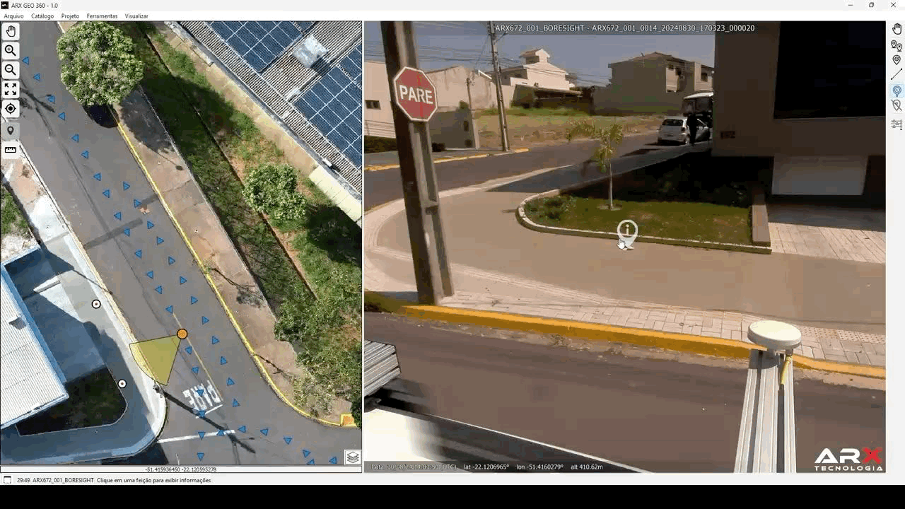
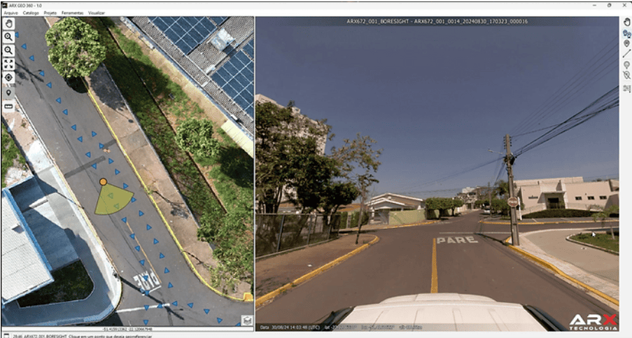
ARX Geo 360º is ARX Technology‘s software developed in Brazil that allows measurements to be made directly on 360° images. This is done through photogrammetric intersection, dispensing with the use of LiDAR.
In this article, we explain how to perform measurements in 360° images with the aid of GNSS/IMU works, highlight the operational advantages of a laser-free approach, and compare their results.
We also discuss in which situations LiDAR is still necessary, present typical use cases (urban mapping, road mapping, and technical cadastre), and how ARX Geo 360º was designed to meet the Brazilian context specifically.
How 360° measurement with GNSS/IMU and photogrammetry works
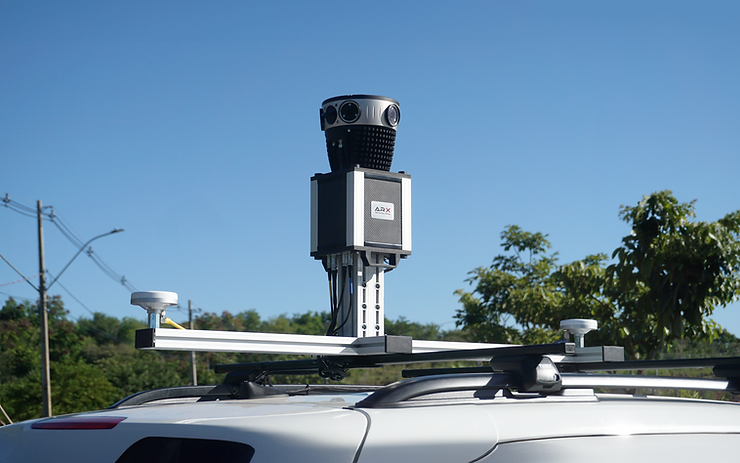
Measuring from 360° panoramic images is based on the principles of classical photogrammetry. In a mobile mapping system such as the ARX 672 (from ARX Technology), a high-resolution digital camera (72 MP) captures spherical images at regular intervals along the route. In contrast, an integrated GNSS (satellite positioning) and IMU (inertial unit) system continuously records the position and orientation of the camera.
Thus, each 360° image is accompanied by precise georeferencing metadata, indicating where and how the photo was taken.
These overlapping images allow for measurements through photogrammetric intersection.
In practice, this means that a point of interest visible in at least two different images can have its three-dimensional position calculated by triangulating the view rays of these cameras.
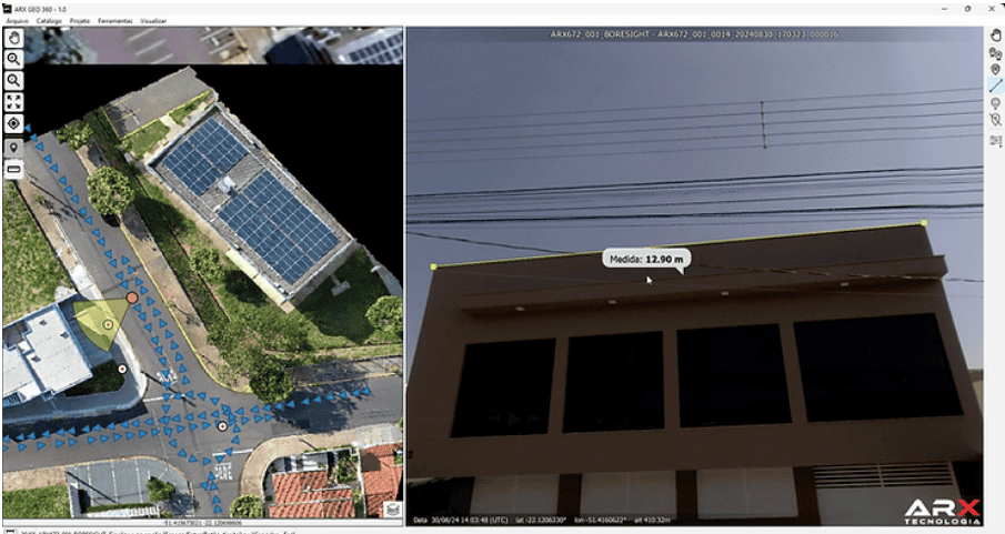
ARX Geo 360º software uses the orientation parameters (from GNSS/IMU) and the camera calibration to project vectors from each image. When selecting the same target (i.e., a pole’s base), it automatically calculates the 3D coordinates of that point by intersection. With two 3D points of an object, it’s possible to measure real distances, such as pole height, sign width, bridge spans, trees, or any other asset, all directly on the 360º panorama.
Photogrammetric accuracy
Thanks to the high resolution of modern 360° cameras and the accuracy of the system’s GNSS/IMU recording, photogrammetric measurements achieve topographic-level accuracy. In practical terms, it is possible to extract coordinates with an error of just a few centimeters. This level is comparable to that of laser surveys. The advantage is that the entire environment around the vehicle is visually documented, allowing the scene to be virtually revisited as many times as necessary.
In short, 3D measurement by 360° image works by combining computer vision and precise georeferencing. The hardware captures the world in geolocated photos, and the software reconstructs distances in space through photogrammetric techniques.
Technical and operational advantages of a laser-free array (LiDAR) approach
Opting for a mobile mapping system without a laser scanner (LiDAR) brings several technical and operational benefits, especially when using a specialized solution such as ARX Geo. Below, we highlight the main advantages:
Simpler and more accessible equipment
Systems with only 360° cameras tend to be more compact and lightweight, making them easier to install in different vehicles. The absence of the LiDAR module (usually an expensive and relatively heavy piece of equipment) significantly reduces the cost of the hardware and the need for specific maintenance. This makes the technology more accessible to companies and city governments, without compromising the quality of the mapping. According to industry studies, the camera can meet the precision demands of most mobile mapping projects while saving a significant amount of investment. In other words, obtain great results with a leaner set of sensors.
Faster operation and easier training
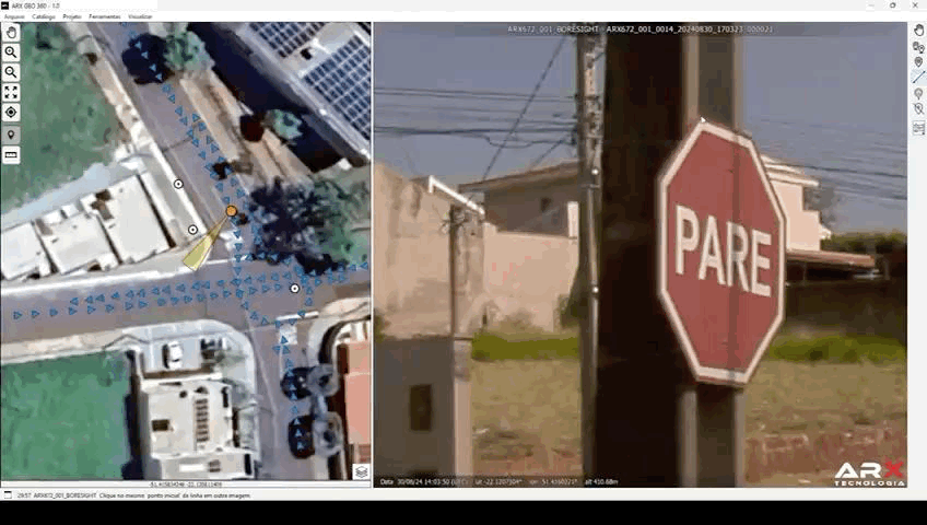
Collecting data with cameras is generally straightforward. Simply drive the vehicle through the area of interest and automatically record images. Do not worry about laser scanning parameters or surface reflectivity; any visible feature is captured in the photo. In addition, training personnel to operate the system and process the photographic data is usually faster. The images are intuitive to interpret. Navigation in software such as ARX Geo 360º is visual and user-friendly. This allows technicians to identify assets and take measurements in the panoramic photo itself.
Data rich in visual information
360° photographs provide a complete visual context of the environment. This is a qualitative advantage over raw laser points. In the image, it is possible to easily recognize the type of object (for example, distinguishing a traffic sign from a lamppost by shape and color), something that in monochromatic point clouds can require greater processing power. This visual richness also favors the use of Artificial Intelligence for automated identification of elements, such as signs and facades, directly in the images. In other words, the photographic database itself already serves multiple purposes (visual analysis, AI detection, illustration in reports) in addition to the measurement itself.
Reducing data volume, costs, and system complexity
An important consequence of capturing visual imagery without LiDAR is the drastic reduction in the volume of data generated and in the costs associated with storage and processing. Laser surveys produce extremely dense point clouds. Millions of points are collected, resulting in large files that require robust infrastructure for handling. Another difficulty of a large volume of data is the exchange of files between the field operator and their collection system (the camera) and the office team.
Mapping based on 360° images generates a significantly smaller volume of data: each panorama is a file (sized in megabytes), and the collection can be configured at intervals (e.g., one photo every 10 meters), according to the needs of each project.
In terms of workflow, image-only data collection simplifies the acquisition process. The photogrammetric processing required to extract measurements is performed automatically or semi-automatically by the software, eliminating the need for cumbersome filtering and point cloud registration steps.
The learning curve for professionals is also shorter: working with photos and maps is part of the daily routine of many GIS teams, while manipulating detailed 3D clouds requires greater technical knowledge.
From a financial perspective, all of these factors translate into operational savings. Less data to store means less investment in servers or cloud services; simpler processes mean fewer processing hours and less skilled labor.
Situations where LiDAR is still necessary
Despite advances in 360° photogrammetry, there are scenarios in which LiDAR technology remains irreplaceable or advantageous: For example, in heavily wooded urban areas, where cameras cannot “see” features through the foliage. In these cases, LiDAR stands out for its ability to capture information at different levels of the vegetation. The energy from the laser pulses partially penetrates the treetops, generating multiple returns that form a detailed three-dimensional point cloud. Therefore, in topography projects of forested areas, densely wooded urban regions, or environmental surveys, the laser scanner is usually the necessary choice to accurately represent the entire structure of the terrain and vegetation.
The good news is that these situations are in the minority of everyday surveys, and, outside of them, 360° cameras do the job with an excellent cost-benefit ratio.
Typical use cases of 360° photogrammetry (urban, road, cadastre)
The mobile mapping approach based on high-resolution panoramic imagery is particularly well suited to many common land surveying scenarios. Here are some typical use cases where ARX Geo 360º and similar systems have been successfully deployed, delivering productivity and accuracy gains:
Urban Mapping and Smart Cities
In the urban context, where there is a wide variety of assets and details on the roads, 360° mapping allows quick cataloging and measuring of infrastructure elements with 360° images. It is possible to identify unregistered constructions or building extensions, assisting in the recalculation of property tax.
Photogrammetric measurement helps to measure setbacks, building heights, and road widths, providing data for urban planning. quickly.
City halls can gather information on traffic signs (signs, traffic lights), urban real estate, paving conditions, and even property facades. A practical example is updating real estate registration with 360° images to identify unregistered constructions or extensions to buildings, helping in the recalculation of IPTU. Photogrammetric measurement helps to measure setbacks, building heights, and road widths, providing data for urban planning.
Road Surveys and Road Inventory
On highways and roads, georeferenced image technology helps in the construction of the inventory and also in the identification and recording of incidents. With the products generated after collecting the highway data, technicians can measure the width of the roadway, evaluate horizontal and vertical signage, identify defects in the pavement, and geographically position elements such as metal barriers, bridges, viaducts, and special works of art. All of this is virtual, without having to return to the field.
The advantage of photogrammetry here is safety and agility. It reduces the time spent by teams on the shoulder collecting points manually, since much of the information is extracted from the images. The precision is sufficient to support engineering projects (e.g., resurfacing planning, road expansion) with time savings.
In addition to these, other areas benefit from this. Railways (mapping of tracks, level crossings, right-of-way), the environmental sector (identification of risk areas, erosion on roadsides visible in images), and civil defense (documentation of scenarios for emergency planning).
In all, the portability and speed of mobile mapping with images allow frequent updates and coverage of large urban areas without prohibitive costs.
ARX Geo and the Brazilian Context
ARX Geo was designed and developed in Brazil by ARX Technology with the aim of meeting the country’s specific mobile mapping demands. This is reflected in several features of the system, making it particularly aligned to the Brazilian context.
Adaptability to local reference systems
From the beginning, the software was designed to work with Brazil’s official projections and geodesy (SIRGAS2000, SAD69 when necessary, UTM, and TM/state Polycônicas projections). This ensures that the measurements taken are ready to integrate with Brazilian municipal registries and cartographic bases without the need for complex conversions. The interface uses coordinates and units familiar to local professionals, speeding up adoption.
Portuguese interface and support for national legislation
ARX Geo has an interface entirely in Portuguese and terminology geared towards Brazilian geotechnology users. In addition, it incorporates concerns with current privacy legislation, such as the LGPD. It offers, for example, native functionality to blur people’s faces and vehicle license plates in images, protecting privacy as required by law. This type of local refinement is not always present in imported solutions and demonstrates ARX’s focus on providing a product ready for use in Brazil.
Developed by Brazilian experts
The technical team behind ARX Geo includes those with master’s and doctoral degrees in Cartographic Sciences, who have graduated from Brazilian universities. They have extensive experience in sensor integration and terrestrial mapping systems. They have applied their knowledge to optimize the software for the conditions found here. For example, when calibrating the 360° cameras under the strong tropical sun, or in testing the robustness of post-processing for complex urban scenarios (with narrow alleys, abundant overhead wiring, etc.).
The result is a tool created by those who understand the local challenges, which translates into greater reliability and adherence to the expectations of national customers.
Partnerships and the local ecosystem
ARX Technology sought strategic partnerships to add value to the system. For example, it is an official partner of Mosaic (a global 360° camera company) in Brazil, combining cutting-edge hardware with ARX Geo software.
It also collaborates with Brazilian institutions and pilot clients to evolve the product based on real field feedback. The software has been tested and refined in mapping projects in Brazilian cities of different sizes. This ensures its adaptability, from registering metropolises to surveying highways in the interior.
Integration with existing GIS systems
ARX Geo offers local support and flexible licensing models (rental, lifetime purchase or integration via DLL into client software). This makes the total cost of ownership more attractive for Brazilian organizations. Compared to importing high-cost foreign systems, this is the economical choice.
In short, ARX Geo 360º represents an innovative Brazilian solution that incorporates the state of the art in mobile photogrammetry, but tailored to the realities of Brazil. For national geotechnology companies, this means access to world-class technology (an alternative to LiDAR) with local support, compatible costs, and tailored functionalities.
Conclusion
The idea that only LiDAR laser systems would be capable of performing high-precision three-dimensional measurements no longer reflects today’s technological reality. Solutions based on georeferenced 360° images, precision GNSS/IMU, and modern photogrammetry have proven to achieve comparable results in a variety of applications, while offering clear advantages in terms of simplicity, cost, and versatility.
ARX Geo 360º software from ARX Technology exemplifies this evolution: a platform that demystifies the dependence on LiDAR, allowing mapping companies to perform accurate surveys directly from panoramic photographs. With it, urban mapping, road mapping, and technical cadastre tasks become more agile and efficient, without losing quality.
It is essential to critically evaluate each project to choose the right technology. In many everyday scenarios – city streets, highways, asset inventories – 360° photogrammetry fully meets the needs. It delivers centimeter-level accuracy and a rich visual basis for analysis. LiDAR remains relevant in specific contexts, like dense forests and complex 3D models. But, it is no longer the only option for reliable measurements.
For the technical audience of geotechnology, it is exciting to have alternatives such as ARX Geo, which combine innovation and local knowledge. This approach reduces barriers to entry and paves the way for more organizations to enjoy the benefits of high-precision mobile mapping, choosing the right tool for each challenge, be it a laser beam or a 360-degree camera.