
The need for speed and high-definition delivered in one solution. Learn more about this case study of an electrical grid inspection
Who is Dymaxion
Another business that has joined the club of customers Mosaic has helped push the boundaries of what they expected from their mobile mapping project is Dymaxion s.a.s. Today, we will examine two mobile surveying projects where Mosaic 51’s design proved capable of a wide range of challenges. These include the requirements for high-definition 360° imaging specific for electrical grid analysis, as well as extreme weather conditions.
Dymaxion s.a.s. is a Colombian engineering company founded in 2011. They focus on applying mobile mapping (including UAV), photogrammetry, atmospheric sampling, and remote sensing (LiDAR) technologies. This combination optimizes data capture times and improves design results for the road infrastructure, power lines, and the energy sectors.
Until recently, LiDAR surveying (geo-referenced point clouds) and photogrammetry (capturing and editing 3D spatial objects from high-definition images) covered their project needs.
The situation was about to change with a challenging 3-year project Dymaxion tendered for and won. We spoke with the CEO, Gustavo Guevara, about accepting the challenges and finding solutions.

Challenge #1: Analyzing the electrical grid on nearly 30,000 kilometers
An electrical distribution company commissioned Dymaxion to map and collect detailed information about nearly 30,000 kilometers of power lines.
“This is really a large scope mobile mapping project. We were about to collect data every day for around 3 years. We had to design a backup solution integrating different technologies to match the data capture to the specifics of the grid analysis.”
Gustavo Guevara, Dymaxion s.a.s. CEO
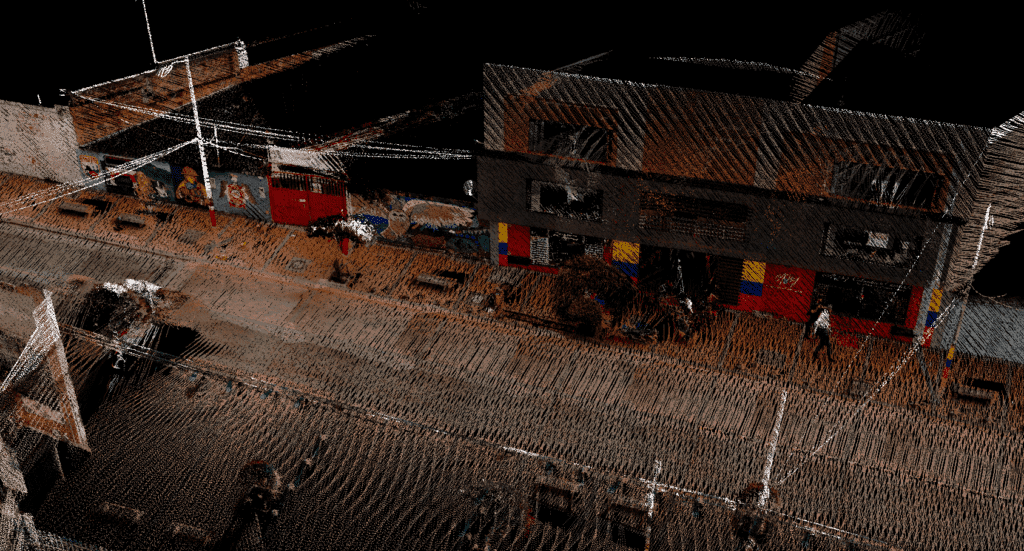
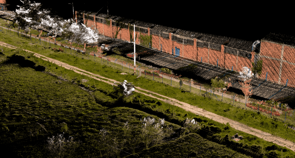
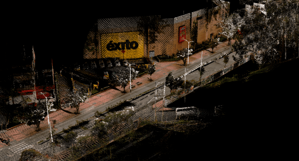
First, it was necessary to collect enough point cloud data using a vehicle-mounted LiDAR for a 3D representation of the grid network. However, to accurately evaluate the condition of the grid, a more detailed visual representation of the network is necessary. This is when it came to address the need to colorize the point cloud.
“What the client needed was a real picture of the network, whether it is in good or bad condition. So, we needed a high-definition photograph of every asset, of every single pole, of all the wires.”
Digital twins in the utilities
The importance of putting color to the point cloud in the utilities is enormous.
“We had to make sure the team involved in the asset inspection can zoom in and detect if there is damage, for example on the transformer or on the connectors with the wiring or on any part of the poles, like corrosion for example.
You need to have digital twins of all the network components at hand to know which parts need to be replaced. You also need to know the exact condition of the electrical grid to be able to plan the maintenance efficiently and strategically.”
Looking for the right 360° camera for electrical grid analysis
Choosing the right 360° camera for your mobile mapping project is a complex process with many considerations. Apart from the price, all the specifics of the mobile mapping project need to be taken into account. The 360° camera needs to meet the project’s requirements for data accuracy, collection speed, and post-processing, among other factors.
“When you are about to invest in a valuable camera, you need to make sure you make the right decision. This can be difficult as you usually don’t have the option to try the camera.”
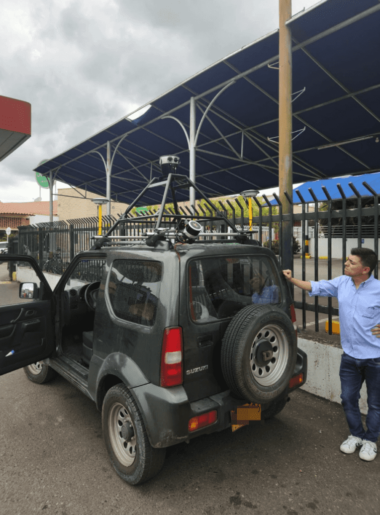
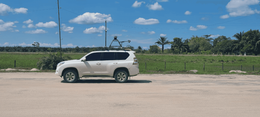
What Dymaxion was looking for in the electrical grid analysis project was a 360° camera that could integrate with LiDAR. For grid analysis, photogrammetry alone can be challenging due to natural obstacles to light, such as trees.
Another key element in the decision-making process was the camera’s high-definition pictures. They provided a detailed grid network analysis, so the client could understand the condition of all network components. The Mosaic 51 camera system, with its six 12K resolution sensors, was the ideal candidate.
“Of course, we found a wide range of different versions of 360° cameras online. However, a detailed comparison of Mosaic 51 with another solution we found on their website gave us a clear idea about the details that can be captured by Mosaic 51, and that brought a lot of our attention to this 360° camera.”
Integrating Mosaic 51 with LiDAR
After receiving the camera and performing initial testing, it came to integrating Mosaic 51 with LiDAR.
“There was a lot of development ahead as Mosaic 51 is not a LiDAR integrated solution.” (The solution fully integrated with RIEGL LiDAR is Mosaic X, but that system was not available back then.) “However, the time we spent with the integration helped us a lot in the way we understood how this merge was going to work.“
With the amount of captured data, Dymaxion needed an easy and automated solution to pair images with the point cloud. All data captured by Mosaic devices is non-vendor-locked, allowing Dymaxion to select software that enables additional calibration in post-processing.
“There was a lot of work to be done but the outcome is really great. We have a very good visualization for our client.”
While rolling shutter sensors require additional effort to colorize point clouds (compared to global shutters), Dymaxion proved it is possible!
The benefits of non-vendor-locked data captured by Mosaic
Apart from the greater flexibility in how the data can be analyzed and visualized, it also enhances the cost efficiency. This allowed Dymaxion to address the post-processing calibration issues because the data is not vendor-locked.
“One of our previous cameras with a built-in software entails relatively high software update and license renewal costs, especially because of the different currencies. So, it is great that with Mosaic, we can make our own solution for post-processing without having to renew a software contract year after year. “
Challenge #2: Mosaic 51 on the road again – The highest possible accuracy road inspection
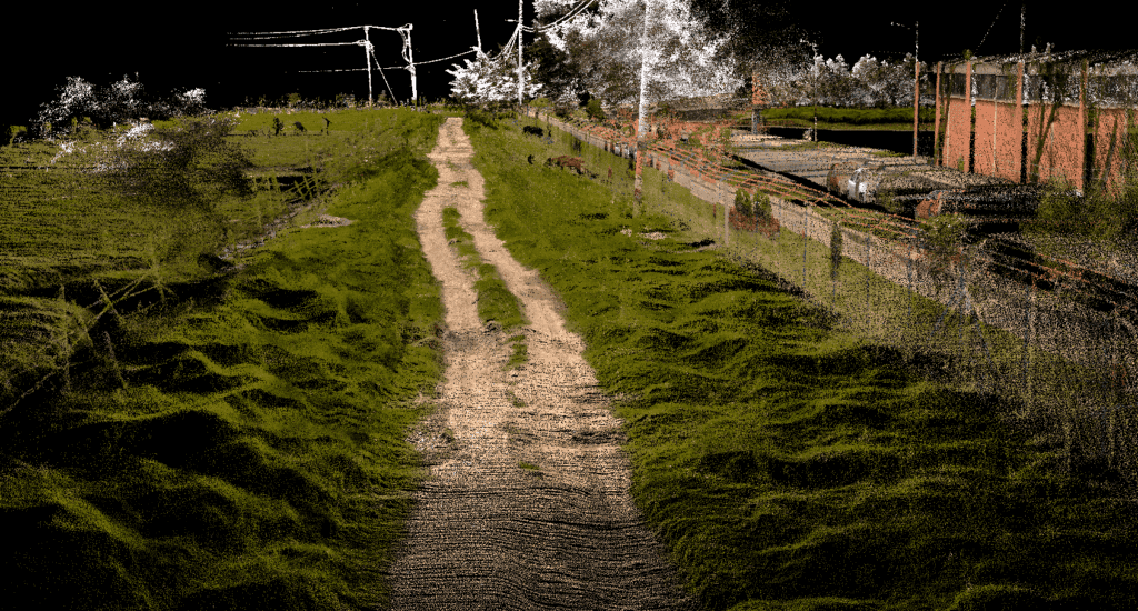
Shortly after the grid analysis project, Dymaxion decided to use it for road inspection. Several important road projects are currently underway in Colombia, including a major expansion of a motorway.
Long stretches of motorways in Colombia only have two lanes because the construction project was terminated after the first stage. Their widening is now being taken care of by a new contractor. But to pick up where someone else left off, the new contractor needs to know the exact condition of the construction. This includes the inventory and condition of all assets, such as road surfaces, railings along transport routes, road signs, and information about the surrounding terrain.
Road inspection in extreme weather conditions
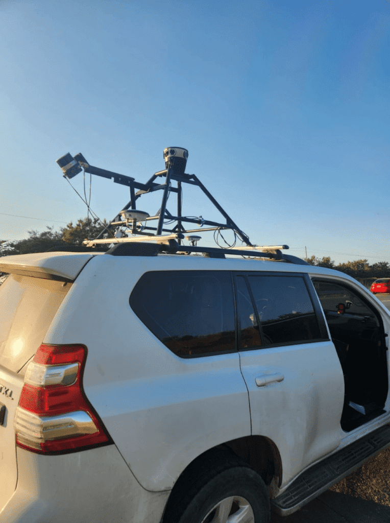
The mobile surveying project was conducted in northern Colombia, where the temperature during the day can easily exceed 35°C, and the scope of the mobile surveying required continuous data capture throughout the day.
“The temperature on the car rooftop in the daytime can easily go over 40 degrees. We were a little worried about the functioning of the camera in these extreme weather conditions, but we’d drive 300-400 km/a day in this very hot weather and the camera was working perfectly. “
This is a good illustration of the Mosaic‘s 51 robust industrial frame and benefits for mobile surveying in difficult weather conditions.
(updated March 2024)
The trees that keep the temperature lower are, unfortunately, an obstacle to the data capture using only a UAV LiDAR. Dymaxion combined aerial LiDAR data with vehicle-based LiDAR and Mosaic 51 360° imaging to ensure the clearest possible geo-referenced picture. For smaller inventory mapping projects, utilizing the 12.3K resolution of the Mosaic 51 360° camera is sufficient. However, in this case, precisely geo-referenced LiDAR data is required as a background for further construction.
The importance of a good timestamp
When acquiring geospatial data simultaneously with multiple sensors, precise timestamps ensure that these measurements accurately synchronize with one another. In this case, the Mosaic 51 360° camera, the built-in GNSS receiver, and an IMU captured the motion data.
“This part was a little bit complicated, to align the timestamps from the IMU and the GNSS with the nanosecond the image was taken. We didn’t have an exact match but using six control points over the road in the post–processing actually did the job.”
Being aware that the data post–processing can be demanding, Mosaic has been developing and fine-tuning an automated solution for geo-referencing (stitching) the images using a calibration template, which our clients can soon be looking forward to. (Stay tuned!).
Maximum efficiency with a dynamic approach
As the name of the company suggests, Dymaxion is another one of our customers who is not afraid to grow with big projects and is ready to find a solution for any challenge along the way. At the same time, they can rely on the best-in-class mobile mapping solution, Mosaic 51 360° camera that can withstand harsh climatic conditions and can operate all day without the speed of data capture, the accuracy of data output, or the high-resolution of the image important for grid analysis being affected.
Today, Mosaic already has a mobile surveying solution for advanced photogrammetry, fully integrated with Riegl laser scanners, Mosaic X. At the time when Dymaxion was looking for a 360° mobile mapping solution, this was not yet the case. However, thanks to a diligent integration and post-processing effort, they were able to integrate high-definition data captured by Mosaic 51 into the point cloud, allowing Dymaxion to not only provide image-like and geo-referenced data to the client but, most importantly, to build trust, which we believe to be the key to successful projects.


