
Surveying is the bedrock of urban planning. Mosaic is making that job easier for the largest cities in Nigeria.
Nigeria’s smart cities
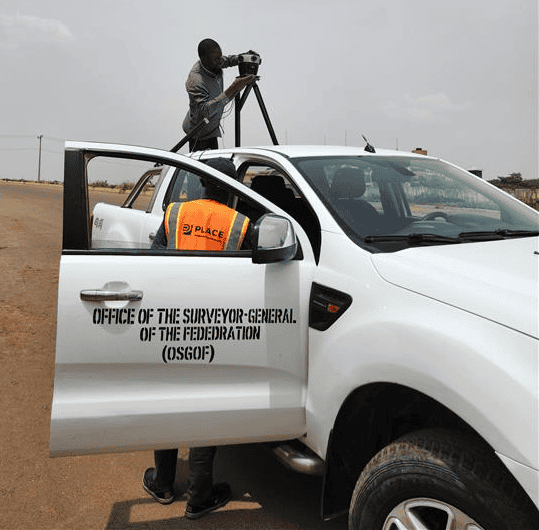
In an era where digital twins, GIS, smart cities, and mobile mapping are driving more direct and responsive urban development, the Office of the Surveyor General of the Federation (OSGOF), in cooperation with PLACE, is moving forward with bold plans to modernize infrastructure data collection in Nigeria.
At the heart of their latest initiatives is the Mosaic 51 mobile mapping system. It is opening new possibilities for 360° imagery in Nigerian cities. At the core of this plan is strategically planning smart cities that are better equipped to handle population growth, climate change, and the demand for safer road conditions.
In a detailed conversation with Ibrahim Samir, the Assistant Chief Surveyor at OSGOF, we explored the background, decision-making, use cases, and future vision behind OSGOF’s adoption of the Mosaic 51.
OSGOF’s role
OSGOF is the federal authority responsible for surveying and mapping across Nigeria. The office’s services span trigonometry, aerial mapping, drone operations, ground surveys, and advanced geodetic referencing. These services align Nigeria with international frameworks like the African Geodetic Reference Frame (AFREF).
Ibrahim Samir, a trained surveyor with over 15 years of experience, plays a key role in the unit responsible for deploying advanced tools like GNSS base stations, drones, GPR systems, and now the Mosaic 51 camera system.
OSGOF’s broad range of tools and talents makes it a crucial actor in infrastructure development, land administration, boundary demarcation, national security, and urban planning.
However, there are many challenges to performing these critical services in Nigeria.
Challenges in Nigeria with surveying and infrastructure planning
Before turning to Mosaic, Nigerian surveyors often had to rely on old-school or incomplete methods of data collection. These approaches proved insufficient for detailed street-level visualization and city modeling. For example:
- Relying solely on aerial imagery, which cannot read street signs, show the conditions of telephone poles, or give users the full experience of being on the street.
- Referring back to older datasets that are missing critical information. Many cities in Nigeria have not been mapped at large scales since the 1970s. Features such as updated building facades, road assets, and property conditions are missing.
- Persistent misconceptions around GIS, its capabilities, and its limitations.
On Google Maps’ Street View, for example, only 20% of African countries have even partial coverage, and that coverage is limited to only the largest cities or most popular tourism destinations.
“In Africa, when you say GIS, everybody believes it is just Google Maps. People don’t understand the need for real data that can be manipulated and analyzed for decision-making. Data ownership is another key aspect that can’t be ignored.”
Ibrahim Samir, Assistant Chief Surveyor
Selecting the Mosaic 51 for Nigeria’s unique surveying needs
Samir discovered Mosaic through GIM International’s newsletter and began comparing mobile mapping options. The timing coincided with a proposal to create a smart city model within Nigeria.
Understanding that aerial views alone weren’t enough, OSGOF needed a street-level solution to capture detailed ground-level imagery. This need led directly to acquiring the Mosaic 51.

The Mosaic 51 stood out from the competition for several reasons:
- Affordability: The Mosaic 51 360° camera was priced within reach for OSGOF. No hidden subscription or licensing fees to access the data meant they could keep using the software programs and data-storage options they already had access to.
- Camera specifications: With 12.3K resolution and having been tested to IP67, the Mosaic 51 had the right combination of detail and durability. The camera needed to be able to handle the climate and road conditions, but also had to capture small details of road assets and street furniture. Street signs, house numbers, and the conditions of electrical assets were clearly visible in the Mosaic 51’s imagery.
- Technical potential: non-proprietary data that could plug-and-play into a wide range of software programs and departments was essential to getting the most out of OSGOF’s data-capture trips.
Frank Pichel from PLACE, the supporting organization, also vouched for Mosaic’s quality in Nigeria’s harsh climate.
“With the Mosaic camera, the PLACE team is able to efficiently capture the high-resolution imagery and positionally accurate data our members require. We’ve worked with a range of cameras over the years, but the ability to collect quality data at any speed, regardless of weather and changing light conditions, and in a solid hardware package that can handle occasional branches, sets the Mosaic camera apart. Combine the equipment with first-rate support from the Mosaic team, and I don’t see us using a different camera for primary data collection.”
Frank Pichel, Managing Director at PLACE
Overall, for a government agency working under public procurement rules, the Mosaic 51 offered the best price-to-performance ratio.
One step closer to digital twins
The Mosaic 51 mobile mapping camera is a key piece of OSGOF’s goal of creating digital twins of Nigerian cities. These 360° panoramic captures supplement aerial surveys to model building heights, conditions, road structures, and utilities.
Before purchasing the Mosaic 51 camera, street-level data collection was fragmented or entirely absent in OSGOF’s operations. However, now they can deploy a mobile, fast, and high-resolution mobile mapping system wherever they need to collect data.
The data also supports inter-agency work: statistical offices, business licensing units, property tax authorities, and urban inspectors all benefit from the rich visual layer that the Mosaic 51 provides.
“The Mosaic 51 has really changed how we capture data. Before, there was no street-level imagery, but now we can build models that reflect the actual conditions on the ground.”
Samir Ibrahim

One dataset, many uses
After OSGOF’s first data capture session, colleagues and other departments took notice. They expressed interest in how they could tap into the imagery for infrastructure assessment, street signage inventory, and visual land audits.
“Everyone was amazed. We finally got something visual that reflects the streets. They kept asking, ‘What is that system? It looks great!’” said Samir.
Although the deployment is still in its early phases, OSGOF’s work is receiving positive internal feedback. The surveyors are impressed by the clarity and realism of the 12.3K resolution imagery. It supports more accurate land-use planning and auditing.
This enthusiasm suggests that a broader rollout, backed by stakeholder awareness and inter-agency collaboration, could accelerate smart city efforts and national urban modernization plans.
Non-proprietary data is at the heart of smart cities
Thanks to Mosaic’s non-vendor-locked data format, the same dataset can move from department to department. The data is reusable for a variety of purposes without worrying about retraining teams on new, proprietary software.
Non-vendor-locked data is also more cost-effective. Forget about monthly subscriptions and licensing fees when you own your data!
Smart city technology is most efficient when multiple departments can access and analyze the same dataset. Street-view imagery in urban settings has a wide variety of use cases, including:
- Electrical grid asset management, which involves surveyors capturing and cataloging poles, transformers, junction boxes, cables, and other utility hardware along every street. Up-to-date 360° photos let infrastructure teams remotely inspect. Find wear, identify missing or damaged components, and plan maintenance or replacement schedules more efficiently.
- Road maintenance crews can flag potholes, cracking, faded lane markings, drainage issues, and encroaching vegetation. Regular surveying means smart cities can compare imagery over time to prioritize project budgets. Decide the best time to repair or resurface roads, and validate contractor work, without sending crews out for every single project.
- Cadastral verification & property tax assessment allow tax offices to cross-reference street-level imagery with land registry maps. This process confirms building footprints, detects unauthorized structures or extensions, and verifies land-use classifications. Using “ground truth” technology streamlines tax roll updates, reduces disputes, and supports fair, data-driven revenue collection.
- Street furniture & signage inventory is easier than ever with software that automatically detects and maps benches, bus shelters, bike racks, streetlights, traffic signs, and planters. A visual inventory helps municipalities manage assets’ lifecycles, schedule replacements, and ensure safety compliance.
- Emergency response planning is incredibly important for modern cities. Integrate street-view panoramas into your GIS for a digital footprint of emergency access routes, fire hydrant locations, fire-lane widths, and potential obstructions to emergency personnel.
The Mosaic 51’s role in future Nigerian projects
Looking ahead, Samir sees the Mosaic 51 mobile mapping system as a core component of Nigeria’s digital mapping transformation. The overarching goal of OSGOF is to extend high-resolution city models to urban centers beyond Abuja and Lagos. OSGOF is also interested in expanding collaborations with other agencies to streamline data sharing and analysis.
By combining traditional surveying expertise with modern imaging technology, Nigeria is charting a smarter path toward national development, infrastructure management, and digital governance. As cities grow and development accelerates in Nigeria, the demand for real-time, high-precision, and georeferenced imagery will only increase.
The Mosaic 51 offers a practical and economical path toward meeting those demands in developing economies with its
- Rugged IP67-tested camera that can handle Nigeria’s heat and humidity. It is ready to travel over the bumpiest of roads in both urban and rural settings.
- Distance-based triggering which reduces duplicate or useless data in stop-and-go traffic, at stoplights, and while waiting for pedestrians to cross the road.
- Non-vendor-locked data that is meant to be used, reused, and shared among various departments and their many software programs.
Ready for your smart city?
Mosaic’s partnership with OSGOF validates its mobile mapping systems’ global appeal. From American rail corridors to European VFX projects to Nigerian smart cities, Mosaic continues to prove that powerful mapping technology doesn’t have to be out of reach.
If you’re ready to take your smart city to the next level with street-view imagery that you own, contact our team today.
November 2025 update: Check out this case study between OSGOF and ArcGIS on leveraging ArcGIS reality and GeoAI for mapping settlements in Abuja, Nigeria.


