
This LinkedIn article was previously published on May 1, 2025, by Cameron Rex MAI, R/W-AC, GISP of RMI Valuation.
Imagine being able to review and appraise a 65-mile railway corridor—from your desk—long after the fieldwork is complete. The field team has already done the heavy lifting; now the entire corridor is available to explore virtually, with panoramic precision.
Over the past decade, that’s exactly what RMI Valuation has been working toward—transforming the way railroad corridors are documented, valued, and managed using 360° imagery. What began as an ambitious experiment in panoramic capture has grown into a fully integrated, end-to-end workflow: from field deployment to spatially intelligent, map-driven analysis.
In this article, we share the evolution of our 360° approach, highlight recent breakthroughs like the Mosaic 51 camera and Esri’s Oriented Imagery, and show how these tools are driving better outcomes for railroads, appraisers, public agencies, and beyond. We’ll also look ahead at what’s next.
Short on time? Here’s the TL;DR:
TL;DR
RMI Valuation has developed an end-to-end 360° imagery workflow for rail corridors—combining the Mosaic 51 camera, RTK GNSS, and a custom ArcGIS Python toolbox. Imagery is automatically processed into Esri Oriented Imagery Datasets for GIS-based analysis and remote inspection. The result: fewer field visits, faster decisions, and reusable data assets for valuation, planning, and corridor management—with future enhancements including AI-driven analysis and broader asset integration.
A DECADE OF EVOLUTION IN 360° CORRIDOR IMAGERY
Photography has long been part of RMI Valuation’s workflow, but our approach began to evolve in 2014 when we started using action cameras to document corridors in motion—laying the groundwork for more dynamic and immersive workflows. At that time, we also relied on traditional cameras and smartphones, often requiring manual geotagging or post-processing to align imagery with location data. Then in 2016, we took a significant step forward by integrating 360° cameras into our workflow—well before “digital twins” became an industry buzzword. This early experimentation with immersive imaging set the stage for the scalable, map-centric systems we deploy today.
, demonstrating RMI’s initial experimentation with immersive imagery.")
These early, non-360° approaches made one thing clear: visual context was critical. Conventional imagery—captured with smartphones, action cameras, or DSLRs—allowed us to inventory assets, identify encroachments, and revisit corridor conditions virtually. But there was also a limitation: the imagery reflected only what the field crew chose to capture in the moment. The perspective was fixed—framed by the person behind the camera and limited to what they anticipated would be relevant later.
This is what led us to embrace 360° capture. Unlike conventional photography, 360° imagery shifts control from the image-taker to the image-viewer. With spherical panoramas, stakeholders aren’t limited to a single angle—they can look wherever they need: behind, beside, or above the original point of focus. This evolution didn’t just enhance our documentation – it fundamentally changed how our team, and our clients, could interact with the corridor. Think Google Street View on the railroad.
As technology advanced, so did our workflow. We moved through several generations of consumer 360° cameras—starting with a Kickstarter-backed Giroptic 360cam, followed by the Insta360 One X, One X2, and eventually the One RS 1-Inch 360. Each brought incremental improvements in resolution, stitching, and capture flexibility. By 2019, we were generating fully spherical, georeferenced imagery and experimenting with ways to incorporate it into our enterprise GIS workflows—though robust integration remained out of reach. Still, this imagery enabled us to review every curve, bridge, signal, or encroachment in panoramic detail from the desktop, laying the foundation for more immersive corridor analysis.
However, challenges remained. Many consumer devices saved imagery in proprietary formats, requiring time-consuming conversions. Geospatial metadata was often incomplete or inconsistent, leading to additional post-process geotagging. Most cameras relied on time-based capture intervals, which required careful tuning based on anticipated travel speed—and still frequently led to excessive image volumes.
Even when we successfully brought these images into our GIS, the experience was limited. While we could click on individual image points, we couldn’t select a location or asset on the map and retrieve the corresponding perspective from an image that covered it. That disconnect—between map interaction and immersive viewing—made large-scale analysis slow and cumbersome.
At the time, Esri’s Oriented Imagery tools were still in early development and not yet fully integrated into ArcGIS Pro or Online. Using them required workarounds and manual configuration, making the process impractical for operational use. It wasn’t until recent updates that Oriented Imagery became a viable, scalable solution for connecting imagery with spatial workflows.
Despite the technical hurdles, the benefits of 360° capture were already clear. What once required multiple site visits and static photos became a one-pass field operation that produced a reusable visual archive. We saw measurable time savings, improved safety (fewer hours on live tracks), and a foundation for the GIS-driven valuation workflow we deliver today.
Crucially, we made 360° imagery a standard practice in our corridor appraisals—not just a novelty. Whether documenting a rural rail line or an urban right-of-way, our team used panoramic imagery to refine asset inventories and conduct virtual inspections from the desktop. This consistency laid the groundwork for the major leaps we’ve taken more recently—deploying cutting-edge hardware, automating our workflows, and bringing immersive spatial data into the center of the valuation process.
NEXT-GEN 360° CAPTURE: DEPLOYING THE MOSAIC 51 CAMERA AND ORIENTED IMAGERY
In 2025, we marked a turning point in our 360° imagery capabilities. With the deployment of the Mosaic 51 camera, RMI has moved from adapting consumer-grade tools to leveraging a professional solution purpose-built for mobile mapping. This rugged, all-in-one camera delivers 12.3K ultra HD resolution through six synchronized lenses and onboard GNSS—all housed in a compact, field-ready package.
To enhance positioning accuracy, we pair the Mosaic 51 with an external Emlid Reach RS3 unit—an RTK-enabled GNSS receiver that provides real-time correction data during capture. This allows us to geotag imagery with survey-grade accuracy, improving both downstream processing and GIS integration. While the Mosaic 51 embeds basic geospatial metadata, our use of RTK correction significantly boosts precision for corridor workflows.

More importantly, the Mosaic 51 allows us to overcome many of the limitations in our earlier workflows:
- Distance-based capture replaces time-based intervals, enabling us to trigger image collection every 5, 10, or 20 meters—eliminating guesswork and excessive image counts.
- Embedded geospatial metadata means each image is already tagged with precise coordinates, orientation, and timestamp—dramatically reducing post-processing.
- Open, professional-grade formats streamline integration with stitching tools (like MistikaVR) and GIS platforms without the need for proprietary conversions.
Operationally, the Mosaic 51 is built for the environments we work in—dustproof, waterproof, and ruggedized for rail corridors, yards, dirt access roads, and hi-rail vehicle mounts. With onboard storage and no need for a tethered PC, a single operator can capture high-resolution panoramic imagery all day while still performing other inspection tasks. No more capturing thousands of redundant images while stationary at one location.
In short, it’s a leap forward in reliability, efficiency, and image quality—giving us a smarter, faster, and more scalable way to capture the corridor.
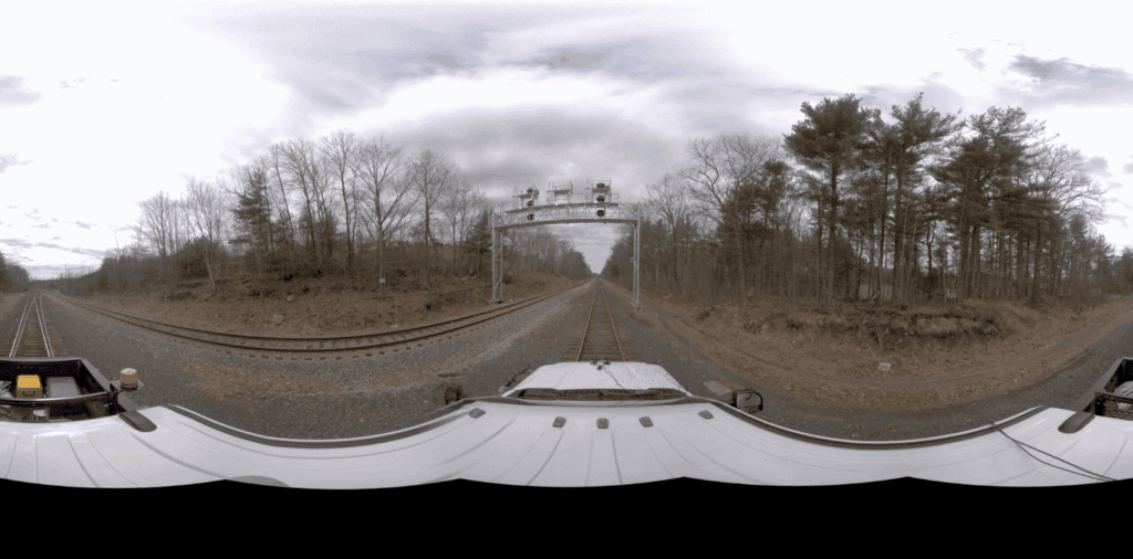
What does this mean for our clients? First, the image quality. The Mosaic 51 captures exceptional detail—features like milepost markers, switch stands, and fiber optic markers are clearly visible, even at speed. Second, operational simplicity. Once configured, the camera captures imagery automatically at defined distance intervals and runs consistently with minimal oversight—freeing the operator to focus on inspection or navigation.
Equally important is the ability to reuse imagery across teams and use cases. A single corridor pass can produce a spatially accurate, high-resolution dataset that supports valuation, planning, engineering, and stakeholder review—without the need for repeat visits. This “capture once, utilize tenfold” approach reflects our broader commitment to building reusable spatial data assets that continue to deliver value long after the fieldwork is done.
The Mosaic 51 solves many challenges in the field—but hardware is only half the story. Capturing great imagery is just the beginning; the real value emerges when that data is organized, mapped, and made actionable in GIS. To truly capitalize on the new imagery, we embraced Esri’s Oriented Imagery technology for integration and viewing. Oriented Imagery is an ArcGIS capability that allows users to manage, view and interact with spatially referenced images—whether ground-based or aerial—directly within the map environment, based on camera location, orientation, and footprint.
In our case, we use it to create interactive 360° photo layers along the corridor map. When a project’s images are loaded as an Oriented Imagery Dataset (OID) in ArcGIS, our team (and the client) can click on any location in the corridor map and instantly open the corresponding panoramic photo at that spot. As you pan or zoom the image, a footprint on the map shows the camera’s field of view, and you can even see multiple images from different angles. We’ve effectively created a corridor-specific “Track View” experience—offering the intuitive navigation of Street View, combined with the spatial accuracy and attribution needed for professional analysis.
The combination of Mosaic 51 imagery and ArcGIS Oriented Imagery delivers an immersive, map-centric experience. It enhances spatial analysis and situational awareness by allowing users to explore corridor conditions in high-resolution detail, directly within the GIS environment. A valuation team member can virtually stand on the tracks and look 360° around, confirming asset conditions during appraisal, while a railroad engineer could examine a particular signal or grade crossing remotely. By enhancing the Oriented Imagery Viewer in ArcGIS with our high-res photos, we bring the corridor to life on screen. This translates into better-informed decisions and collaboration – everyone sees the same ground truth, without the logistical hurdles of organizing a field visit for every question.

AUTOMATING THE WORKFLOW WITH AN ARCGIS PYTHON TOOLBOX
Deploying new cameras and viewers is exciting, but RMI didn’t stop there. We recognized early on that handling thousands of images per project could quickly become a bottleneck if done manually. To ensure speed, consistency, and scalability, our team developed a custom ArcGIS Python toolbox to automate the entire 360° imagery processing workflow.
Here’s how it works in practice: as soon as our field team returns with a full day’s—or multiple days’—imagery from the Mosaic 51, the toolbox takes over—automatically performing a series of geoprocessing steps:
- Rendering and Geotagging: Using Mosaic’s CLI tools in combination with MistikaVR, the toolbox initiates rendering of raw imagery reels and synchronizes them with GPX tracklogs—automatically producing stitched, georeferenced 360° images ready for spatial use.
- Building and Populating Oriented Imagery Datasets: It creates the full OID structure within ArcGIS Pro, loading each image with orientation metadata, footprint geometry, and attribution fields—no manual schema creation or field population required.
- GPS Correction and Metadata Tagging: The toolbox smooths GPS noise, interpolates where needed, and embeds corrected location and orientation data directly into the EXIF/XMP tags. It also applies standardized filenames and metadata for consistency across datasets.
- Route-Based Attribution and Contextual Labeling: Images are automatically enriched with corridor-relevant fields—such as mileposts, railroad subdivisions, and reverse-geocoded location names—adding valuable context that supports filtering, search, and reporting in the GIS.
- Cloud Publishing: Final imagery is uploaded to Amazon S3 for secure hosting and archival, while the Oriented Imagery Dataset is published to ArcGIS Online or Enterprise Portal for seamless integration into web maps and applications.
- Unified Workflow Execution: For complete automation, a master tool runs all steps in sequence—transforming raw Mosaic reels into a fully structured, ready-to-publish OID with no manual intervention beyond configuration.
By automating these steps, RMI has significantly reduced the turnaround time from field capture to a usable imagery layer. What once took multiple days of manual work now happens in minutes. More importantly, automation eliminates human error in the data prep stage—no missing photos, no typos in coordinates, no inconsistent naming. The output is reliable, reproducible, and enables us to hit the ground running (virtually) as soon as the data is collected.
From a client’s perspective, this automation means faster delivery of results. For instance, a railroad client could have a GIS web application ready to explore imagery captured just the day before. That kind of rapid turnaround is critical when imagery supports time-sensitive decisions, whether reviewing corridor conditions ahead of a negotiation or responding to a reported issue on the track.
On average, the toolbox processes each 360° image in about six seconds—including rendering, tagging, dataset generation, and cloud upload. Looking ahead, we aim to cut that time significantly by shifting processing to the cloud, as roughly 75% of current processing time is consumed by upload and transfer steps.
The Python toolbox effectively bridges the gap between capture and consumption, connecting the entire workflow—from camera to intelligence.
PUTTING 360° IMAGERY TO WORK: KEY BENEFITS FOR STAKEHOLDERS
We’ve built a streamlined pipeline from camera to intelligence—but what does that mean in practice? For our clients and partners, it means faster access to critical information, fewer field visits, and smarter decisions. Here’s how different stakeholders could realize value from our 360° workflow—whether in current projects or future deployments.

Benefits for Railroads & Corridor Operators
Railroads remain at the center of our work—both as the corridor owners and as the primary stakeholders in valuation, maintenance, and planning decisions. For these teams, 360° imagery offers clear operational advantages, especially when it comes to documenting assets, reviewing conditions, and sharing information across departments and partners:
- Comprehensive Asset Inventory: High-resolution 360° images provide a visual record of every asset along the right-of-way—tracks, signals, bridges, mileposts, utility crossings, and more. This georeferenced “virtual corridor” ensures nothing is overlooked in valuations or asset management. Maintenance teams can verify equipment locations and conditions without a special site visit, complementing their asset databases.
- Remote Insight for Broader Teams: While on-site inspections remain critical for maintaining safe and reliable railroad infrastructure, 360° imagery offers powerful support beyond the field. With high-resolution, spatially accurate panoramas available in the GIS, railroad staff who aren’t in the field—managers, analysts, planners, or legal teams—can now “walk the corridor” virtually. This brings the field into the workplace, enabling faster, more informed decision-making across departments.
- Improved Context for Incident Review and Planning: Instead of relying solely on field reports or static photos, teams can review conditions in detail from the office—identifying areas of concern like encroachments, vegetation growth, or property issues, planning project scopes, or validating asset inventories. In emergency scenarios, recent imagery helps assess reported issues and prioritize response with greater clarity.
- Support for Stakeholder Communication and Negotiation: 360° imagery can help railroads communicate conditions clearly to external parties—whether in easement negotiations, capital planning, or corridor transfers. Visual records can reduce uncertainty, speed agreement, and focus conversations on actual constraints and opportunities.
Benefits for Appraisers & Valuation Professionals
For RMI, 360° imagery isn’t just a technological upgrade, it’s a valuation tool. While most of our imagery is used in corridor-specific contexts, its core advantage—being able to revisit and evaluate conditions from any angle—supports the same standards of accuracy, transparency, and defensibility that matter in all forms of appraisal. Here’s how it enhances our own process and strengthens the foundation of modern valuation workflows:
- Greater Accuracy and Confidence: 360° imagery allows appraisers to virtually re-walk the corridor as many times as needed, ensuring no asset or encroachment is overlooked. We can zoom in on structures, verify proximity, and cross-check field notes with spatial imagery. This reduces ambiguity and supports more defensible conclusions – especially when reports are subject to review or litigation. Many key observations can be visually verified, providing a clear audit trail for decision-makers.
- Efficiency and Reduced Site Time: By leveraging high-quality street-level imagery, our team can conduct “desktop inspections” for many aspects of the assignment. Routine checks that once required another trip (or an extra person in the field) can be done in the office, as long as the imagery is current. This can reduce the need for repeat or supplementary field inspections in many cases, especially when imagery is recent and conditions are stable, while still complying with industry standards for remote appraisal work. In turn, this means quicker turnaround for clients and lower expenses, without sacrificing thoroughness.
- Stronger Communication and Reporting: While appraisal reports remain static by nature, 360° imagery gives us flexibility in what we choose to present. We can include snapshots from any direction—based on what’s relevant at the time of reporting—not just what was captured in the field. Embedding these visuals alongside maps or exhibits helps non-specialist readers (e.g., legal teams, property owners, stakeholders) understand the context behind our conclusions. In some cases, we’ve also provided interactive web maps to allow stakeholders to explore the imagery themselves—enhancing transparency and engagement beyond the written report.
Benefits for Public Agencies & Other Stakeholders
Beyond railroad operators, 360° imagery also provides meaningful value to public agencies, trail groups, conservancies, and other corridor stakeholders. Whether planning a rail-trail conversion, conducting environmental review, or managing long-term stewardship, these organizations benefit from imagery that brings real-world conditions directly into the planning process.
- Transparency and Shared Understanding: Stakeholders involved in corridor projects—whether public agencies, trail organizations, or advocacy groups—can gain a clear, ground-level view of current conditions through 360° imagery. For example, when a rail corridor is being considered for trail conversion or transit reuse, decision-makers can virtually tour the route to identify challenges such as encroachments, crossings, or environmental constraints. This shared visual reference supports more productive discussions, faster alignment, and smoother community engagement.
- Enhanced Corridor Management and Planning: For those responsible for maintaining or improving corridors, up-to-date 360° imagery serves as a practical tool for monitoring safety issues, planning upgrades, and tracking compliance. It also helps environmental and preservation groups assess habitats, structures, or cultural features without needing a physical site visit—especially useful in remote or hard-to-access areas.
- A Historical Archive for Long-Term Stewardship: Capturing imagery at regular intervals creates a time-stamped visual record of the corridor’s evolution. Over time, this archive becomes an invaluable asset—helping corridor partners analyze changes in land use, infrastructure, or vegetation. It supports future appraisals, trail development plans, engineering studies, and public communications—whether to document progress, flag changes, or demonstrate impact to funders and stakeholders.
In all cases, the overarching benefit is better information leading to better decisions. Whether it’s a Class I railroad evaluating a potential sale, an appraisal firm striving for greater accuracy, a public agency planning a rail-trail conversion, or a land conservancy managing long-term stewardship, RMI’s 360° imagery—when combined with traditional methods—adds a new dimension of spatial insight and workflow efficiency. Integrating track-level 360° imagery directly into GIS environments has proven transformative: it enhances situational awareness, accelerates planning, and enables teams to explore the corridor as it truly exists—not just as lines on a map. That’s the value we see unfolding across our corridor projects, and the opportunity we believe it holds for our partners moving forward.
FUTURE OUTLOOK: PUSHING CORRIDOR INTELLIGENCE FORWARD
RMI Valuation is proud of how far we’ve come with technology, but we’re focused on what’s next. Looking ahead, we see several exciting avenues to continue driving innovation in corridor valuation and mapping:
- AI-Powered Image Analysis: With thousands of high-res images per project, there is an opportunity to apply artificial intelligence to detect and catalog corridor features automatically. We envision using machine learning models to identify assets like signals, utility poles, bridges, or even to assess conditions (for example, flagging excessive vegetation near tracks or identifying areas of fouled ballast). The Mosaic 51 is designed with AI integration in mind, outputting imagery optimized for use with computer vision tools. In the near future, RMI aims to leverage AI to assist our experts—think of it as having a digital assistant scan every image and highlight points of interest, thereby speeding up the appraisal and analysis process even further.
- Expanded Coverage & Frequency: While our primary focus has been railroad corridors, the same 360° imagery workflow is equally applicable to pipeline corridors, power line rights-of-way, and highways. We plan to extend our services into these areas—helping utilities, DOTs, and other infrastructure operators manage their linear assets with the same level of geospatial intelligence. We’re also exploring scheduled re-capture (annually or following major events) to keep corridor imagery current. Regular updates support change management, enable early issue detection (such as post-storm erosion) and build a continuous visual record for long-term asset condition monitoring.
- Enhancing Client Access and Integration: We anticipate that more of our clients will want direct, easy access to the imagery we collect. Beyond the ArcGIS-oriented imagery web apps we provide, we’re investigating lightweight web viewers and mobile applications that could allow a client’s field staff to pull up 360° corridor images on their tablet or phone while on-site. Moreover, we aim to integrate our imagery data with clients’ existing asset management systems—for instance, linking a railroad’s maintenance database to specific images of an asset. By breaking down data silos, we’ll ensure that our 360° imagery isn’t just a standalone product but part of a connected ecosystem supporting more connected, holistic corridor management.
Underpinning all these efforts is RMI’s commitment to staying at the forefront of geospatial innovation. We actively engage with the broader GIS and hardware communities—closely following developments from Esri and device manufacturers to assess emerging capabilities. For example, we’re tracking Esri’s roadmap for 360° video and augmented reality support in Oriented Imagery, which could open up new possibilities for corridor exploration. Our goal is to continuously enrich the toolkit we offer our clients. In the coming years, you can expect RMI to remain a forward-looking leader in this space—whether it’s through adopting the latest sensors, pioneering new analytical techniques, or setting best practices for the appraisal industry in the digital age.
CONTINUING THE JOURNEY: FROM CAPTURE TO INTELLIGENCE
RMI Valuation’s journey “from capture to corridor intelligence” illustrates how embracing innovation can fundamentally improve professional services. By integrating 360° imagery, advanced GIS, and automation, we’ve moved beyond traditional corridor appraisal—delivering a dynamic platform for valuation, planning, and spatial decision-making. The impacts are clear: more thorough valuations, streamlined negotiations, and a newfound ability for all stakeholders to virtually explore corridors with ease. And we’re not stopping here—as technologies like the Mosaic 51 camera, oriented imagery, and AI continue to evolve, so will our capabilities.
RMI Valuation has spent the past decade turning immersive corridor imagery into practical, spatial intelligence—and we’re continuing to push the boundaries. Whether it’s deploying advanced sensors, integrating with GIS, or exploring AI-assisted workflows, our goal remains the same: to make corridor data more accessible, actionable, and valuable for everyone involved.
We know we’re not the only ones rethinking how corridor intelligence is captured and used. If you’re exploring similar ideas—or wrestling with entirely different challenges—we’d love to connect, swap ideas, and learn from each other.
Learn More
ABOUT THE AUTHOR
Cameron Rex, MAI, R/W-AC, GISP is the owner of RMI Valuation, LLC, where he leads corridor-focused valuation projects and develops GIS-integrated workflows for real property analysis. With over two decades of experience specializing in rail corridors, Cameron combines deep appraisal expertise with technical leadership in geospatial systems and 360° imagery automation. He is a Designated Member of the Appraisal Institute, a Certified GIS Professional, and holds the Right of Way Appraisal Certification (R/W-AC). Cameron regularly speaks on technology and valuation in the railroad industry and currently serves as First Vice President of the American Railway Development Association.


