")
Mosaic and iTwin by Bentley – hardware and software combine for Digital Twin creation
Mosaic Camera Systems is excited to reveal its latest advancement in offering its customers an easier path to solving their 3D modeling needs. The company has recently joined Bentley Systems’ iTWIN developer program to enhance its future offerings.
Mosaic and iTwin
The coupling of the two technologies – one hardware and one software – generates impressive results for users in the Digital Twin sphere, specifically related to 3D modeling of large-scale infrastructure.
iTwin is Bentley’s “Open Platform for Infrastructure Digital Twins”. The platform provides the foundation for building SaaS solutions to design and build, as well as operate infrastructure assets. Users can accelerate their application development by allowing the iTwin platform to handle data integration, visualization, change tracking, security, and other complex challenges.
Mosaic designs and develops industrial-grade mobile mapping camera systems. Their cameras have already proven themselves to be the new industry standard in mobile mapping cameras. They are powerful tools for collecting high-resolution 360º street-level imagery. Additionally, these cameras are capable of creating highly realistic 3D models for use in Digital Twins. Recently, Mosaic utilized iTwin technology to produce 3D reality meshes from Mosaic X images.
You can see the first stunning results of the mesh created with iTwin technology from Bentley Systems here:
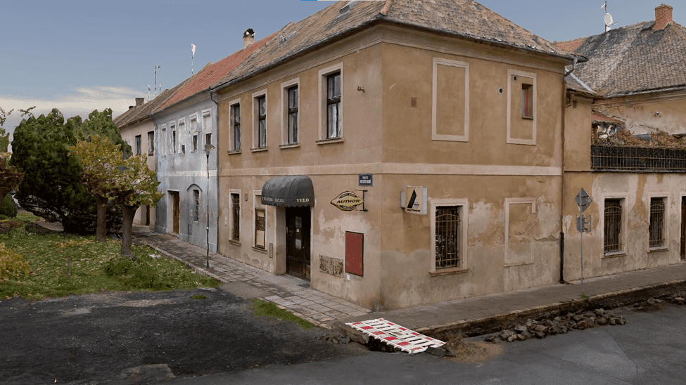
This dense mesh consists of drone photos alongside mobile mapping system photos. It features a total of 11,800 photos for 153GP and was created in just over 7 hours with the iTwin solution.
The dense mesh of only mobile mapping system photos without aerial imagery was 20GP less (133GP) and took only six and a half hours.
What this means for you
Mosaic’s forthcoming offering will allow users to efficiently create intricate, large-scale 3D reality meshes from Mosaic X images. The solution produces precise reality meshes cost-effectively. It also only requires minimal investment of time and resources.
In addition, one of the standout features of this offering will be the ability to merge aerial and street-level image data. Therefore, you can have a fully accurate and realistic model of entire cities or industrial sites, as demonstrated above.
To find out more about the possibilities, contact Mosaic’s sales team at:


