
Why road and pavement inspection companies are seeing the value of adding 360º street view to their arsenal
Discover the revolutionary transformation of pavement inspection with Mosaic camera systems, seamlessly integrating dual functionality and reshaping industry standards and uncover:
- The streamlined pavement inspection process achieved by Mosaic camera systems, efficiently integrating dual functionality.
- The optimization of field operations by Mosaic camera systems, delivering valuable data to inspectors and ensuring a safer and more efficient approach.
- Mosaic’s dual role in pavement inspection and comprehensive data collection, setting new industry benchmarks and contributing to a connected and efficient infrastructure management ecosystem.

Introduction
The landscape of pavement inspection is undergoing a revolutionary transformation as road and pavement inspection companies increasingly recognize the substantial benefits of integrating 360º street view technology into their operations. Traditionally, pavement inspection has been a meticulous process requiring high-end tools, but the adoption of advanced mobile mapping cameras is changing the game.
Recent study in the field of pavement asset management systems and technologies (PAMS) has significantly contributed to the evolution of pavement inspection processes. PAMS plays a significant role in assisting agencies and decision-makers in maintaining deteriorating pavement assets while optimizing budget allocation.
The advancements in pavement condition data collection and processing have revolutionized the estimation of remaining service life and the selection of optimal maintenance strategies. Image processing (IP) and artificial intelligence (AI) tools have played a crucial role in enhancing the overall performance of PAMS by effectively analyzing vast amounts of data derived from distress surveys.
Let’s take a look into the evolution of pavement management practices, highlighting the transformative capabilities of high-end mobile mapping cameras. These cameras not only facilitate pavement inspection but also enable comprehensive asset and infrastructure data collection concurrently.
The Dual Role of Pavement Inspection
Traditionally, pavement inspection involved using sophisticated tools to scrutinize road surfaces for tiny cracks and overall conditions. However, forward-thinking companies are now realizing that they can maximize efficiency by combining pavement inspection with the simultaneous collection of comprehensive asset and infrastructure data. This paradigm shift not only optimizes operations but also provides valuable additional data for various purposes.

Mosaic in Pavement Management
Pavement inspection companies are increasingly recognizing the value of incorporating camera systems into their operations. These systems not only streamline traditional pavement inspection processes but also offer a dual functionality that revolutionizes asset and infrastructure data collection.
Mosaic camera systems stand out as revolutionary mobile mapping solutions reshaping industries. These innovative systems, with their ability to capture highly detailed street view images in a fraction of the time compared to traditional methods, are pushing the boundaries of data collection in pavement management.
Mosaic camera systems offer a transformative approach to pavement inspection, providing a simple and reliable means of image collection at scale. Without the need for costly traffic management or road closures, a single operator can effortlessly gather street view data, offering a clear picture of roads and infrastructure.
This capability proves invaluable for right-of-way inspection, utility and telecom surveying, regular infrastructure mapping, asset management, and post-disaster response with accurate documentation.
Furthermore, Mosaic 51 and Mosaic X are two specialized solutions that enhance pavement management practices:
Mosaic X
Mosaic X, featuring a global shutter for photogrammetry ability at highway speeds, provides scalable photogrammetry and 3D modeling. Its capability to create dense point clouds and photorealistic environments facilitates easy point cloud colorizing when merged with other data. This functionality proves essential in accurately assessing pavement conditions and planning maintenance interventions.
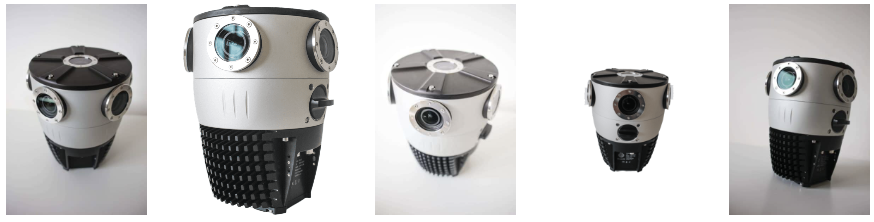
Mosaic 51
Mosaic 51, renowned for its durability, precision, and practicality in urban mapping and surveying, is specifically designed to withstand harsh conditions. This AI-compatible, rugged 12.3K-resolution 360º camera is ideal for HD surveying, GIS, and infrastructure inspection. With a robust industrial frame, connectors, and a built-in computer with large internal storage, Mosaic 51 allows for all-day capture without the need for a computer within the vehicle, reducing points of failure and simplifying the data capture process.. This makes it a valuable tool for continuous pavement monitoring and comprehensive data collection in challenging environments.
Together, Mosaic 51 and Mosaic X contribute significantly to optimizing pavement management practices by offering advanced imaging capabilities, durability, and operational efficiency.

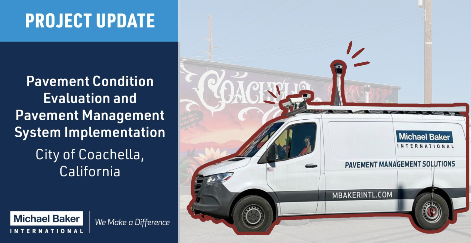
Real-world Implementation: MBI Success Story
Michael Baker International (MBI), an early adopter of this innovative approach, recently showcased their success on LinkedIn. Their pavement management system implementation in the City of Coachella, California, stood out. MBI’s Pavement Services team not only focused on pavement condition evaluation but also integrated a high-end mobile mapping camera into their pavement data collection vehicle.
“Michael Baker International’s Pavement Services team has been hard at work providing pavement condition evaluation and the implementation of a pavement management system for the City of Coachella, California. Key to this project is Michael Baker’s integrated pavement data collection vehicle, which provides high-quality 3D scans of the pavement surface as well as high-definition spherical imagery of the roadway right-of-way.
The pavement condition data will be used to implement a modern and practical pavement management software. Our team will configure the software and produce a pavement management report that will guide the city’s multi-year pavement maintenance and rehabilitation plan. Michael Baker will also work with technology partner AtlasView to deliver a live public-facing pavement condition map of the city that is accessible from its website and will provide up-to-date information to city residents regarding their pavement condition.”
Nathan, Associate Vice President at MBI, expressed satisfaction in working on the pavement management implementation and gave a shout out to AtlasView for their support. MBI’s project involved a high-quality 3D scanning pavement data collection vehicle, equipped with a high-definition spherical imagery camera. This vehicle not only scanned the pavement surface in 3D but also captured detailed imagery of the roadway right-of-way.
“It’s been very rewarding to work with the Engineers at the City of Coachella on this hashtag #pavement management implementation. Shoutout to AtlasView for their continued support.”
Nathan Kebede, P.E.
Associate Vice President at Michael Baker International

The collected data, beyond pavement conditions, will facilitate the implementation of a modern pavement management software. MBI’s team will configure the software and produce a pavement management report guiding the City of Coachella’s multi-year maintenance and rehabilitation plan.
Furthermore, MBI collaborated with technology partner AtlasView to deliver a live public-facing pavement condition map accessible from the city’s website, providing real-time information to residents about their pavement conditions.
Enhancing Field Preparedness for Inspectors
Beyond success stories like MBI’s, Mosaic camera systems provide practical benefits for inspectors in the field. Inspectors can now simultaneously perform pavement inspection and gather comprehensive data about infrastructure and assets above ground using 360º cameras.
For inspectors dealing with underground infrastructure challenges, access to 360º street view data becomes invaluable. This technology assists in addressing questions related to the proximity of trees, potential root interference, or the availability of access points.
In extensive networks spanning hundreds or thousands of kilometers, having accurate information about surface conditions becomes a strategic advantage.
Optimizing Field Operations
The integration of 360º street view data empowers inspectors to assess surroundings preemptively, ensuring a more efficient and prepared approach to tasks. This information helps save time, resources, and provides a safer working environment for field personnel.
For companies managing sprawling networks, the ability to gather relevant information remotely is paramount. Advanced mapping technologies allow for site assessment before dispatching field teams, minimizing the need for exploratory trips and optimizing resource allocation.
Future Trends: AI and 360º Street View
The intersection of artificial intelligence (AI) and 360º street view is poised to redefine pavement management. AI algorithms can analyze vast amounts of data collected through 360º cameras, predicting potential issues in pavement conditions and enabling proactive maintenance approaches.
Machine learning algorithms can identify subtle signs of deterioration, enabling early intervention and cost-effective maintenance strategies.
Regulatory Considerations and Privacy Concerns
As 360º street view technology becomes more widespread in pavement management, companies must navigate evolving legal landscapes. Ensuring compliance with privacy laws and regulations, along with transparency in data collection and utilization, is crucial for building trust with communities.
Global Impact of 360º Street View Technology
Companies incorporating 360º street view technology must consider environmental impact and sustainability. Globally, the adoption of 360º street view technology in pavement management stands to significantly impact infrastructure development and maintenance.
Developing nations, facing challenges in maintaining extensive road networks, can leapfrog traditional inspection methods for more strategic resource allocation.
Conclusion
Mosaic camera systems emerge as a game-changer for road and pavement inspection companies, transforming pavement management practices. Beyond efficiency gains, the dual functionality of these cameras enhances preparedness and optimizes field operations.
As technology advances, the synergy between pavement inspection and 360º street view promises to redefine industry standards, contributing to a more connected and efficient infrastructure management ecosystem.
While challenges in infrastructure management persist, including the intersection of AI and 360º street view, regulatory considerations, and environmental sustainability, companies embracing these advancements are not only optimizing operations but also contributing to smarter, more sustainable, and resilient infrastructure globally.
Road and pavement inspection companies are stepping into a future where a holistic view of their assets is just a 360º glance away, driving a revolution fueled by innovation and technological prowess. The addition of Mosaic camera systems is not just an enhancement; it’s a paradigm shift that allows companies to seamlessly perform multiple tasks, making each pavement inspection an opportunity to gather comprehensive data about their infrastructure.
Join the journey of innovation and discover how Mosaic camera systems can transform your mapping and surveying projects.
Contact our team today to learn more.


