
An introduction to road asset management and roadside assets
The Importance of Road Asset Monitoring in City Growth
Urban infrastructure starts on the ground, and road asset management is key for city expansion.
Road networks enable towns and cities to grow, but the correct management of those networks allows them to flourish.

A standard road and road asset maintenance program follows the same formula:
- Knowledge of existing assets
- Monitoring and collection of data
- Assessment of data
- Financing and planning
- Implementation of repairs and/or replacements
‘A roadside asset is an asset that enhances the functionality of a road and/or the safety of the road user.’
Roadside assets have a direct impact on the safe usage and operation of road networks, which means the data collected is significantly important. Gathering this data can be time-consuming (and therefore costly) and is not always entirely up to date or accurate – both of which are vital in road asset management.

Types of Data Collected for Road Asset Management
This includes data that needs to be updated regularly due to its frequent and continuous changes, such as traffic. Less changeable features, such as the road layout and alignment, are also to be taken into consideration.
The types of data collected are vast and can vary by location, such as from a city to a Cultural Heritage site. Some commonplace assets include, but are no means limited to:
- Road Infrastructure – road network, road surfaces, road signs, street lighting, barriers, pedestrian pathways, cycle paths, drains, pavement markings, sidewalks/ADA ramps, footpaths, walkways, and carparks
- Private Non-road Assets – electricity lines, water and gas pipelines, telecommunication services
- Environmental – trees and shrubbery, grass, wildlife habitat

What is Roadside Asset Management
‘Road asset management looks at optimizing the level and the allocation of road maintenance funding in relation to medium and long-term results on road conditions and road user costs.’
Compendium of Best Practices in Road Asset Management
The main objective of road asset management, or monitoring, is to optimize economic benefit while minimizing maintenance costs and assisting in the decision of cost allocation.
Factors to Consider in Roadside Asset Management
The decision of where costs should be allocated is based on several factors
- The importance of the issue
- The severity of the issue (low, medium, and high)
- Whether the repair will have a short or medium to long-term impact.
Segments of roads are given a Road Condition Index (RCI). This is calculated based on the type, amount, and severity of defects.
Collecting data costs time and money.
Beforehand, it should be considered what is needed to avoid wasting funds or resources, especially as unnecessary or unsuitable data will increase costs in the long term. Some key points to bear in mind when sourcing:
- Collect only what is required
- Ensure the data is reliable
- Maintain a (relatively) up-to-date inventory
- Quality control
Difficulties and problems with traditional road asset management techniques
Road networks are segmented and managed by local authorities to monitor and manage asset upkeep.
Some years ago, data was collected by accredited surveyors walking or driving down streets in search of defects. This method had many issues, allowing room for vast improvements.

During the inspection, discovered faults were sent to the road authority’s central database for assessment and further action. The priority and severity rating still applied, and a description, along with imagery, was given of the issue, including how to fix it.
This was a slow, time-consuming, and not at all cost-effective means of accruing data.
Once the process became more automated, additional issues arose.
Specialized vehicles equipped with cameras, laser scanners, GPS, road profilers, and other such tech proved costly. Due to this, the use of the vehicles for road asset monitoring was restricted, leaving huge areas not inspected, or with authorities left having to call out the surveyor for another stroll around the block.
In some cases, the community could assist by reporting defects using an online tool, and road users could report road-related issues.
Although this saves on time spent accumulating data, the imagery forwarded was not always of the highest quality, which is essential for road asset monitoring.
Local authorities required a complete approach that was accurate and cost-effective.
Roadside Asset Management Solutions & Tools
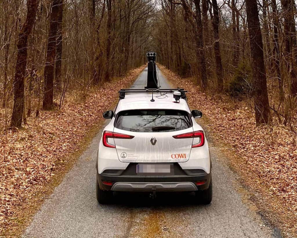
Hardware Tools for Road Asset Management- 360°Mobile Mapping Cameras
Fixing a 360° high-resolution camera to a vehicle is a perfect solution to all of the above.
The camera will be able to map out road networks, capture flaws, and only require a driver to escort it around town. Some other excellent benefits include:
- High 12k+ resolution imagery
- Large storage capacity
- Built-in system for data collection
- Weather and temperature resistant
- Easy to operate standalone unit
The key feature of this camera, however, is the powerful image quality.
Accuracy is measured by how the data is captured. For example, a high-resolution camera can not only photograph road names and signs from a distance but can do so while the vehicle is in motion.

Unlike LiDAR, which does not provide the photorealism that can discern specific details, a camera can.
Images from a 12k camera can provide surveyors and GIS with the proper lens by which to detect road deterioration and damage like potholes and cracking, as well as capture road signs in sharp detail. Lettering is easily identified, but also squiggles of graffiti, informing you which walls could do with a repaint!
This level of detail is very important in the very first stages of road asset monitoring.

Some excellent examples can be found here, with links to more detailed specifications.
Benefits of a 360° Camera for Roadside Asset Management
A 360° mobile mapping camera is ideal for data capture in every sector.
Local governments can travel further and map larger areas without the cost being an issue. Planning for new infrastructure is quicker because accurate data is provided from the beginning and is sourced using a much faster method.

Road asset monitoring and maintenance teams can then ensure the safety of citizens by having the information to keep infrastructure properly maintained and mitigate future potential risks.
Software Solutions for Road Asset Management
So the data capture with high-quality imagery of road assets is taken care of, what’s next?
Asset Tracking and Labeling
Online tools can be used to identify and analyze data. Road Doctor is a great example.
This tool is perfect for not only surveyors and engineers, but also geologists and geophysicists that require road and sub-surface data analysis – this software can simultaneously extract and analyze both.
The data results are then clearly presented on their free Road Doctor Viewer. This again only speeds up the road asset management process, and considering this is a continuous cycle, a streamlined system is highly sought after!
The software has six modules:
GPR (Ground Penetrating Radar)
GPR measures the subsurface. It is ideal for monitoring concrete and asphalt, as well as underground piping and cables. It is a geophysical method using radar pulses.
Diagnostics
This is a set of tools that allow the user, most often Road Engineers, to analyze Road Survey data. Data results can then be compared to predict the future longevity of structures and their bearing capacity.
Design
Again, mainly for Road Engineers, the design module’s objective is to create rehabilitation design as well as to provide analysis of the bearing capacity of new structures.
Surface Analysis
A tool designed to handle Lidar, laser scanner, and accelerometer data. It is exemplary when calculating the structural quality and surface of pavements.
Concrete
This module is excellent for locating defects and anomalies in concrete, such as cracking in bridges.
Rock
To assist Rock Engineers in estimating the stability of tunnel walls and roofing. It can also monitor the extent of rock excavation.
This kind of software is also an integral part of the road and road asset maintenance process. With a large storage system and compatibility across several survey devices and formats, it has an entirely scalable model to suit any project.
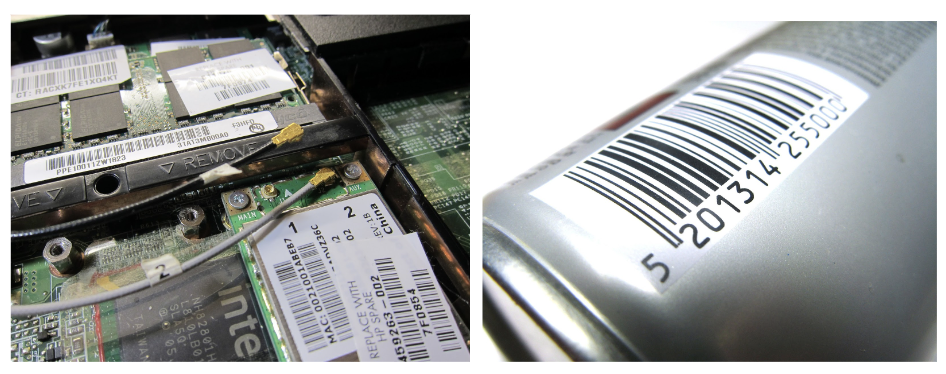
Asset Labeling
Asset labeling, or asset tagging, is exactly what you would expect – the process of affixing unique identification labels to assets. The asset is usually tagged with a barcode, to allow those monitoring it with a scanner to assess its condition and location.
Asset labeling is used for inventory in businesses to keep track of new and current stock and supplies. It is used across multiple fields, such as healthcare, education, defense, manufacturing, and, of course, in the process of road asset maintenance.
Eliminating the need for manual data entry, labeling is perfect for monitoring the asset’s present condition and history, as well as for predicting future maintenance. The data collected allows governments and businesses to make informed financial decisions, such as weighing the cost of repair against replacement.
An occasional issue in road assets, the tracking also assists in cases of misplacement or theft, and high-value assets are fitted with an anti-tamper barcode.
Asset tagging is a reliable and highly effective method of capturing data.
Previous manual identification procedures were often wrought with human error, leading to inaccuracies in stored data. This would not only waste time when the inconsistencies were located during quality assurance, but the data would then need to be re-sourced.
Following a Well-Structured Asset Labeling System
Identifying Category
A categorization system is key. Assets may be grouped according to need, by a multitude of variables, such as usage, cost, or area district.
Assigning Identification
The unique identification number as mentioned above. The code itself can relate to the type of asset, an internal department, or the owner. Often, asset tags will have an identifiable prefix to give those monitoring an immediate indication, such as to which department the asset belongs, for example, then the scan will provide further information.
Asset Label Type
Due to the incredibly variable nature and scale of assets, the solution cannot always be to simply attach a sticky label. Durable asset tags are assigned to items with more exposure, and security asset tags are allocated to high-cost/high-risk items.
Storage, weather exposure, the longevity of the asset, and many other characteristics need to be taken into account when a label is issued.
Label Affixed
This can again vary based on the type of label; some are permanent, and some are not. Company policy can occasionally need to be taken into account when using pressure-sensitive adhesive or mechanical attachments.
Data Entry
Once tagged, the asset is entered into a system to be monitored. The data included will have the below, with additional information as required:
- Asset ID number
- Serial/model number
- Date of acquisition
- Location
- Value
- Asset status
- Manufacturer or vendor information
Data Verification
The data, once entered, goes through quality assurance. Key identifiers like the above are confirmed and checked for accuracy. A consistent asset labeling process ensures that assets monitored are classified, that the assets are locatable, and that a regular maintenance schedule can be implemented.
Data verification is also important for disposal. Some assets, such as those within the IT sector, have certain compliance and regulations to follow to ensure against data breaches. This is referred to as an ‘accurate and verifiable chain of custody.’

Conclusion: Why Road Asset Management Matters
Road and road asset management relate ultimately to the growth of the economy. With this in mind, governments and municipalities are keen to keep the bottom line as favorable as possible.
Spending upfront on the right equipment to get the best results ensures an overall smooth and highly efficient operation, which results in significant long-term savings.
A maintenance policy where damage is captured and communicated early, with maintenance teams having access to accurate, prime quality imagery, allows issues to be addressed before they can cause further deterioration.
The annual savings in pavement management alone following these steps are forecast to be between 20% and 60%.
Overall, a correct and efficient procedure will improve the utilization of resources, reduce unnecessary costs, increase the lifespan of assets, and this will positively impact the bottom line.
Ensure your road asset maintenance starts with accuracy from the outset.
If you are looking for a high-resolution 360º data capturing tool to produce a clear view of roadside assets for maintenance or monitoring, the line of Mosaic mobile mapping cameras is the new industry standard.
Contact our team today to learn more.


