
The role of 360º mobile mapping cameras in creating 3D maps and digital twins
It is no longer only about maps
In today’s digital ecosystem, the demand for accurate and up-to-date digital representations of metropolitan areas is on the rise. And demand is increasing for urban insights with 360 cameras over other types of data collection devices. Some of us have already come across Google Street View or Apple Maps vehicles equipped with 360º cameras. We see them traversing cities and capturing detailed imagery for integration into their mapping services.
But the detail and flexibility with which the data for digital twins can be captured go far beyond maps. The digital twin is the ultimate tool for cost-effective infrastructure development, making it invaluable for urban planners and city administrations. It enhances planning processes, facilitates well-informed decision-making, and streamlines stakeholder involvement.
Having accurate and highly detailed 3D city models at hand also allows the corresponding authorities to simulate and assess future development of buildings and city infrastructure. Precise geospatial information of dense cities, together with high-definition, true-to-life digital twins of every single part of it, also enhances risk assessment or disaster prevention planning. And as you are going to read in this article, the benefits of detailed 3D modeling are slowly heading beyond the limits of municipalities and cities to the level of entire countries.
Understanding smart cities
Smart cities are urban environments that utilize cutting-edge technologies to better understand and thereby enhance the quality of life for their residents. These cities integrate multiple facets, including transportation, energy, waste management, communication, and public services, into a cohesive and interconnected ecosystem. The goal is to optimize resource allocation, improve efficiency, and create sustainable urban environments that cater to the needs of their inhabitants.
For this level of interoperability and data exchange between different stakeholders and systems for smart city initiatives, CityGML (City Geography Markup Language) is commonplace. It is an open-source platform for collaboration and effective utilization of 3D data with varying Levels of Detail (LODs).
See our article about 7 Smart Cities in the World that are Stepping Up in Big Ways.
The role of 360º mobile mapping cameras
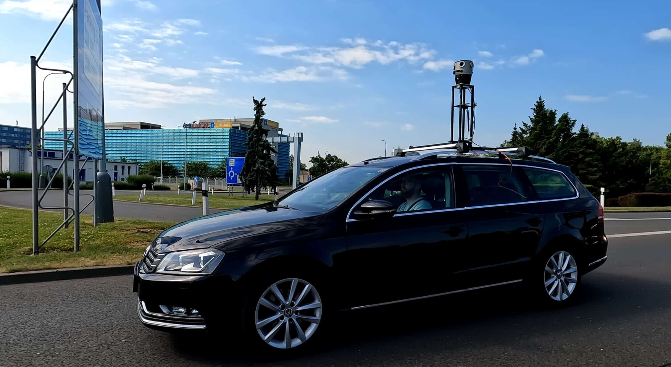
The role that 360-degree mobile mapping cameras play in the creation and development of smart cities is, naturally, crucial. What used to require a disproportionately higher amount of time can now be done by one sweep. Now, with the 360º camera mounted on a vehicle, one can capture all the necessary details of an entire city. Speed, efficiency, and precision in data collection have made 360-degree mobile mapping cameras the go-to solution for large-scale projects.
How can 360º cameras help a city to become “smart”?
Mobile mapping vehicles can be equipped with a range of sensors depending on the scope and character of the project, which typically include a combination of:
- Positioning (GNSS, GPS) to collect rich geospatial data
- LiDAR to produce dense and highly precise point clouds. It is a Light Detection and Ranging method for capturing 3D data. It works by emitting laser beams and measuring the reflected light.
- A 360º camera to put color and detailed texture information into the point cloud
- More remote sensing systems
Why 360-degree mobile mapping cameras
- Efficiency and speed: By mounting 360-degree cameras on vehicles, real-time 3D data can be collected quickly and efficiently. And, like with the Mosaic X & Mosaic 51, there is little to almost zero training of the personnel. 360-degree cameras enable the mapping of large areas to be completed in a relatively short amount of time. Visit this Mosaic case study about capturing high-resolution images faster and cheaper!
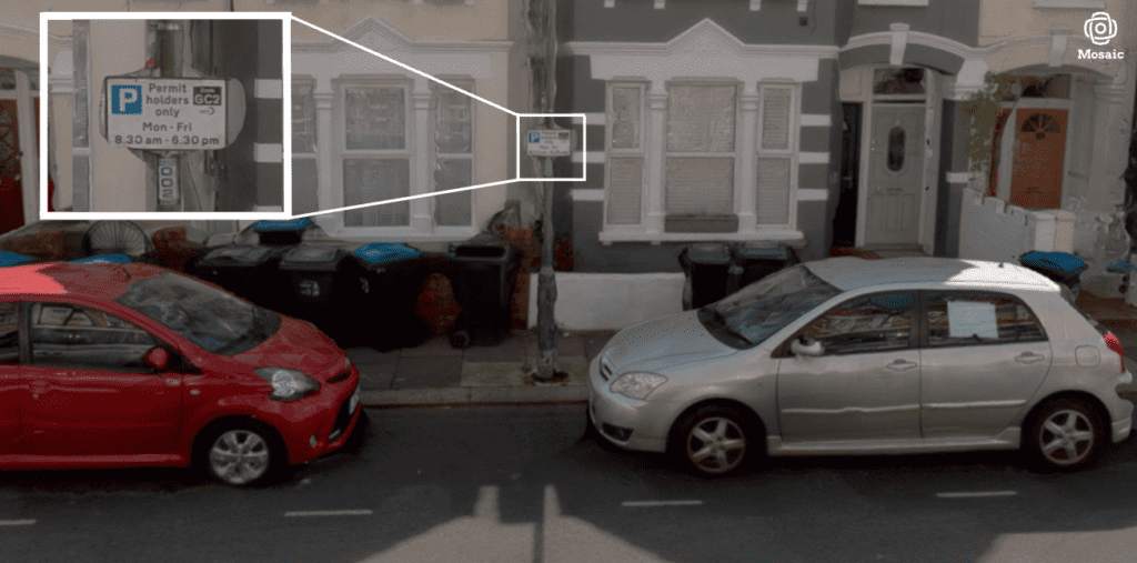
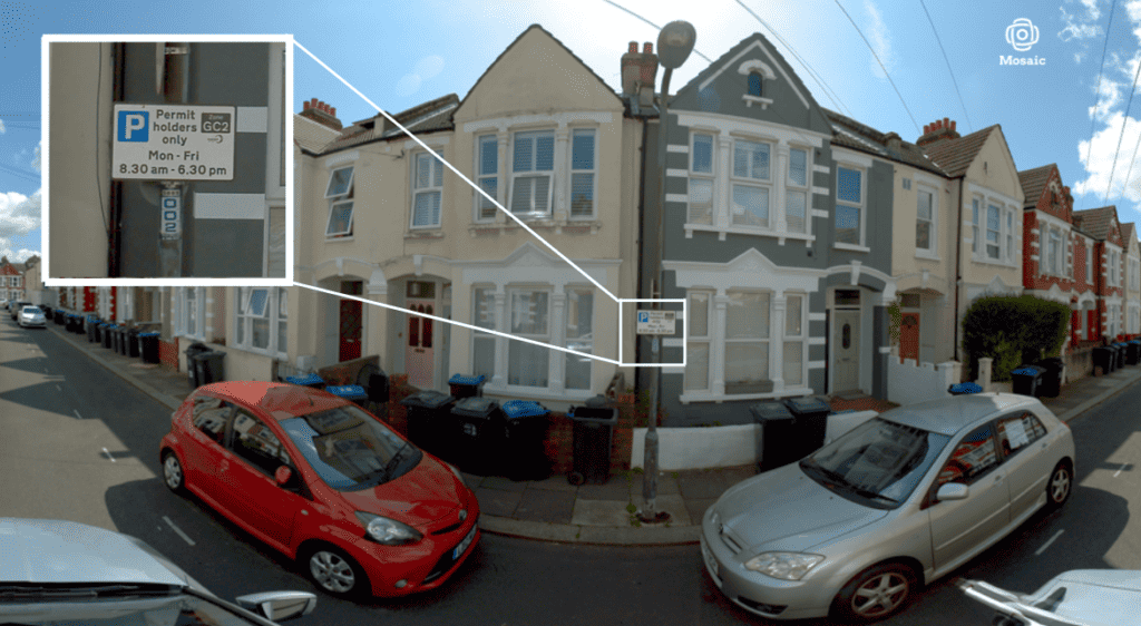
- Accuracy and detail: The 360º mobile mapping cameras capture a comprehensive view of the surroundings, including topographical features, natural landmarks, buildings, electrical grid infrastructure, streets and traffic signs, and other objects, ensuring that no details are missed. This level of detail is crucial for creating accurate 3D maps and digital twins, providing a photo-realistic representation of the entire urban landscape.
And the best part about having precisely geo-referenced 3D representations is that the information about the color and texture comes from high-definition images. 360ºmobile mapping cameras with high resolution open an immeasurable number of future opportunities for different focus groups. Just zoom in and explore in detail any type of asset that has been captured within the creation of the smart city model. Check out the road surface, the state of road signs, as well as the power grid, etc. Don’t forget the effect on the decreasing ratio of human resources compared to artificial intelligence, which is necessary for interpreting the 3D data captured.
- Real-time updates: With 360-degree cameras mounted on vehicles, mapping companies can continuously update their datasets to reflect the ever-changing urban environment. This allows for timely information on new infrastructure developments, road updates, and changes in urban landscapes.
Digital twin of Vienna
A brief statistic might make it easier to imagine a 360-degree mobile mapping project of an entire city. Let’s use a good practice example from Austria. The City of Vienna had a project to reorganize public space, as well as management structures and public activities. The entire city of Vienna was mapped by mobile mapping vehicles. Concerning the mobile mapping campaign, the following outputs were defined:
- 77 days of data collection
- 4200 km road network (total road network of Vienna)
- 21 million images
- ~100 TB data
- <10 cm spatial accuracy
- 3m distance between images
The data obtained was geo-referenced, anonymized, and made available to the departments of the Vienna City administration in a web-based image data viewer for future local inspections or statements. Learn more about the urban insights with 360 cameras here. (source)
Smart Germany
The rapid progress of data capture technologies that allow large-scale, aerial Lidar scanning – such as Geiger-mode Lidar (GmL) or single photon Lidar (SPL), together with recent advancements in information technology – such as increased processing capabilities through cloud computing and artificial intelligence brought us closer to a project the scale of which goes beyond an average imagination: a digital twin of the size of not a house, not a street, not a city, but an entire country – nationwide digital twin with unprecedented potential to streamline collaboration across various resorts on federal and state level.
And the answer is yes, it does, if you are asking the same question as we were, if this is going in the direction to destination Earth. Destination Earth is a flagship initiative of the European Commission to develop a highly accurate digital model of the Earth on a global scale to monitor, simulate, and predict the interaction between natural phenomena and human activities. Apparently, when it comes to geodata, the sky’s the limit. (source)
Mosaic 360º cameras
As for now, Mosaic stands with its feet on the ground. Or better to say, with the wheels of their vehicles on the ground. With vehicles armed with best-in-class, high-definition 360-degree cameras mounted on the car rooftops, collecting 360 data at highway speed. Mosaic 360° cameras are robust, standalone units that allow street-level capture of images of your sites, streets, and towns to make better-informed decisions. There are solutions to every level of detail required by various projects.
- Image resolution of 12.3K – 20K, depending on the model
- Capable of achieving the desired accuracy with internal GPS or integration with external devices
- Complements LiDAR MMS
- Colorizes point clouds (the Mosaic X integrates with Riegl LiDAR laser scanners).
While fine-tuning a post data processing software internally, Mosaic 360º mobile mapping cameras produce non-vendor lock-in data to best cater to the needs of our customers’ projects. If you’d like to learn more about how Mosaic can help your site, street, or even a town to become smarter, get in touch.
From smart cities to the world that is smart?
Smart urban transformation, driven by the integration of continuously developing surveying technologies and data-driven solutions, offers a growing number of benefits for cities and their citizens. Being able to build precise, geo-referenced, and highly lifelike digital twins brings an unprecedented level of collaboration and the ability to simulate all possible alternative futures of a neighborhood or a city.
This, of course, will allow smart urban planning to continue to increase safety and security, enhance connectivity, grow sustainability, and stimulate innovation. What started with a smart city in the past might one day lead to a smart world!
The question of whether the world will utilize the data wisely and become smarter remains unanswered. But the data will be available, and we can’t wait to be a part of it.
Looking to learn how Mosaic cameras can help you? Contact us here!


