
Setting new standards in precision and efficiency for Mosaic customer Mapersive, redefining urban mapping and geospatial analysis
Who is Mapersive and Geomatic?

Mapersive
Mapersive is a cutting-edge SaaS solution that revolutionizes the extraction and visualization of geospatial data. As Iwu Emmanuel, the Product Manager at Mapersive, states,
“Mapersive is an innovative solution that harnesses massive collaboration and cutting edge technologies in GeoAI and computer vision to bridge the gap between data providers and decision makers by offering them a comprehensive solution to rapidly and precisely extract geospatial data from extensive street-level imagery.”
Emmanuel emphasizes the company’s mission to leverage technology for better urban planning and resource management,
“Mapersive aims to redefine how geospatial data is utilized in urban development.”
Geomatic
Geomatic is a prominent GIS company located in Morocco and across northern Africa, which has been offering a range of services, including geospatial data analysis, urban planning, and infrastructure maintenance for over 30 years. They are the exclusive distributor of ESRI products throughout the region.
Geomatic was the original breeding ground for Mapersive, and the two companies now collaborate on projects together. With Geomatic’s 30+ years of experience in the field and Mapersive’s solution, they are capable of extending users’ capabilities and improving their offerings to existing and new clients.
Challenges Faced
What are the challenges Mapersive’s clients were facing?
Mapersive clients encountered substantial challenges in acquiring up-to-date and high-quality geospatial data, which is essential for effective urban planning, monitoring, and infrastructure development, while also ensuring cost efficiency.
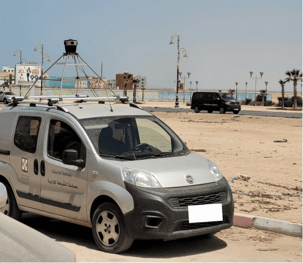
This is where Mapersive comes as an innovative SaaS solution, and the Mosaic 51 Camera played the indispensable role of providing our clients with extremely high-quality and reliable street-level imagery for use in the Mapersive platform.
Emmanuel illustrates this struggle, stating,
“Before acquiring the Mosaic 51 camera system, obtaining detailed and accurate geospatial data was a daunting task, often leading to inefficiencies in planning and execution.”
Iwu Emmanuel
The limitations in data acquisition not only affected the quality of urban projects but also posed a barrier to innovation in GIS applications.
In particular the following industries presented unique challenges for Mapersive:
Surveying and GIS
One of the main challenges for surveying and GIS tasks was acquiring high-resolution, accurate geospatial data in a timely manner.
Urban Planning
In urban planning, the challenge was to obtain a detailed and up-to-date view of cityscapes and infrastructures.
Infrastructure Maintenance
Maintaining urban infrastructure requires accurate and regularly updated data. Prior to using Mosaic 51 cameras, capturing this level of detail across vast urban landscapes was a significant challenge.
Mission and Solution
What was Mapersive’s Mission?
Mapersive’s primary mission was to revolutionize the way geospatial data is collected and utilized in urban planning and GIS applications.
Iwu Emmanuel explains,
“Our goal was to enhance data collection and make urban planning processes more efficient. We needed technology that could capture detailed geotagged street-level imagery.”
Solution Validation Phase and Selecting Mosaic 51
“The sample imagery from Mosaic 51 stood out due to its superior quality and robust GNSS capabilities. Users typically can achieve sub-metric distance measurements and absolute point measurements with an error margin of approximately 2 to 3 meters.”
Iwu Emmanuel
During the solution validation phase, Mapersive was dedicated to sourcing high-quality test data for their solution. They reached out to several industry leaders in mobile mapping and 360-degree/panoramic imagery, seeking sample datasets to evaluate the options. Among the various responses, Mosaic 51’s imagery was particularly impressive, standing out for its superior quality and robust GNSS capabilities. This distinction was crucial as it enabled the acquisition of high-quality images with precise and reliable GNSS information, a key requirement for Mapersive’s data processing pipelines. This phase was pivotal in Mapersive’s decision to select Mosaic 51 as their recommended camera system.
How did Mosaic 51 provide a solution?
The Mosaic 51 camera system emerged as the ideal solution for Mapersive’s needs. Its high-resolution imaging capabilities and robust design were perfectly suited for the challenging environments in which Mapersive’s clients operate. Emmanuel notes,
“Mosaic 51’s technology was a game-changer. It allowed us to capture incredibly detailed 360-degree images, even in the most demanding conditions.”
Iwu Emmanuel
Implementation and Usage
The integration of Mosaic 51 into Mapersive’s operations marked a significant advancement in their data collection process. Emmanuel describes the transition as “seamless and efficient,” highlighting the ease with which their teams adapted to the new system.
Mapersive clients and the operators of Mosaic 51 cameras are primarily local city governments within Morocco. Mapersive recommends the Mosaic 51 camera to ensure the best results with their solution, a choice informed by their extensive testing.
Mapersive’s clients now own two Mosaic 51 camera systems.
They provide training on how to effectively operate and utilize these cameras for gathering the imagery needed for the Mapersive platform.
“Remarkably, we required almost no training to use the Mosaic 51 or to instruct our clients in its usage,”
reported Emmanuel
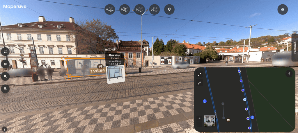
Mapersive’s SaaS solution processes 360° imagery, which their clients utilize for visualization, navigation, and the collection of accurate, customized, and up-to-date spatial data. This data is instrumental across various departments for the management and inspection of public assets.
“The images collected using Mosaic 51 are utilized in our platform for various purposes including navigation, data extraction, analysis, and interoperability with third-party industry GIS applications.”
Iwu Emmanuel

Results and Impact
Significant Improvements and Benefits
Mapersive has utilized Mosaic 51 in various projects, ranging from urban mapping to infrastructure analysis, demonstrating its versatility. The robustness of the Mosaic 51 system, capable of withstanding extreme temperatures and conditions, has been particularly beneficial in Morocco’s varied climate.
Since implementing the Mosaic 51, Mapersive has observed substantial improvements in their data collection and processing:
Time Efficiency
Mapersive’s clients have experienced a notable reduction in the time needed for data capture and processing. This efficiency is attributed to the Mosaic 51’s high-resolution and effective imaging capabilities.
“Clients have noted that using Mosaic 51 reduces the time needed for data capture and processing due to its high-resolution and efficient imaging capabilities.”
Iwu Emmanuel
Quality and Accuracy
Geomatic reports that their clients have observed that when using the Mosaic 51 mobile mapping system, with its default GNSS, they can achieve sub-metric distance measurements and absolute point measurements with an error margin of approximately 2 to 3 meters.
Iwu Emmanuel highlights,
“The consistent quality and accuracy of data captured by Mosaic 51 make it a reliable choice for our clients.”
This reliability is crucial for ongoing projects that require precise geospatial data.
Read more about how high resolution imagery and precise geospatial data is helping Mapersive‘s platform uses AI-assisted feature extraction and asset recognition on 360-degree street view imagery.
Enhanced Urban Mapping
The advanced imaging technology of Mosaic 51 has significantly improved Mapersive’s urban mapping and infrastructure analysis projects, making it a valuable asset for extensive geospatial data collection.
As previously mentioned, the following 3 areas within urban mapping were previously suffering from challenges, that the implementation of the Mosaic 51 camera systems has greatly enhanced:
Surveying and GIS
The integration of Mosaic 51’s advanced imaging technology significantly elevated their geospatial data acquisition capabilities. With its 12K resolution cameras, Mosaic 51 provides unparalleled clarity and precision, greatly enhancing Mapersive’s ability to analyze urban features and landscapes for GIS applications.
Urban Planning
The Mosaic 51 cameras, known for their robustness and adaptability, have revolutionized their approach to urban planning. They allow for a detailed and current representation of cityscapes and infrastructure, enabling more informed and efficient planning and development decisions.
Infrastructure Maintenance
The addition of Mosaic 51’s high-resolution cameras has transformed the urban infrastructure maintenance process. Previously, obtaining detailed data across vast urban areas was challenging. Now, these cameras facilitate precise monitoring and more strategic maintenance planning of urban assets.
Feedback from End-Users and Stakeholders
End-user Feedback about Mosaic 51
End-users and stakeholders have been highly appreciative of the data quality, ease of use, and the accuracy enabled by the Mosaic 51. This positive feedback emphasizes the system’s efficiency in improving urban data collection and processing.
Mapersive’s Future Plans with Mosaic 51
Mapersive envisions Mosaic 51 continuing to play a pivotal role in their future projects, particularly as they venture into more complex mapping and data analysis endeavors. The organization is open to additional features, such as integrated image stitching and GNSS Ground Control Points (GCPs) integration, to further enhance user experience with the Mosaic 51 system.
“We see Mosaic 51 continuing to be a key recommendation for our clients, especially as we expand into more sophisticated mapping and data analysis projects.”
Conclusion
Mapersive’s choice of the Mosaic 51 camera system marks a groundbreaking leap in capturing high-resolution, accurate geospatial data, propelling their urban mapping and infrastructure analysis into a new era of precision and efficiency. The Mosaic 51 camera stands as a beacon of technological excellence, proving to be an invaluable asset for organizations deeply entrenched in geospatial data collection. The resounding positive feedback from end-users and stakeholders is a testament to the transformative impact of the Mosaic 51 camera on urban data collection and processing.
As Mapersive looks forward, the Mosaic 51 360-degree systems stand as a cornerstone of their future endeavors, especially as they dive into the realms of advanced mapping and sophisticated data analysis.
Considering potential advancements like integrated image stitching and GCPs enhancements, Mapersive and its partners anticipate a future where their capabilities are significantly augmented by the features of the Mosaic 51.


