
Supercharge ESRI’s ArcGIS Pro and Web App Builder with Mapillary’s plugin and imagery from Mosaic camera systems. Start with the highest resolution images imaginable and end with free hosting, anonymization, and segmentation.
How to get 360º Imagery from Mapillary into ESRI’s ArcGIS
In our previous article, we showed you steps 1 – 5, which detailed how to capture, process, upload, and extract data from 360º imagery collected with Mosaic cameras within Mapillary.
We also talked about all of the features and object classes that Mapillary can extract, including:
- Automatically detect 65 object classes accessed through API
- Download 1,500 different traffic sign classes &
- 42-point feature classes via the user interface
We continue the journey now to give ArcGIS users insight into how to get their data into their ArcGIS account – whether ArcGIS Pro or Web App Builder.
LET’S GO!
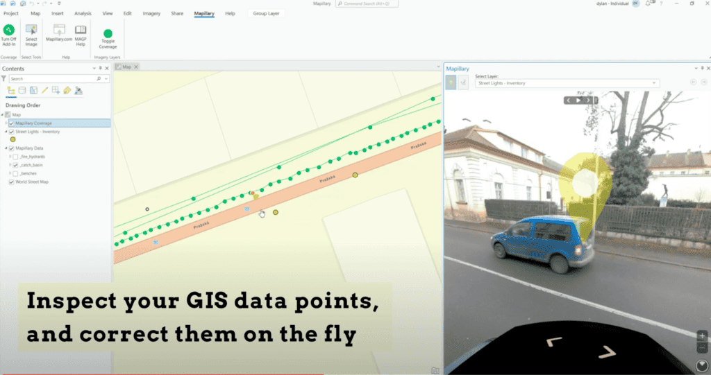
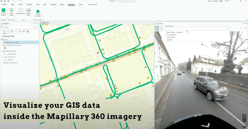
Step 6: Integrate Data into ArcGIS
More details at the bottom of this article for integrating data into ArcGIS from Mapillary.
Mapillary Integration with ESRI for ArcGIS Pro & ArcGIS Web App Builder
There are several options for viewing 360º street view imagery within ArcGIS products, but today we’re going to focus on Mapillary and why it is beneficial to use the integration from Mapillary into ArcGIS rather than some of the other options available.
With Mapillary, users get all of the following features and abilities:
- Free hosting – no need to pay or to calculate how many tokens to use
- Anonymization – stay GDPR compliant and keep residents safe
- Segmentation – use 360 imagery to find and identify dozens of street assets and 1,500 types of traffic signs.
When you integrate Mapillary with ArcGIS Pro, you unleash a world of visual exploration right at your fingertips. With this add-in, you dive into a vivid, street-level imagery experience on your desktop.
Let’s step back a few and dive into ESRI, ArcGIS Desktop Pro, and ArcGIS Web App Builder, to see what it all is, who is using it, and why, and the power that viewing 360 street view data within ArcGIS can bring to its users.
Introduction: Navigating a New Dimension: The Power of 360 Imagery in GIS
In the realm of Geographic Information Systems (GIS), the visualization of data is not just about static maps and abstract numbers; it’s about understanding our world in its full spatial context. Enter 360-degree street view imagery: a revolutionary visual tool that enables users to immerse themselves in a location without leaving their desks. This panoramic imagery offers a comprehensive view that goes beyond the traditional top-down mapping perspective, giving GIS professionals and stakeholders the ability to examine locations with lifelike clarity.
Central to our discussion is the presumption that users are looking to leverage Mapillary, a service that allows for the integration of user-generated 360 street view images into ArcGIS. Mapillary not only enhances the GIS experience but also extends the capability to customize and update street-level imagery. This is particularly beneficial for those who require the most current and location-specific views, which may not always be available through commercial providers like Google Street View.
As we explore the intersection of ArcGIS tools with the vibrant detail of 360 imagery, we invite you to consider the possibilities that open up when you step into the panoramic world of Mapillary—a world where every angle is a new opportunity for discovery.
Understanding ESRI and Its Flagship Tools
What is ESRI?
Environmental Systems Research Institute, better known as ESRI, is a pioneer and enduring leader in the field of geographic information system software. Founded in 1969, ESRI has been instrumental in transforming the way spatial data is utilized, serving a diverse range of industries, from logistics to environmental conservation. The company’s software enables users to create, manage, analyze, and map all types of geospatial data, allowing for informed decision-making based on geographic context.
Overview of ArcGIS Desktop Pro and Web App Builder
ArcGIS Desktop Pro is ESRI’s advanced desktop GIS application. It’s a powerful, single-user tool designed for creating beautiful maps, performing spatial analysis, and managing data within a modern, intuitive interface. It allows for the rendering of large datasets and complex analyses at unprecedented speeds. The application is fully integrated with ESRI’s ArcGIS platform, meaning that it can share and manage data in the cloud or on-premises with seamless ease.
ArcGIS Web AppBuilder, on the other hand, is a browser-based tool that enables the creation of interactive web applications without any coding. It offers a drag-and-drop experience for users to build custom applications that can run on any device. With its rich set of widgets and themes, users can tailor their applications to meet specific project needs and make their spatial data more accessible and user-friendly.
In the following sections, we will explore who uses these tools, how they are applied in various fields, and the benefits of integrating 360º imagery to enrich the GIS experience.
The Users and Uses of ArcGIS Pro and Web App Builder
Who uses ArcGIS Pro and Web App Builder?
The versatility of ArcGIS Pro and Web App Builder caters to a broad spectrum of users. Urban planners, environmental scientists, public health officials, logistics managers, and even marketing analysts turn to these tools for their geospatial needs. Educational institutions use them for research and teaching, while government agencies rely on them for infrastructure management and emergency planning. Essentially, anyone who needs to visualize, analyze, or manage spatial information is a potential user of ArcGIS Pro and Web App Builder.
Common use cases of these tools in various industries
ArcGIS Pro is pivotal for tasks that require advanced spatial analysis or a robust suite of geoprocessing tools, such as site selection, terrain modeling, and spatial statistics. In urban planning, it helps in zoning analysis and public space design. Environmentalists use it for habitat mapping and tracking changes in land use. In the realm of public health, it’s utilized to map disease outbreaks and plan health services.
Web App Builder has found its niche in making GIS applications accessible to a non-technical audience. For instance, municipalities use it to create interactive zoning maps for the public, while conservation groups build apps to engage citizens in environmental monitoring. Logistics companies use it to track vehicle movements and optimize delivery routes.
The Value of 360 Imagery in ArcGIS
How 360 imagery enhances GIS tasks in ArcGIS Pro and Web App Builder
The integration of 360-degree imagery into ArcGIS tools adds an immersive dimension to spatial analysis. It enables users to virtually visit any site, getting a feel for the place without the time and expense of travel. In ArcGIS Pro, 360 imagery can be used for accurate feature extraction, allowing analysts to pinpoint and catalog elements like signage, infrastructure, and vegetation. For Web App Builder, it provides end-users with an intuitive way to explore areas of interest, enhancing public engagement and stakeholder communication.
Examples of 360 imagery applications in urban planning, environmental monitoring, etc.
Urban planners might use 360º imagery to assess the impact of proposed developments on the surrounding environment or for virtual public consultation on new projects.
Environmental scientists can use it to document and monitor changes in ecosystems over time, providing a vivid record that can be more compelling than traditional photographs.
Emergency services can use panoramic images to plan evacuation routes and disaster response strategies.
Challenges with 360º Street View Imagery in ArcGIS
Identifying the difficulties users face with integrating and viewing 360 imagery
While integrating 360 imagery into ArcGIS tools provides many benefits, it also comes with challenges. Users often encounter difficulties with data size and management, as 360 images are larger and more complex than traditional images. Compatibility issues may arise when trying to integrate imagery from various sources. Moreover, keeping the street view data up to date can be cumbersome and expensive, especially for areas that change frequently.
Discussing limitations related to accessibility, compatibility, and data currency
Accessibility is a key concern; not all regions have readily available street view imagery, which can limit geographic analysis. Compatibility issues often arise from the diverse formats of 360 imagery and the GIS tools used to process them. Furthermore, ensuring that the imagery reflects the current state of the environment is a persistent challenge. Data may become outdated quickly, especially in rapidly developing areas, leading to potential inaccuracies in analysis and decision-making.
Solutions for Integrating 360 Street View Imagery
Discussing built-in features and add-ins like the Google Street View add-in for ArcGIS Pro
To address these challenges, ESRI and third-party developers offer various solutions. For instance, the Google Street View add-in for ArcGIS Pro enables users to access Google’s extensive street view data directly within the GIS environment. This add-in simplifies the process of viewing and analyzing 360 imagery alongside traditional GIS datasets.
Alternatives for integrating street view imagery and how they compare
Apart from Google’s offerings, there are other platforms, such as Mapillary, that provide alternative sources of street view imagery. These platforms often offer additional features, like community-sourced updates, that can keep the spatial data fresher. Furthermore, some of these services provide APIs that facilitate integration with ArcGIS tools, allowing for a smoother workflow and expanded imagery access.
Mapillary’s Edge in ArcGIS Integration
Advantages of using Mapillary over other solutions
Mapillary stands out for several reasons. Its commitment to free hosting alleviates the financial burden on users, particularly important for small organizations or individual researchers. The platform’s focus on privacy through anonymization is critical in today’s data-sensitive world. Moreover, Mapillary’s segmentation tools enable the extraction of meaningful spatial data from imagery, enhancing the GIS analytical capabilities.
Step-by-step guide on integrating Mapillary with ArcGIS tools
To integrate Mapillary with ArcGIS, users can follow a series of straightforward steps. First, access the Mapillary plugin from the ESRI marketplace and install it in ArcGIS Pro. Once installed, users can link their Mapillary account and begin accessing street view imagery. The plugin allows users to visualize the Mapillary coverage, explore images, and extract vector data from the images directly into their GIS projects.
Mapillary’s integration with ArcGIS Pro offers a dynamic experience. It overlays global imagery on your map, allowing seamless transitions from bird’s eye to street-level views. You can edit and compare data, enhancing accuracy. The platform provides historical insights for urban planning. This integration streamlines GIS workflows, making it a vital tool for smarter cities and saving time in data collection.
For all of the details and a click-by-click guide, we suggest checking out how to move data from Mapillary into ArcGIS Pro and Web App Builder. Users can find out more information here. Detailed documentation on how to set it up can be found here.
The Importance of Collecting Your Own Data
Why collecting fresh, custom data is crucial for GIS professionals
Relying on third-party data sources like Google Maps can lead to issues with data recency and relevance. By collecting their own street view imagery, GIS professionals can ensure that their spatial analyses are based on the most current and applicable data. This is particularly vital for time-sensitive projects such as environmental impact assessments or infrastructure development, where changes in the landscape can have significant implications.
How Mapillary facilitates the collection and integration of up-to-date street-level imagery
Mapillary empowers users to collect and upload their own 360 imagery, providing a platform that supports community-driven data collection. This approach democratizes the data collection process and enriches the available spatial data. For ArcGIS users, this means they can maintain a library of custom, up-to-date imagery that is tailored to their specific project needs.
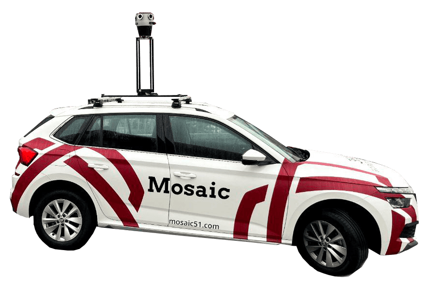
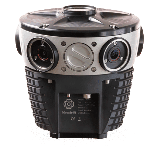
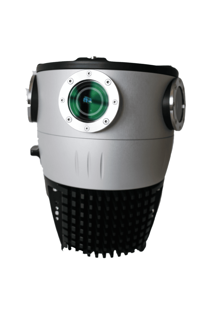
Ease of Data Collection with Mosaic 360 Mobile Mapping Cameras
In the world of GIS, the freshness and accuracy of data can make a significant difference in the outcomes of spatial analysis. This is where the ease of collecting your own data with a 360 mobile mapping camera like the Mosaic 51 and Mosaic X becomes invaluable.
Standalone Systems for Hassle-Free Operation
The Mosaic 51 and Mosaic X cameras are designed to be standalone systems, meaning they come with built-in GPS for geolocation, a GPU+CPU for processing, and onboard storage for data capture. This integration eliminates the need for additional devices during the data collection process, streamlining operations and reducing setup time.
Geo-Referencing and Timestamping for Precision
As the cameras capture 360 imagery, each data point is automatically geo-referenced and timestamped. This ensures that the data is not only accurate but also has the spatial-temporal context necessary for detailed GIS projects.
Single Operator Efficiency
The operational efficiency of the Mosaic cameras is such that only one operator or driver is needed to begin data collection. This significantly reduces the manpower and the associated costs, making it an economical choice for projects of any scale.
Intuitive Control with a WebUI
Control of the Mosaic cameras is facilitated through a simple-to-use web-based User Interface (WebUI). The intuitive nature of the WebUI means that training time is minimal, and operators can quickly become proficient in using the system. There’s no need for special certifications beyond a standard driver’s license, lowering the barrier to entry for potential users.
Frequent and Reliable Data Collection
The user-friendliness and reliability of the Mosaic 360 cameras empower users to collect data swiftly and reliably. With the ease of repeated captures, street view imagery can be kept as fresh and current as possible, enhancing the value it brings to GIS applications.
Collecting your own data with tools like the Mosaic 51 and Mosaic X not only simplifies the process but also ensures that the data used in your ArcGIS projects is of the highest fidelity—allowing you to map the world as it changes, with confidence and precision.
Bringing Your Maps to Life with Mapillary and ArcGIS
The integration of Mapillary’s 360 imagery into ArcGIS tools represents a significant leap forward in the field of geospatial analysis. By blending the immersive detail of street-level photography with the powerful analytics of ArcGIS, professionals across a multitude of disciplines can gain unparalleled insights into the spaces they study and manage. Mapillary’s free hosting, emphasis on privacy through anonymization, and advanced image segmentation capabilities present compelling advantages, especially when compared to traditional street view services.
The importance of accurate and up-to-date geospatial data cannot be overstated. It is the foundation upon which critical decisions are made, from urban planning to environmental conservation. With the ability to integrate custom-collected imagery, ArcGIS users are empowered to ensure that their analyses, presentations, and decisions are based on the most current and relevant visual data available.
Explore the World in Panoramic Detail
We invite you to experience the power of 360-degree imagery within your ArcGIS projects. Whether you are a seasoned GIS professional or new to the field, Mapillary’s integration with ArcGIS tools opens up a world of possibilities. Step into the scene, analyze your data within its true context, and communicate your findings with compelling visualizations.
Take action today and transform your geospatial projects with the richness of street-level imagery. Discover the Mapillary difference and see your world from every angle.
Learn more about our cameras and request information below in the contact form. We’re happy to get on a call with you when you’re ready to discuss your 360 mobile mapping camera needs!


