
Find out how to get free asset identification and segmentation for your 360º street view images from Mapillary, starting with high-resolution imagery from Mosaic camera systems
Step by Step: How to get Mosaic 360º Imagery into Mapillary
Prep:
Follow Jeffrey Martin, CEO and Co-founder of Mosaic, through the simple process of getting 360º street view data into Mapillary. In this case, using data he collected with our Mosaic mobile mapping camera system.
LET’S GO!

Step 1: Drive and capture high-resolution street view imagery
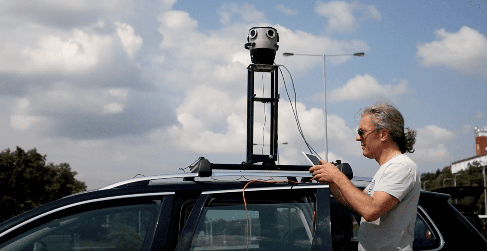
The Mosaic X fits atop any standard vehicle with ease!

Step 2: Upload the data to your computer.
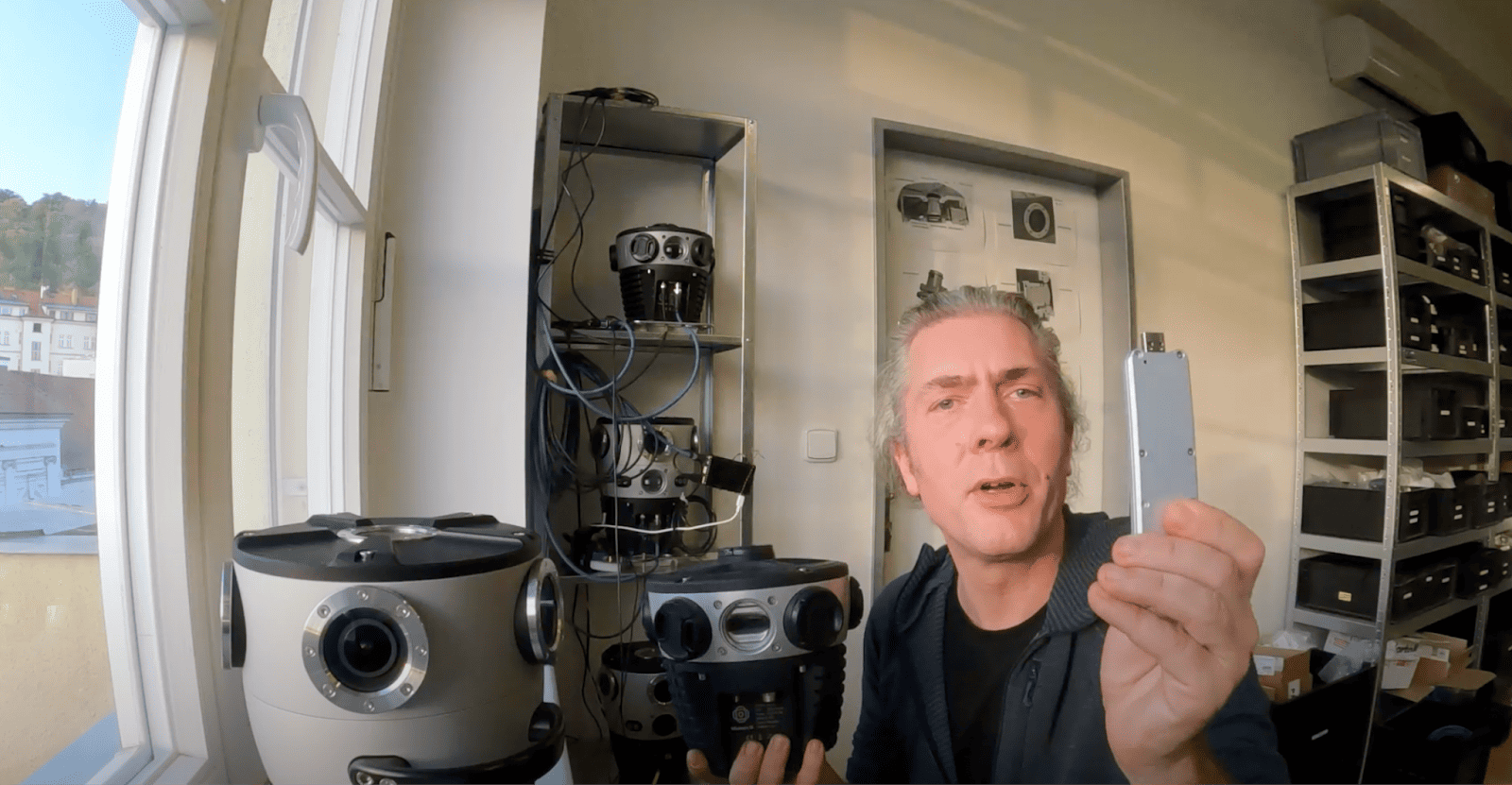
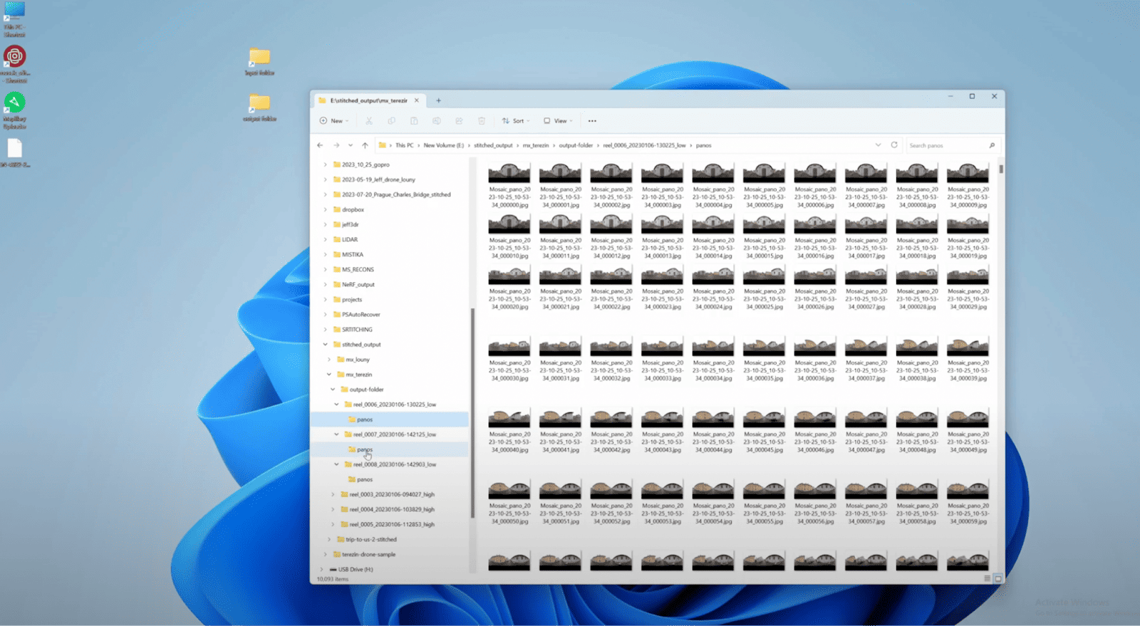
Step 3: Stitch images
(aside: check the map before the images are uploaded to see the ‘before’)
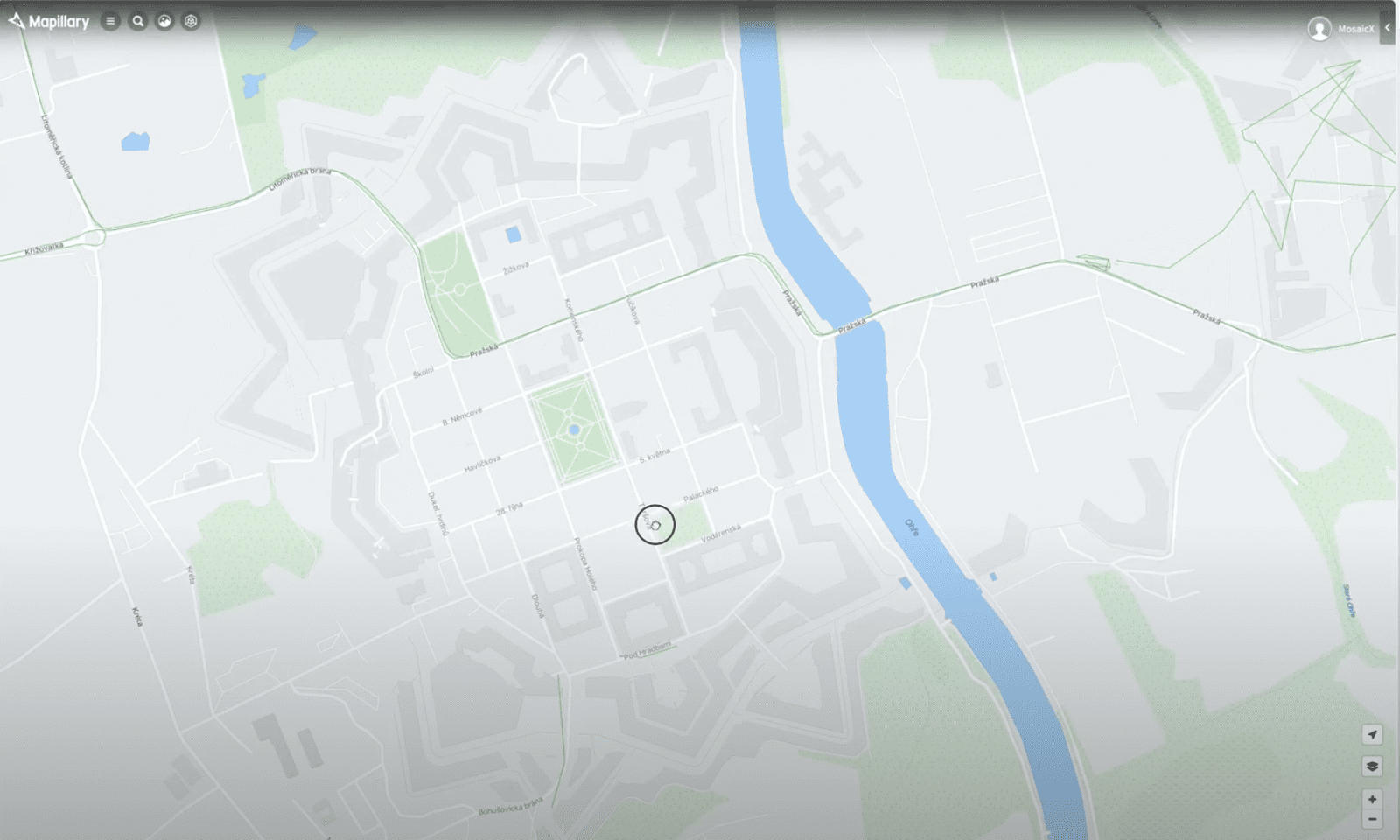
Before the Mosaic data was uploaded to Terezin, only one single road had any images through it.
Step 4: Upload images to Mapillary
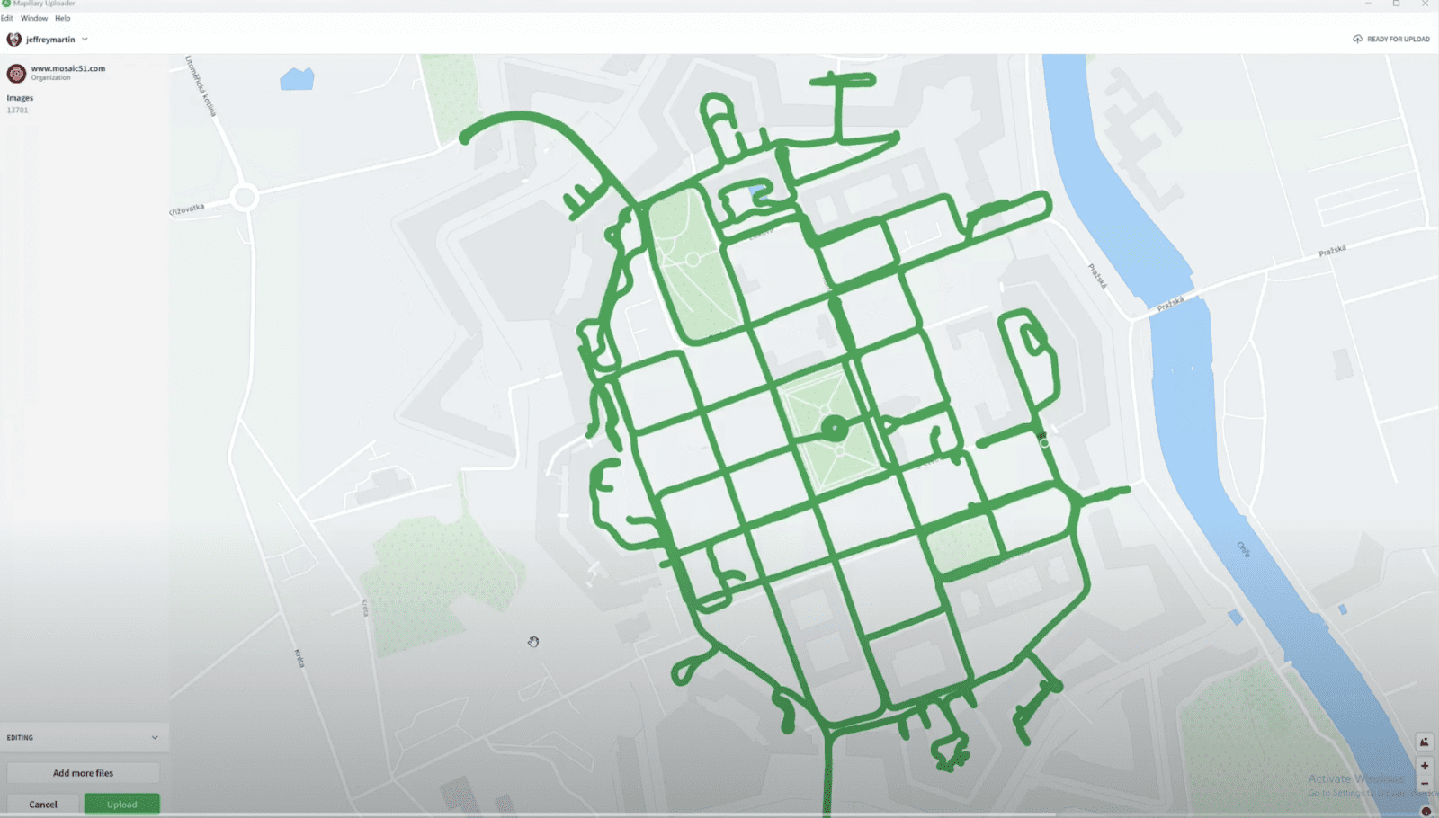
Afterwards, 13,701 images were uploaded to Terezin, Czech Republic.
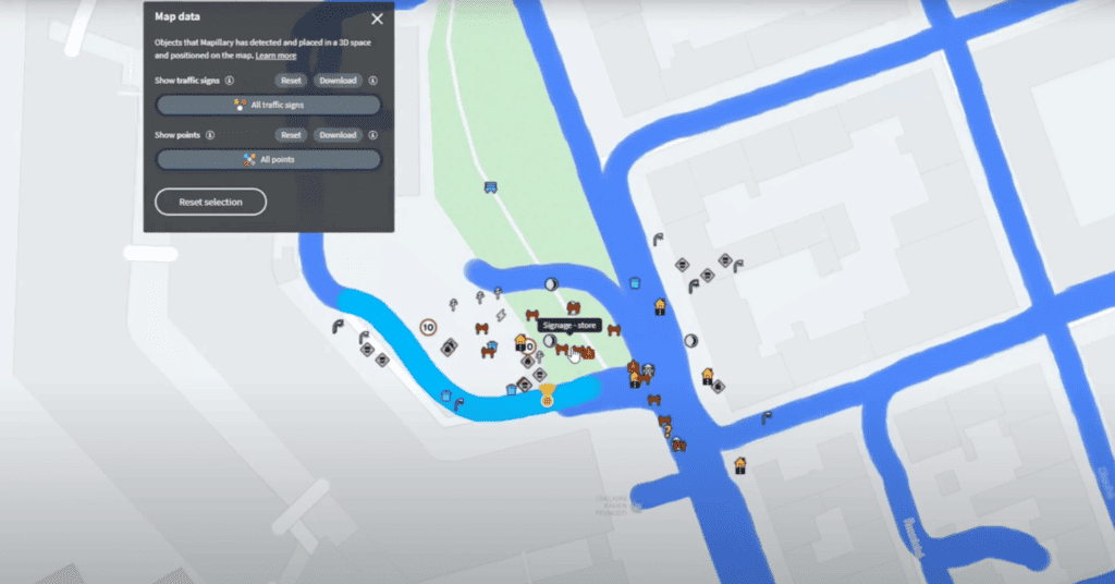
Step 5: Extract features within Mapillary
Step 6: Integrate Data into ArcGIS
Then, data from Mapillary can be integrated into ArcGIS Pro and Web App Builder. Users can find out more information here. Detailed documentation on how to set it up can be found here.
Stay tuned for our next article, where we show you what you can do with 360º street view imagery in ArcGIS Pro and ArcGIS Web App Builder.
For the whole step-by-step process seen above, check out this video to see it all as it happens.
Interested in learning more about Mosaic cameras?
Now that you’ve seen the process, learn more about Mapillary and Mosaic! Use these two technologies, which undeniably form an impressive partnership for those in road and street asset management, utility and telecom surveying, and engineering project management.
Enhancing Geospatial Insights with Mosaic Mobile Mapping and Mapillary’s Seamless Workflow
Modern mapping needs real-time data for both effective asset management and urban planning. This is crucial for both public and private sectors involved in road, network, or utility management. However, data collection and analysis have been challenging.
Mapillary aims to solve this, chiefly, by refreshing map data using street-level imagery. They’ve expanded by adding 42 new objects as point features extractable from imagery, enhancing map detail. Initially focused on traffic sign recognition using advanced tech, Mapillary has grown towards universal traffic sign recognition with global contributions.
The integration of Mosaic’s Mobile Mapping Camera Systems with Mapillary is set to advance geospatial data collection and analysis during this transitional time in technology. Mosaic’s systems ensure precise data capture and processing, all while being affordable and easy to operate. This collaboration simplifies workflows, from data capture to actionable insights, promising significant impact in the geospatial and asset management fields.
The Mosaic Mobile Mapping Camera Systems
In the geospatial domain, the accuracy and granularity of data are as crucial as the efficiency of collection and processing. The Mosaic Mobile Mapping Camera Systems are engineered to excel in all these aspects. They finally provide a robust solution for modern-day mapping challenges.
Features of the Mosaic Camera System
Built-in GNSS, GPU, and CPU
The heart of the Mosaic camera system is its integrated Global Navigation Satellite System (GNSS). It ensures precise geolocation data for each image captured.
Accompanying the GNSS is a high-performance Graphics Processing Unit (GPU) and Central Processing Unit (CPU). They are pivotal in ensuring that the device is a fully standalone unit, thereby eliminating the need for a bulky computer within the vehicle during data capture.
Hot Swappable SSD for Data Storage
Storing the voluminous data is a breeze with the onboard Solid State Drive (SSD) unit. It not only provides ample storage but also ensures quick data retrieval and transfer.
Data Captured by the Camera
The following is the data captured and stored onboard the Mosaic 51 and Mosaic X camera systems. Note that due to the on-board storage, there is no need to use a computer or workstation within the vehicle during data capture. As a result, this eases the process and eliminates points of failure.
- Frames_times.csv
- This file records the timestamps of each captured frame, thus creating a chronological log that is crucial for syncing with geospatial data.
- Route.gpx
- The raw output from the GNSS receiver is stored in this file, usually recorded at a frequency of 10Hz, and then provides a granular view of the geospatial trajectory.
- Route_frame_synced.gpx
- An interpolated and synced version of the geospatial data. This file provides the position of each captured frame along with the time of acquisition, thus ensuring a coherent dataset.
- Six Video Container Files
- Each of the six video container files corresponds to a camera sensor, capturing the surrounding environment in high definition from multiple angles, therefore creating a comprehensive 360º imagery.
The meticulously designed Mosaic Mobile Mapping Camera Systems are not just data collection devices but a comprehensive solution designed to sync effortlessly with Mapillary’s platform. By addressing the needs for high-precision data capture, secure data storage, and an easy-to-use device, these camera systems are geared to propel the geospatial and asset management fields into a new era of efficiency and accuracy.
Seamless Workflow from Data Capture to Mapillary
The combination of Mosaic Mobile Mapping Camera Systems and Mapillary’s platform orchestrates a streamlined workflow that transitions smoothly from data capture to insightful analysis on Mapillary. This synergy alleviates the traditional bottlenecks associated with geospatial data in both handling and analysis.
Data Capture
Ease of Capturing Comprehensive Geospatial Data
With Mosaic camera systems, capturing street-level imagery becomes a straightforward task. The cameras, mounted on vehicles or carried by individuals, record the surroundings in a 360º view. As a result, one can generate a rich dataset that forms the foundation for subsequent analyses.
Importance and Application of the 360º Imagery
Overall, the 360º imagery is pivotal for a myriad of applications ranging from asset management to urban planning. It provides a detailed visual context that enhances the understanding and interpretation of geospatial data.
Processing and Uploading
Mosaic Post-Processing Tool
Each camera produced and delivered by Mosaic also comes accompanied with a unique .grp file (calibration template) which allows users to achieve the highest quality of stitching imaginable. Additionally, our Mosaic Stitching Tool eases the processing of batch stitching and geo-referencing of the thousands of images that many users collect on a daily basis.
Find out more about the quick and easy process of unboxing, mounting, collecting, and processing Mosaic data here →
Effortless Uploading to the Mapillary Platform
Uploading the processed data to Mapillary is designed to be as easy as possible. The structured data, once uploaded, is ready to be both analyzed and integrated with existing maps on the Mapillary platform.
Working with Data on Mapillary
Automatic Extraction of Object Classes and Full Segmentation of Imagery
Mapillary’s sophisticated algorithms automatically identify and extract up to 42 objects as point features from the uploaded imagery. The platform also segments the imagery into various categories of assets, providing a detailed breakdown for more in-depth analysis.
In January 2019, Mapillary broadened its horizon by introducing the capability to identify and position 42 new point features on maps from street-level imagery. This was a significant leap from its initial focus on traffic sign recognition. This advancement came as a boon to cities and mapping entities striving to keep their maps updated. The simplicity of the process is noteworthy; individuals can use basic cameras to capture imagery, which is then analyzed by Mapillary’s sophisticated computer vision technology to identify and map a myriad of objects such as utility poles, streetlights, and manholes.
Initially, Mapillary had honed its algorithms to detect around 1,500 types of traffic signs.

However, with this new addition, the platform’s recognition capabilities extended across diverse categories like pedestrian mobility, cycling, transportation, public works, and road maintenance, significantly enriching the data available for geospatial analysis. Although initially these features were in beta and available through a subscription, the object and traffic sign identification capabilities have since transitioned into the public domain, making them accessible to a broader audience. Mapillary continues its journey with plans to extend traffic sign recognition to more countries and incorporate optical character recognition for textual signs, embodying a relentless pursuit to make geographical data more detailed, current, and universally understandable.
Point Features Detected by Mapillary
Generic map features are represented by points on the map.
- Represent 42 types of objects, like trash cans and manholes, on the map as points.
- Mapillary provides estimated coordinates based on image detections.
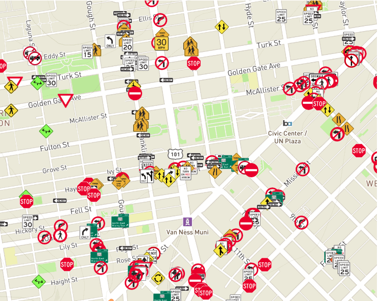
Traffic Signs Detected by Mapillary
Also represented as point features on the map, they are treated distinctly from other point features on Mapillary.
- Categorized into over 1,500 classes from 100 countries.
- Estimated coordinates of traffic signs are provided based on the images in which they are detected.
The following objects can be extracted from Mapillary imagery as point features:
| – Temporary Barrier – Crosswalk – Plain – Driveway – Lane Marking – Arrow (Left) – Lane Marking – Arrow (Right) – Lane Marking – Arrow (Split Left or Straight) – Lane Marking – Arrow (Split Right or Straight) – Lane Marking – Arrow (Straight) – Lane Marking – Crosswalk – Lane Marking – Give Way (Row) – Lane Marking – Give Way (Single) – Lane Marking – Other – Lane Marking – Stop Line – Lane Marking – Symbol (Bicycle) – Lane Marking – Text – Banner – Bench – Bike Rack – Catch Basin – CCTV Camera – Fire Hydrant | – Junction Box – Mailbox – Manhole – Parking Meter – Phone Booth – Signage – Advertisement – Signage – Information – Signage – Store – Street Light – Pole – Traffic Sign Frame – Utility Pole – Traffic Cone – Traffic Light – Cyclists – Traffic Light – General (Horizontal) – Traffic Light – General (Single) – Traffic Light – General (Upright) – Traffic Light – Other – Traffic Light – Pedestrians – Trash Can – Water Valve |
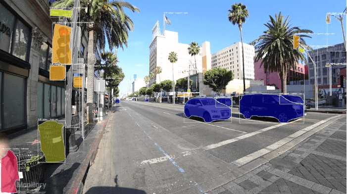
Object Detection by Mapillary
Mapillary’s computer vision technology utilizes a method known as semantic segmentation to autonomously identify various objects depicted in images, such as buildings, cars, pedestrians, and bicycle racks. Each image is then tagged with geocoordinates, enabling the visualization of object detections on a map. This feature allows for filtering images based on the presence of specific objects. The map at this juncture reflects the positions of images where certain objects are visible, aiding in the identification and categorization of objects found within the images.
Though the map visualizations represent where certain objects are detected, it’s a step away from map features, which take it further by triangulating the real-world location of an object detected in several images, determining its actual location, and placing it on the map as a map feature. To access and utilize these automatically extracted object detections, one needs to query map data using the Mapillary API. These capabilities are available for exploration on the Mapillary web app, making it a powerful tool for geospatial analysis and urban planning endeavors.
Below is the list of 65 object classes detected by Mapillary (in addition to traffic signs and point features):
| Curb Fence Guard rail Barrier (other) Lane separator Wall Bike lane Crosswalk (basic) Curb cut Parking Pedestrian area Rail track Road Road shoulder Service lane Sidewalk Traffic island Bridge Building Garage Tunnel Person | Lane marking (dashed) Lane marking (solid) Crosswalk (zebra) Lane marking (other) Lane marking (stop line) Lane marking (text) Sky Snow Lawn Vegetation Water Banner Bench Bike rack Billboard Catch basin Fire hydrant Junction box Mailbox Manhole Parking meter Pothole | Streetlight Pole (generic) Traffic sign frame Utility pole Traffic cone Traffic light Traffic sign Construction sign Trash can Bicycle Boat Bus Car Caravan Motorcycle Train Vehicle (other) Trailer Truck Wheeled slow vehicle Wire group |
Deriving Geographical Insights for Asset Management and Maintenance
The categorized and segmented data on Mapillary opens a vista of analytical possibilities. Professionals can delve into the data to identify, locate, and analyze assets, facilitating informed decision-making for asset management, maintenance, and other geospatial endeavors.
Accessible and Free Processing Within Mapillary
The publishing capabilities within Mapillary are not only robust but also free and accessible to anyone, anytime. This democratization of geospatial data processing is a significant stride towards fostering a collaborative environment for geospatial professionals across various sectors.
The seamless workflow orchestrated by the integration of Mosaic Mobile Mapping Camera Systems and Mapillary’s platform is a testament to the advancements in geospatial technology. By simplifying and accelerating the journey from data capture to geospatial insights, this integration is poised to be a cornerstone for modern asset management and urban planning initiatives.
Benefits and Applications
The fusion of Mosaic Mobile Mapping Camera Systems and Mapillary’s platform is more than a technical integration; it’s an enabler of enhanced geospatial analysis and collaborative urban development efforts. The benefits and applications stemming from this integration are vast and transformative.
Enhancing Asset and Road Network Management with Detailed, Up-to-Date Maps
Asset Identification and Monitoring
With the ability to capture and analyze street-level imagery, asset managers can then identify, monitor, and manage urban assets with a higher degree of accuracy and efficiency.
Road Network Analysis
The current maps generated enable a more in-depth analysis of road networks and aid in maintenance planning, traffic management, and infrastructure development.
Real-Time Updates
The seamless workflow enables real-time updates to the maps, ensuring that the data reflects the most current state of urban environments. This is a critical feature not only for emergency response, but also for general urban planning.
Collaborative Efforts Between Public and Private Sectors in Utilizing Geospatial Data
Data Sharing and Analysis
The platform promotes data sharing and collaborative analysis between public and private sectors, fostering a community-driven approach to urban development and management.
Enhanced Decision-Making
By providing a common platform for geospatial data analysis, decisions regarding urban development and asset management are better informed and more inclusive.
Conclusion
To conclude, the journey from capturing raw geospatial data to gaining useful insights has traditionally been filled with complex processes. Yet, the combination of Mosaic Mobile Mapping Camera Systems and Mapillary’s platform has made this journey much easier and more effective. As a result, this partnership greatly simplifies the geospatial data analysis workflow, benefiting professionals in asset management and urban planning.
With Mosaic’s advanced data capture tech and Mapillary’s strong analytical platform, the geospatial community now has a powerful tool for even faster data processing. In the same way, gain valuable insights from detailed, current maps. This integration creates a seamless workflow by reducing the barriers to thorough geospatial analysis. Imagine fostering a collaborative, informed approach to urban development.
Furthermore, Mapillary’s open-access platform makes this advanced geospatial analysis available to everyone. Whether you’re a public sector organization or a private company serving local and state areas. This broad access to geospatial data processing encourages a more shared and informed approach to asset management, road network analysis, and urban planning.
As we move into an era where data-driven decisions are crucial for smart and efficient urban development, the blend of Mosaic and Mapillary technologies stands out as a key element. It not only pushes the geospatial and asset management fields into a new era of efficiency and teamwork but also sets a hopeful path for urban development’s future.
Now, geospatial professionals are invited to delve into this strong integration, use the smooth workflow, and join the ongoing effort to make our urban areas easier to navigate, manageable, and sustainable.
Join us
Looking to enhance your workflow from data capture to visualization and object detection and classification?
If you’re ready to start the process with high-resolution imagery from a user-friendly, industrial-grade mobile mapping camera built for the job, contact us today!
Let’s see how you can start collecting the highest quality street view imagery at scale as soon as possible.


