
How Texas A&M is Pioneering Damage Assessment Using Mosaic Imagery from Hurricane Milton
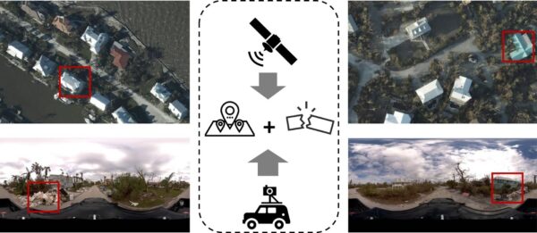
Researchers at Texas A&M are using Mosaic-captured imagery to develop disaster resilience frameworks that bridge the gap between satellite data and ground
Researchers at Texas A&M are using Mosaic-captured imagery to develop disaster resilience frameworks that bridge the gap between satellite data and ground

Developing countries have unique cadastral mapping challenges that 360° street-view imagery can mitigate. Today, we head to Morocco to see how the

How PLACE and Mosaic are reshaping cadastre, tax systems, and climate resilience across five countries

Watch the Mosaic Xplor conduct fast, accurate 3D scans of difficult-to-reach environments.

When UCLA and the University of Hawaii’s research programs need high-resolution 360° imagery of wildfire aftermath, they turn to Mosaic cameras.
There are some scenes only street-view imagery can capture. These researchers are using Mosaic imagery from Hurricane Ian to train GeoAI models


