
IMUs, GNSS, and SLAM technology are important for mobile mapping. Find out how they differ and where they each excel.
This article was updated in 2025 to include the Meridian and Meridian Lite.
What are the differences between IMU, GNSS, and SLAM?
IMU (Inertial Measurement Unit), GNSS (Global Navigation Satellite System), and SLAM (Simultaneous Localization and Mapping) are all navigation and mapping technologies. However, they have different purposes and functions.
IMUs are sensors that measure acceleration and angular velocity in order to determine the orientation and movement of a device. They use a combination of accelerometers, gyroscopes, and sometimes magnetometers to determine their orientation relative to the Earth.
GNSS, on the other hand, determines the location, velocity, and time of a receiver on the Earth’s surface with satellites. The most well-known GNSS system is the Global Positioning System (GPS), which is operated by the United States government.
SLAM, meanwhile, is a technology used to create maps of unknown environments in real-time. It perceives the environment with sensors such as cameras, lidars, and IMUs. Then, it determines the location of a device within it.
In summary, IMUs provide information about the orientation and movement of a device, GNSS provides information about the location of a device, and SLAM uses both IMU and GNSS information to create maps of unknown environments. Each technology has its own strengths and limitations. They can be used in combination to improve the accuracy and reliability of navigation and mapping systems.
When is it best to use IMU over GNSS or SLAM?
The choice between using an IMU, GNSS, or SLAM depends on the specific needs and requirements of the application. Here are some scenarios where using an IMU might be more beneficial:
- Indoor or Enclosed Environments: GNSS signals can be disrupted or lost in indoor or enclosed environments, making IMUs a more reliable option for determining orientation and movement in these environments.
- Dynamic Environments: IMUs are often used in applications where the device is moving quickly or experiencing rapid changes in orientation, such as in robotics, drone navigation, or sports equipment. IMUs provide real-time information about orientation and movement, allowing the device to respond quickly to changes in the environment.
- High-Precision Orientation: For applications that require high-precision orientation information, IMUs can be a better option than GNSS. IMUs provide information about orientation and movement in real-time and can be combined with other technologies, such as Kalman filters, to improve their accuracy.
When is it best to use GNSS over IMU or SLAM?
Here are some scenarios where using a GNSS might be more beneficial than using an IMU or SLAM:
- Outdoor Environments: GNSS signals can be received in outdoor environments. GNSS is a reliable option for determining location, velocity, and time. It can provide location information with high accuracy, especially when multiple satellites are in view.
- Location-Based Services: GNSS is often used in applications that require location information, such as navigation systems, geolocation services, and mapping. GNSS provides real-time information about the location of a device, allowing these applications to function accurately.
- Large-Scale Mapping: For applications that require large-scale mapping, GNSS can provide a global reference frame. Now, maps can cover large areas with high accuracy.
When is it best to use SLAM over IMU or GNSS?
Here are some scenarios where using SLAM might be more beneficial than using an IMU or GNSS:
- Unknown Environments: SLAM helps create maps of unknown environments in real-time. It is a valuable tool for robotics, autonomous systems, and other applications that operate in changing or unpredictable environments.
- Dynamic Environments: SLAM can help track movement and orientation in real-time. This is a good option for applications that require high-precision information about movement in dynamic environments. That can include drones, robots, and augmented reality applications.
- Resource-Constrained Environments: SLAM can help generate maps and track movement without the need for external sensors or infrastructure. It is a good option for resource-constrained environments where GNSS signals may be limited or unavailable.
Let’s break it down more and see what each of these is, and some of the companies behind these sensors.
Details: What is an IMU?
IMUs, or Inertial Measurement Units, are devices that measure and provide information on a body’s specific force, angular rate, and sometimes the magnetic field surrounding the body. They typically consist of a combination of accelerometers, gyroscopes, and sometimes magnetometers.
How, where, and why are IMUs used?
IMUs have a wide range of applications. They are in basic navigation and orientation to more advanced applications such as robotics, drone navigation, and autonomous vehicles.

Here are some examples of where IMUs are used:
- Smartphones: IMUs in smartphones provide motion tracking, orientation, and stability control.
- Drones: IMUs in drones provide precise control and stability during flight.
- Robotics: IMUs in robots provide real-time information about movement and orientation. They enable robots to navigate and perform tasks autonomously.
- Virtual Reality (VR) and Augmented Reality (AR) Head-Mounted Displays (HMDs): In VR and AR HMDs, IMUs track head and body movement. They enable users to interact with virtual environments in real-time.
- Wearables: IMUs in wearables track and monitor physical activity, including steps taken, calories burned, and sleep patterns.
- Automotive Systems: IMUs are in some advanced driver assistance systems (ADAS) in cars. They provide stability control and driver assistance.
- Industrial Equipment: IMUs are in industrial equipment such as cranes, excavators, and heavy machinery. They provide precise control and stability during operation.
- Mobile mapping units: They are also common in mobile mapping and surveying. They can provide precise and accurate location, orientation, and movement information.
What advantages can an IMU give the user?
One of the main advantages of using IMUs in mobile mapping is that they can provide accurate location and orientation information even in environments where GPS signals may be weak or unavailable. This is because IMUs rely on internal sensors rather than external signals to determine a device’s location and orientation. Additionally, IMUs can improve the accuracy and precision of data collected during mobile mapping surveys. This is because they can provide real-time corrections for errors caused by factors such as device tilt or movement.

What types of IMUs are there?
There are many different types and models of IMUs available on the market. They have varying levels of precision, accuracy, and features. Some basic IMUs may only provide basic information such as orientation and acceleration. However, more advanced IMUs may include features such as multi-axis measurement, temperature compensation, and built-in data logging.
In mobile mapping, there are many companies that specialize in providing IMU solutions, such as Applanix, NovAtel, and Trimble. These companies offer a range of IMU solutions for different applications and budgets. It’s worth comparing their products and features to determine which IMU solution would best suit your specific needs.
What are the key features of an IMU?
There are several key features that can make an IMU “good” or above average. Some of these include:
Precision and accuracy:
The precision and accuracy of an IMU’s measurements are one of the most important factors to consider. High-precision and accurate IMUs can provide more reliable and accurate data. This is critical for applications such as mobile mapping and navigation.
Multi-axis measurement:
An IMU with multi-axis measurement capabilities can provide information on multiple degrees of freedom, such as roll, pitch, and yaw. This can be useful for applications that require detailed information on the orientation of a device.
Temperature compensation:
Some IMUs include temperature compensation capabilities. They can help to ensure that measurements remain accurate over a wide range of temperatures.
Data logging:
Some IMUs include built-in data logging capabilities, which can be useful for recording measurements over an extended period of time.
Interfaces:
Different IMUs offer different interfaces to connect with other devices or systems, such as UART, I2C, USB, Ethernet, and so on. The availability of the interfaces will depend on the application that you have.
Robustness:
Some IMUs can withstand harsh environmental conditions, such as high vibrations, extreme temperatures, and humidity. This can be important for applications such as robotics and autonomous vehicles, where the IMU may be subject to harsh conditions.
Size and power consumption:
Some IMUs are compact and lightweight, which can be useful for applications such as drones and wearable devices. Additionally, the power consumption of an IMU can also be an important factor to consider, particularly for applications that require long battery life.
Brand reputation and support:
Finally, the reputation of the IMU’s brand and its support can also play a role in determining the quality of the IMU. Brands with a good reputation and strong support network may be more likely to provide reliable and long-lasting IMU solutions.
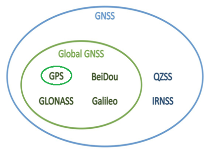
Details: What is a GNSS?
GNSS, or Global Navigation Satellite System, devices are navigation systems that use satellites to determine the location, velocity, and time of a receiver on the Earth’s surface. The most well-known GNSS system is the Global Positioning System (GPS), which the United States government operates.
How, where, and why are GNSS used?
GNSS devices are used in a wide range of applications, from basic navigation and location-based services to more advanced applications such as surveying, mapping, and autonomous vehicles. They can also be used in combination with other technologies, such as Inertial Measurement Units (IMUs), to improve their accuracy and reliability.
In mobile mapping, GNSS devices are used to determine the precise location and orientation of a mapping device as it moves through an environment. This information helps create accurate maps and survey data. It can also help correct for errors caused by factors such as device tilt or movement.
GNSS (Global Navigation Satellite System) and GPS (Global Positioning System) are widely used in a variety of devices and applications. Here are some examples:
- Personal Navigation Devices: Handheld GPS units, smartphone navigation apps, and wearable GPS devices use GNSS/GPS for navigation and location tracking.
- Automotive Navigation: Many modern vehicles have built-in GNSS/GPS navigation systems, providing drivers with turn-by-turn directions and real-time traffic updates.
- Geographical Information Systems: GNSS/GPS is used in GIS (Geographical Information Systems) to collect, manage, and analyze geographic data, such as topographical maps, land use patterns, and environmental data.
- Surveying and Mapping: GNSS/GPS is important in surveying and mapping to determine precise location and elevation information, such as in the construction of roads, buildings, and infrastructure.
- Agriculture: GNSS/GPS is useful in agriculture for precise planting, harvesting, and soil analysis, as well as for monitoring livestock and wildlife.
- Drones: GNSS/GPS is used in drones for navigation, location tracking, and precise mapping of large areas.
- Search and Rescue: GNSS/GPS helps in search and rescue operations to locate individuals and track their movements in real-time.
What advantages can a GNSS give the user?
One of the main advantages of using GNSS devices in mobile mapping is their ability to provide precise location information on a global scale. Additionally, GNSS devices can help improve the speed and efficiency of mobile mapping surveys, as they can provide real-time location information without the need for additional equipment or manual measurements.
What types of GNSS are there?
There are many different types and models of GNSS devices available on the market, with varying levels of precision, accuracy, and features. Some basic GNSS devices may only support GPS, while more advanced GNSS devices may support multiple GNSS systems, such as GLONASS, Galileo, and BeiDou, which can improve the accuracy and reliability of location information.
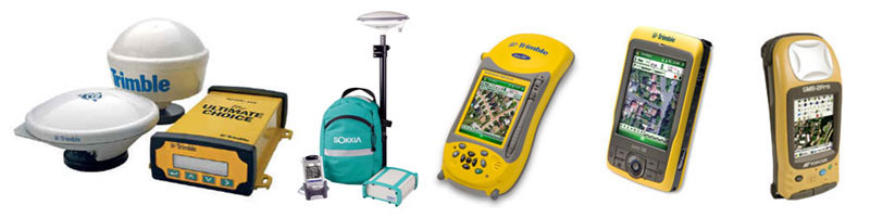
In mobile mapping, there are many companies that specialize in providing GNSS solutions, such as Trimble, Leica Geosystems, Carlton, and Topcon. These companies offer a range of GNSS solutions for different applications and budgets, and it’s worth comparing their products and features to determine which GNSS solution would best suit your specific needs.
What are the key features of a GNSS?
Here are some key features to look for when evaluating the quality of a GNSS (Global Navigation Satellite System) device:
- Multi-Constellation Support: A high-quality GNSS device should support multiple satellite constellations, such as GPS, GLONASS, Galileo, and BeiDou, to ensure the most accurate and reliable positioning information.
- High Update Rate: A high-quality GNSS device should have a high update rate, providing frequent and accurate location updates. This is especially important for applications that require real-time or near-real-time positioning information, such as autonomous vehicles or robotics.
- Wide Area Augmentation System (WAAS) Support: A GNSS device that supports WAAS improves the accuracy of positioning information in areas with limited or obstructed GPS signals.
- RTK Capability: Real-Time Kinematic (RTK) GNSS devices provide centimeter-level accuracy, making them a good choice for applications that require high-precision location information, such as surveying, mapping, and construction.
- Low Power Consumption: For applications that require long battery life, a GNSS device with low power consumption is important.
- Robust Design: A high-quality GNSS device should be robust and reliable, with features such as a rugged design and resistance to water, dust, and shock.
- Easy to Use: A GNSS device that is easy to use and has a user-friendly interface is important for applications where time is of the essence.
- Cost: High-quality GNSS devices can range in cost, with more advanced features typically resulting in a higher price point. It’s important to evaluate the specific needs and requirements of an application and choose a GNSS device that offers the best combination of features and cost.
*Other alternatives to GPS: VPS and CPS.
Details: What is SLAM?
SLAM, or Simultaneous Localization and Mapping, is a technology used to create maps of unknown environments in real-time. It uses sensors such as cameras, lidars, and IMUs (Inertial Measurement Units) to perceive the environment and determine the location of a device within it.
How, where, and why is SLAM used?
SLAM is used in a wide range of applications, from augmented reality and robotics to autonomous vehicles and mobile mapping. It can also be used in combination with other technologies, such as GNSS (Global Navigation Satellite System), to improve its accuracy and reliability.
In mobile mapping, SLAM is used to create maps of environments as a mapping device moves through them. It can help to improve the speed and efficiency of mobile mapping surveys, as it can create accurate maps without the need for additional equipment or manual measurements.
Simultaneous Localization and Mapping (SLAM) technology is used in a variety of devices and applications that require real-time mapping and localization. Here are some examples:
- Mobile Robots: SLAM technology is widely used in mobile robots for navigation, mapping, and exploration of unknown environments.
- Autonomous Cars: SLAM technology is useful in autonomous cars for real-time mapping and navigation, enabling the vehicle to make accurate and safe decisions.
- Augmented Reality: SLAM technology exists in augmented reality devices, such as smart glasses, to create and maintain accurate maps of the surrounding environment.
- Drones: SLAM technology exists in drones for navigation, mapping, and exploration of unknown environments, such as disaster zones or remote areas.
- Virtual Reality: SLAM technology is used in virtual reality devices, such as VR headsets, to enable the user to move around and interact with a virtual environment in real-time.
- Robotics: SLAM technology is used in robotics for navigation, mapping, and exploration of unknown environments, as well as for real-time object recognition and manipulation.
- Smart Home: SLAM technology exists in smart home devices, including vacuum cleaners and security cameras, to create and maintain precise maps of the surrounding environment.
What advantages can SLAM give the user?
One of the main advantages of using SLAM in mobile mapping is its ability to create maps in real-time. This can be useful for applications such as emergency response, where maps of unknown environments may be needed quickly. Additionally, SLAM can also help to improve the accuracy and reliability of mobile mapping surveys, as it can correct for errors caused by factors such as device tilt or movement.
What types of SLAM technology are there?
There are many different types and models of SLAM technology available on the market, with varying levels of precision, accuracy, and features. Some basic SLAM systems may only use a single sensor, such as a camera, while more advanced SLAM systems may use multiple sensors, such as lidars and IMUs, to improve their accuracy and reliability.
In mobile mapping, there are many companies that specialize in providing SLAM solutions, such as Huawei, Google, and Microsoft. These companies offer a range of SLAM solutions for different applications and budgets, and it’s worth comparing their products and features to determine which SLAM solution would best suit your specific needs.
What are the key features of a SLAM device?
Here are some key features to look for when evaluating the quality of a SLAM (Simultaneous Localization and Mapping) device:
- Accuracy: A high-quality SLAM device should provide accurate and reliable location and mapping information. This is especially important in applications that require real-time or near-real-time information.
- Scalability: It is important that a SLAM device can handle a wide range of environments and scales. For example, from small indoor spaces to large outdoor areas.
- Speed: A high-quality SLAM device should be able to generate maps and localize quickly, with low latency.
- Robustness: A SLAM device that can handle environmental factors such as changing lighting conditions, dynamic objects, and partial occlusions is important.
- Sensors: A high-quality SLAM device should use multiple sensors, such as cameras, LiDAR, and IMUs, to provide the best possible information for mapping and localization.
- Flexibility: A SLAM device that can be easily integrated into a wide range of applications and systems is important.
- Power Consumption: For applications where battery life is a concern, a SLAM device with low power consumption is important.
- Cost: SLAM devices can range in cost, with more advanced features typically resulting in a higher price point. It’s important to evaluate the specific needs and requirements of an application and choose a SLAM device that offers the best combination of features and cost.
Mosaic Meridian as a solution
If you are looking for a mobile mapping camera solution that already includes or can integrate with any of the above devices, then you’re in the right place. Mosaic cameras come with a built-in GPS, allowing users to capture image data and geo-referenced points all at the same time and on one device.
Our Meridian is a mobile mapping system that integrates the Mosaic X with a LiDAR system and GNSS receiver. This groundbreaking solution meets the needs of surveying, mapping, and GIS professionals who demand high-quality imagery and reliable LiDAR data.
The Meridian Lite is our more budget-friendly package. It features a Mosaic 51 camera and is ideal for urban environment data capture. The rolling shutter design captures the imagery you need today without overdoing it and clogging up the post-processing. Capture today and deliver results tomorrow!
Already have your own LiDAR unit? No worries! Mosaic cameras are also able to easily integrate with additional sensors, such as external GNSS, IMUs, wheel encoders, and LiDAR. So you can mix and match with the sensors that will give you the best data for your use case.
Find out more about our cameras here.
And when you’re ready to reach out, contact us here.


