
What is an alternative to GPS? With the advent of cameras, is the ubiquitous yet unreliable/inaccurate GPS on its way out?
Is there an Alternative to GPS ?
Yes, there is an alternative to GPS that is rising in fame, favorability, and calibre. It has been coined, VPS – ‘Visual Positioning System’ or CPS – ‘camera positioning standard’ by some. Rather than relying on geospatial referenced data, it works with images or visual data.
When we consider how humans see, think and interact with our environments, then we can see the introduction of these technologies as the way in which we and our technologies are becoming more and more similar.
For some, that is sure to scare them. But others are taking the bull by the horns and finding innovative ways to adapt VPS and CPS for their industry’s challenges.
This is Part 2 in a series about GPS accuracy and where we go from here. In Part 1, we discussed just how accurate (or inaccurate) GPS can be. If you haven’t checked that out yet, it might help to understand why the most common form of GNSS is not the most accurate and how that can affect a lot of leading industries.
Or if you prefer the synopsis, have a look below for a short summary:
Why do we need something besides GPS?
As an abridged version of the previous article in this series:
- GPS or Global Positioning System was developed by the United States Department of Defense in the 1970’s. It became available to the general public in the 1980’s and President Clinton signed into law legislation ensuring that the GPS accuracy would never be degraded for the general public.
- GPS Accuracy: GPS is fairly accurate for your everyday user. If you are driving from point A to point B, chances are you can get there fairly safely. Although occasionally there are some mishaps on the road.
- GPS Inaccuracies: these are caused by the positioning of the satellites, interference with large structures or landmarks (e.g. buildings, mountains), indoors and underground
- Industries where it matters: Our future roads and cities will depend heavily on extremely accurate and precise maps, directions, and representations of our world. The self-driving car industry, governments working to make smart cities, real estate and insurance companies, and utility companies, all depend on having better positioning data than GPS currently provides.
So what can we use instead of GPS?
In 2010 a group of researchers presented a paper entitled, ‘Indoor positioning within a single camera and 3D maps.’ In it, they outline their proposal for a method involving vision-based positioning through the use of a single camera and 3D maps. The (then new) technology sought to address the accuracy and reliability of indoor navigation systems. They referred to the technology as ‘indoor location-based position system’, visual positioning technology, or vision-based positioning.
The main benefit as they saw it was to improve the positioning accuracy via the use of photogrammetric 6DoF (degrees of freedom) pose estimation method, allowing for higher accuracy in cities, as well as indoors and underground.

Fast forward a decade and their research has proven to be on the right track. There are an array of companies working on creating an alternative to GPS, mainly VPS and CPS technologies, for higher positioning navigation and positioning, both indoors and out.
What are VPS and CPS?
Single-image positioning service, powered by computer vision.
Scrape Tech founder Edward Miller
Visual Positioning Systems and Camera Positioning Standard are technologies which rely on images rather than geographical coordinates. Through a single image, the technology can determine the position and orientation along 3 axes, from the point of image capture.
It also allows the images taken from a mobile phone or scanned with a robot’s camera sensors to interact with the surroundings.
This means that the average human being with a smartphone can snap a few photos from within a mapping platform (such as Google Maps), and can learn about his or her environment with higher accuracy than GPS, such as the nearby shops and businesses. Or gain the confidence that they are really going in the right direction through visual clues.
Or if it is a robot taking the photos, the robot’s sensors will gather the imagery data and utilize that to steer itself around corners, across bumpy roads, and around warehouse shelving units.
What you need for VPS and CPS
- Camera
- IMU – for ‘on-the-fly’ map creation
- Additional sensors (GPS, odometry, laser) can enhance but are not necessary
- Highly precise 3D and 360 machine-readable map of visually distinct features
- This can be created with 2D images, RGB-D images, or a 3D point cloud
- This can be created with 2D images, RGB-D images, or a 3D point cloud
How VPS and CPS Work
- Create the initial reference map of the space, warehouse, city using 100% pure images to create a 3D model
- Store this map on a local server or a cloud network
- User (or robot) takes a photo that can be interpolated with the reference map
- Software extracts the local features from the image and compares it to the 3D representation, accessible through the server or cloud
- Software identifies features from the sent image to that in the 3D model
- Precisely identifies the location of the device or point where the image was taken
Benefits and Uses of VPS and CPS
Humans are visual people and we also want our technologies to see like us. With a visual method of interacting with our environments, we are allowing software and hardware to work with us in a way that is more understandable and comprehensible to us. There are a good deal of advantages to these over GPS, which we have listed below. And the uses are varying and extensive. See the full list below.
Advantages to using an alternative to GPS
- Centimeter level accuracy
- 3D position and orientation
- Fewer devices
- Works in dense urban environments where buildings can block signals
- Accessible indoors
- Improves the lives of the visually impaired
- Stays up to date in changing environments
- Allows for absolute positioning (not relative positioning which GPS gives)
- Possibility for ‘on-the-fly’ reference map creation
- Much cheaper than LiDAR
Uses of VPS or CPS
Less than 10 years later and we are already seeing the uses of the vision-based positioning
- Robotics:
- Safely navigate a robot
- Self navigation by robots
- Obstacle detection and avoidance
- Large indoors spaces (airports, supermarkets, or warehouses):
- Scan a room in 3D and create a floor plan
- Track and trace the position and orientation of assets
- Inventory location and counting
- Auto:
- Always know where your car is
- Localization for autonomous vehicles
- Offer clearer, safer information for rideshare users
- Mobile and Gaming:
- Position tracking for augmented reality and VR
- Create interactive multiplayer AR experiences
- Players can share the same experience and collaborate
- Augmented Marketing:
- AR menus ‘floating’ in space next to restaurants
- Product information and reviews above items on a shelf
- Interactive visitor guides
- Mobility:
- Tracking the path of a scooter to ensure it is traveling down the correct lane
- Positioning of small vehicles like bikes and scooters in the correct parking zones
- With an overly for real time position (such as in Google Maps or Street View), a pedestrian to see their actual surroundings while navigating busy streets
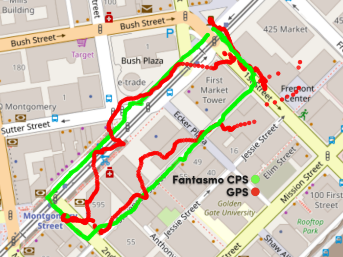
Here’s an example of how Fantasmo paired with TIER, a scooter sharing service in Paris to ensure that users are parking their scooters in designated areas:
Who is leading the way in VPS?
- Google: of course the leader in almost everything, Google introduced a new way to navigate with an overlap inside their mapping apps
- Fantasmo: this was the first company to coin the particular term CPS and they are dedicated to bringing safer usage of scooters and other micro-mobility vehicles.
- Intermodialics: they focus on industrial level solutions, mainly for warehouses and large indoor spaces
- Daedalean: a UAV and autonomous piloting system for aircraft which provides services in positioning, traffic detection and landing guidance
What’s next
As always, Mosaic is extremely interested in the latest technology and the possibilities they bring to us – and we mean humankind, not just Mosaic 😉
We do believe that VPS and CPS can offer an alternative to GPS, thereby providing a more attainable way of mapping the world for companies large and small, as well as more accuracy in industries where it matters.
And we do believe that, as leaders in the field of 360 mobile mapping cameras and data collection, we can be a part of the process of creating the HD maps which are the necessary backbone of these technologies.
So if you are in need of such services, be sure to reach out to us to learn more about the most robust and high resolution 360º mobile mapping cameras and mobile mapping data collection in the world.


