
What’s the best technique for creating a point cloud? Let’s face off lidar vs photogrammetry and find out.
What is a point cloud?
A point cloud is a set of points in space that represent the surface of an object, which has many purposes. The points are typically created by a 3D scanning method, such as LiDAR or photogrammetry, which measures the distance between the scanner and nearby objects. These two methods measure the objects in question with different tools – LiDAR uses lasers, while photogrammetry uses photographs.
Point clouds are also often used to create high-quality maps of city environments or to provide accurate topographical information about natural terrain. This data type is also often the foundation for creating digital versions of real-world objects, of all sizes.
When or how do you use a point cloud?
Before we get into how these two methods – LiDAR and photogrammetry both separately create point clouds, let’s look at a few industries and use cases for point cloud creation.
Some industries that rely on point clouds are civil and environmental engineering, mapping, geology, GIS, architecture, archeology, military, and public safety.
Just to give a few examples of how each of these industries might use a point cloud specifically for their needs, let’s have a look.
Use cases for point clouds:
- Land surveying: point clouds can help surveyors create a digital representation of a stretch of land, which holds all of the key elements – infrastructure, natural formations, roads, real estate, and more
- Environmental monitoring: point clouds can help scientists and environmentalists detect changes in a piece of land over time by comparing point clouds of an eroding beach or glacier
- Structural inspections: insurance and real estate companies can review the deterioration of a building through the months or years, always keeping a digital copy on hand for comparison
- Historical site surveying: historians and archeologists can collect data and create digital copies of delicate ruins with remote data capture via LiDAR or photogrammetry, so as not to disrupt the site
How can you create a point cloud?
As we stressed earlier, there are two types of technologies that can be used to create point clouds. LiDAR uses lasers in order to measure distances from the sensor to objects in the environment. Photogrammetry, on the other hand, uses photographs taken from various angles of an object in order to calculate its dimensions and generate a 3D model by using triangulation.
Both technologies have their strengths and weaknesses, their pluses and minuses. It has a good deal to do with your budget and with the size of the area or object that you are attempting to make a point cloud of.
Let’s get into which option might be the better option for you and your use case. Allow us to walk you through understanding where each one shines and where it ‘fails’.
What is LiDAR and how does it work?
LiDAR stands for Light Detection and Ranging, or one of several other definitions. It is also written several different ways, so don’t concern yourself too much with that. It’s a technology that uses lasers in order to measure distances from the sensor on the LiDAR device to objects in the environment. LiDAR is a geomatics method that measures distance to the object – whether it be the Earth’s surface or an apartment building – using laser light in the form of a narrow pulsed beam emitted from a single laser source. It can be contrasted with radar, which uses radio waves instead of lasers, or reflector-less laser scanning, which does not use pulsing.
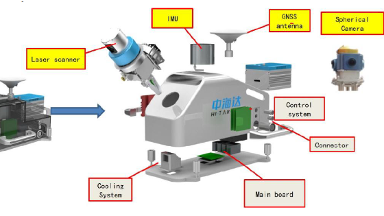
A laser scanner combines a laser rangefinder with rotating mirrors and an inertial measurement unit. The earliest affordable consumer LiDARs first appeared in the early 2000s. These devices can be found on a whole host of vehicles. They are sometimes found spinning on top of high-end commercial UAV (unmanned aerial vehicle) platforms employed by filmmakers for aerial survey work. Or they are part of a mobile mapping system (MMS), placed atop a car, van, or truck.
The high-level goal of LiDAR remote sensing is to measure the distance from the sensor plane to points on an object’s surface at regular time intervals and relate these measurements back to their coordinates in space and time. These measurements may be used as input into higher-level algorithms and applications, such as feature extraction, change detection, classification, or image modeling.
What are some uses of LiDAR?
Like we said earlier, LiDAR is used for some sort of survey. Whether it be for a private construction company, a municipality, or a team of researchers.
LiDAR is used in a great deal of industries, such as:
- Geology
- Archeology
- Manufacturing
- Construction
- Survey
- Mining
- Car manufacturing (particularly in the autonomous vehicle division)
- Law enforcement
- Archeology
- Geology
LiDAR can be used to scan and create 3D models of:
- The surface of the Earth
- Buildings and other man-made structures
- Trees and other plants
- Rivers, lakes, and other bodies of water
- Volcanoes
- Rock formations
Within those fields, LiDAR technology can be used in a number of applications, including:
- remote sensing
- terrestrial laser scanning (TLS)
- road profiling
- topography and geodesy (e.g., land surveying and land use mapping)
- forestry and wildlife conservation
- biodiversity assessment and management
LiDAR is often used in autonomous driving, so it’s important for these vehicles to be able to map their surroundings in order to avoid collisions.
In order to create a point cloud with LiDAR, you need the following tools and software:
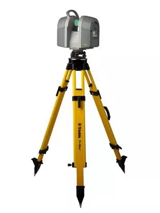
- LiDAR scanner/sensor – this is generally a single, stand-alone tool, used for stationary purposes, so the scanner must be mounted on a tripod, as seen below
- Sometimes the LiDAR sensor is part of a large mobile mapping system, as seen below
What is photogrammetry, and how does it work?
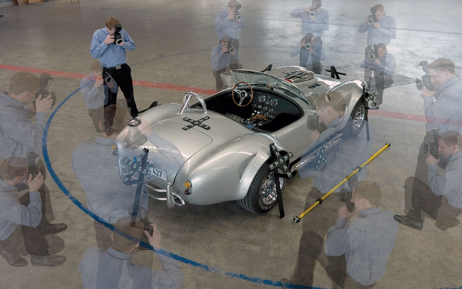
Photogrammetry is the art of making a three-dimensional scale model from a set of photographs taken from different angles. The method uses photographs taken from various angles of an object in order to calculate its dimensions and generate a 3D model by using triangulation.
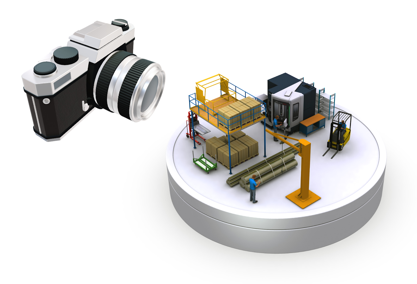
Photogrammetric technologies now extensively use digital cameras and digital computer techniques to measure distances between photographed objects and to enforce those measurements. But that digital camera can come in many forms, from your smartphone to a standard DSLR or even a drone.
In order to create a point cloud with photogrammetry, you need the following tools and software:
- A tripod (optional)
- Data collector (DSLR, drone, mobile mapping camera, mobile mapping system)
- Photogrammetry software
Photogrammetry can be done by any normal person, you, me, … maybe not your grandmother unless she’s pretty savvy with the computer.
The first steps are pretty simple:
- Find an object, place it on a flat surface (if possible), or if you’re out in the world, find an object that isn’t moving.
- Take a picture from as many angles as possible, moving around the object and zooming in and out if necessary to capture the best detail from every angle.
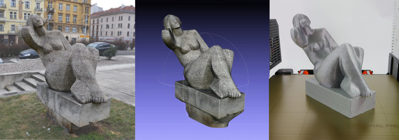
- Download all of the photos to your computer. From here, open up an application such as Meshlab or Autodesk 123D Catch, a free app that helps you convert your photos into 3D models, and hit “import”. Import all of your pictures with one click and then export your model with another click!
- Then you can always upload to a site such as Sketchfab, where you can share your 3D model with others.
What are some uses of photogrammetry?
Just like LiDAR, photogrammetry is used in many industries, including surveying, engineering, construction, manufacturing, geophysics, and archeology.
With the data gathered with photogrammetry technology, the end-user can:
- Create a 3D model of the object being photographed
- Calculate the size and shape of an object
- Measure distances between objects
source: blog.prusaprinters.org
Some specific uses within the above-mentioned industries are:
- In surveying, a point cloud is used to capture the position of objects in three dimensions. This is often done to create a digital elevation model or map.
- In construction, a point cloud can be used to measure the distance between two points or to measure the size of an object.
- Photogrammetry now provides a number of important specializations, including high-precision surveying, mapping, facial recognition systems, and the enforcement of land-use restrictions based on aerial photographs.
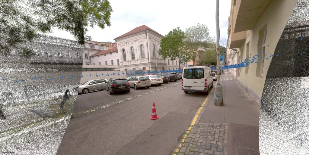
Mosaic CEO Jeffrey Martin was even able to lend his hand during a recent fire disaster in Prague, which completely destroyed a historical landmark. Check out his 3D model of the church, which will help historians recreate the 17th-century wooden church.
What are the core advantages and disadvantages to LiDAR vs photogrammetry when creating point clouds?
LiDAR advantages:
LiDAR has many significant advantages (especially over photogrammetry). It is used extensively in different industries for various purposes. Its advantages include high accuracy, 3D imaging, and high resolution. Here are some of the most important competitive advantages it has:
- provides high-resolution 3D images of the surrounding environment, which is useful for mapping and surveying
- detects objects or hazards in the environment that are not visible to the naked eye
- identifies obstacles or hazards that block the view of the road
- creates highly accurate 3D maps, which are used for localization and navigation. This is possible because LiDAR provides detailed information about surrounding objects on the ground level
- can be used as a scanning tool to inspect objects or infrastructure for damage or defects
- can quickly capture and process data
- offers clean and sharp point clouds that are easy to work with
LiDAR disadvantages:
LiDAR has certain disadvantages when it comes to creating point clouds. One is that it can be an expensive technology to use. It also requires a lot of hardware, which can be difficult to transport and set up in the field. LiDAR often produces very dense point clouds, which can make data processing and downstream analysis more challenging. Additionally, LiDAR data is often not suitable for use in real-time applications.
One of the main sources of error for terrestrial LiDAR systems comes from distortions in the laser beam caused by atmospheric turbulence. These distortions cause the laser light to spread out as it travels through the atmosphere, which can result in inaccurate distance measurements.
The disadvantages of LiDAR include:
- Equipment costs: LiDAR is NOT cheap, costing TENS of thousands of dollars (or euros), meaning it is not accessible to the average citizen or even some small private firms, or local governments with low budgets to work with
- End results are such that you cannot see realistic images, colors, textures, or features
- Post-processing software costs: again, costly and sometimes difficult to manage
- Lower accuracy at night or during other times of poor visibility, such as whiteouts and fog
- Size: systems can be bulky and difficult to transport, which can be a challenge in certain applications
- Sensitivity to environmental conditions such as fog and dust, which can affect the quality of the data collected, making it harder to obtain accurate measurements
- Rainwater negatively affects the accuracy, as the droplets cause the lasers to bounce back
- Can be susceptible to interference from other sources of electromagnetic radiation, such as power lines
Aside from atmospheric effects, other factors that can impact LiDAR measurements include:
- reflectivity of the surface
- topography
- temperature
- humidity
Calibration and validation procedures help to account for and remove the impacts of these factors on data accuracy.
Photogrammetry advantages:
Photogrammetry has several advantages over other measuring techniques.
- First, it is much faster than using a laser or a tape measure to measure the same objects. This makes photogrammetry particularly useful for fast-moving projects such as those that involve cars or airplanes.
- Photogrammetry also has lower error rates than many traditional measuring methods. This means that, by using photogrammetry to create 3D models, engineers and other professionals can produce more accurate measurements and designs
- Photorealistic interpretation of the original model – color, texture, shape, etc.
- There is a much lower barrier to entry, as anyone with a digital camera or smartphone is able to create a 3D model fairly easily
- The costs involved are also significantly lower, again, due to the fact that many cameras on many devices are capable of collecting the data necessary to create a photogrammetry model
Disadvantages of Photogrammetry:
Despite the low costs and low barrier to entry, there are, of course, some drawbacks to photogrammetry. These include:
- One major limitation of photogrammetry is its relative inaccuracy when used with close-up photos (less than about 0.5 meters). This limitation can be overcome by using a precise scale in the photograph or by using a higher-resolution camera.
- Additionally, photogrammetry can be more expensive than traditional measuring methods, especially if high-resolution cameras and software are used. However, as technology improves and the cost of these tools decreases, this may become less of a problem.
- It is significantly slower than LiDAR mapping because it takes hours or days for photogrammetry software to create something that would take seconds with LiDAR technology
- Requires a lot of photos to create a 3D model, especially for large-scale models such as an entire outdoor scene or a city block, a town square, or a building complex
What is the difference in time needed to create point clouds?
Which is faster to collect and process data: LiDAR vs photogrammetry
One of the more common questions asked in regards to which is better for point cloud processing is: which is faster? There are two parts involved here: the actual data capture and the time needed afterwards to process the data and receive the desired results.
Data acquisition speed time for LiDAR and photogrammetry:
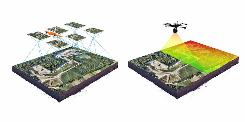
- LiDAR typically requires only 20-30% image overlap between flight lines
- Photogrammetry requires 60-90% image overlap (depending on the terrain and the tools used)
Data processing time for LiDAR and photogrammetry:
- The post-processing of data collected with LiDAR is usually very quick. Raw data only requires several minutes of calibration (between 5 and 30 minutes) in order to produce the final results
- For photogrammetry, it is very time-consuming and requires powerful computers to handle operations on gigabytes of images. So the time spent in the field can be multiplied by 5-10 fold for the data processing side.
- However, there are specific cases for LiDAR when the additional classification may be needed, requiring more time and expensive software
Which is better for creating point clouds: photogrammetry or LiDAR?
As seen above, there are several pluses and minuses to both techniques when creating point clouds:
While both photogrammetry and LiDAR can create point clouds, they also have their pros and cons. Photogrammetry is much slower than LiDAR mapping because it takes hours or days for photogrammetry software to create a 3D model from a set of photographs, while LiDAR technology can capture data in seconds and process it nearly as quickly. The quality of the data from photogrammetry depends on the number of photos from different angles, so poor-quality images can affect the final result. However, with LiDAR, there’s always high accuracy because lasers bounce off surfaces directly back to a sensor.
Making the final decision: LiDAR vs photogrammetry:
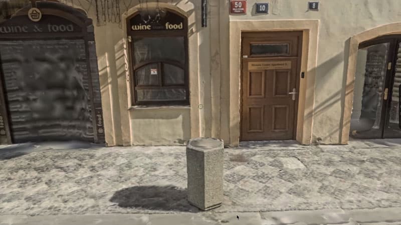
The biggest difference in the output from both techniques is color. Point clouds made with photogrammetry have an RGB value for each point. Or, in common speak, the images you see represent the original image in color in a photogrammetric point cloud, as seen here:
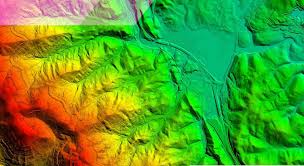
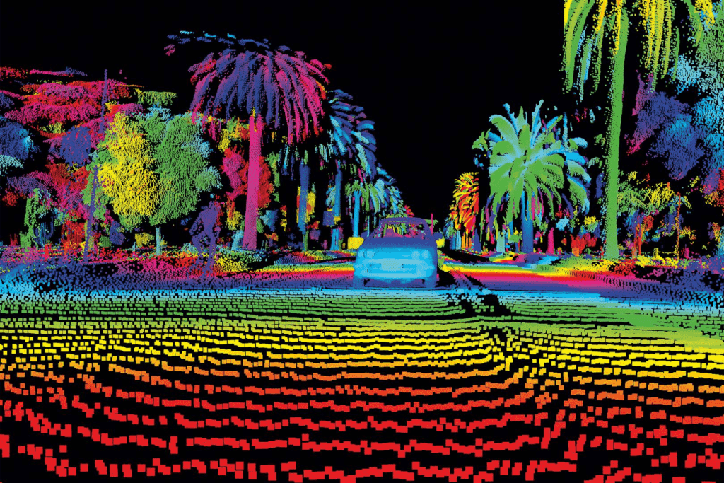
Rather than this very cool, but less realistic representation, we get with a LiDAR point cloud:
So what will it be?
LiDAR:
- highly accurate point cloud
- quick and easy data collection
- relatively easy post-processing
- extremely expensive
- does not (initially) offer realistic colorized point clouds
Photogrammetry:
- very accurate (with enough overlapping photos)
- relatively low barrier to entering the market
- produces highly photo-realistic models and maps
- is much more time-consuming for data capture and post-processing
Stay tuned for an upcoming article on large-scale photogrammetry at scale, with easier data capture than traditional methods.


