
A brief intro to GIS software plus some of the best FREE GIS software available for your use now.
What is GIS software?
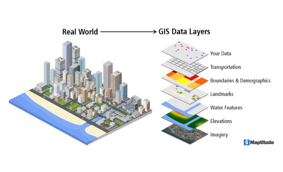
A geographic information system (GIS) enables users to display, query, analyze, and interpret geographical information to better comprehend and solve problems involving linkages, patterns, and trends. Businesses across a variety of geospatial industries and land-centric organizations use GIS to handle geographical data and optimize operations.
GIS software collects, incorporates, and manipulates attribute data from maps to a business’s reporting systems to study and assess real-world problems. Once collected, GIS data typically displays a variety of types of data on a single map to simplify in-depth study and make the most efficient use of available data. The geographic information system (GIS) software is typically used to collect, analyze, and visualize geographic data to manage business operations. GIS applications can be installed on-premise or in the cloud. Typical deployments can result in cost reductions. GIS software frequently interacts with CAD, BIM, and other drafting and design tools to strengthen its analytical capabilities.
To be considered for inclusion in the Geographic Information System (GIS) category, a product must meet the following criteria.
Geospatial data should:
- Be stored, organized, edited, and analyzed
- Incorporate visualization tools for displaying geographic data
- Possess GIS capabilities or make use of a GIS platform in its solution
- Align and alter data originating from maps and other sources
Why use GIS software?
While GIS software is necessary for map creation, it is not the sole application for this technology. These technologies collect data that can be used by small, medium-sized, and corporate enterprises in various industries.
A geographic information system (GIS) enables users to make more informed decisions. When working with a physical site, it’s critical to comprehend its components—air, land, water, and the surrounding environment, among others. A GIS collects this vast array of data, describing various facets of terrain, and consolidates it into a single platform. Visualizing this data enables the identification of future opportunities and challenges, such as the optimal evacuation route during an incoming cyclone.
Geospatial data maintained on these platforms can also be used to answer questions about aspects beyond the physical terrain. A GIS can be used to collect demographic data on the surrounding population and social, real-world business, and political information. Overlapping and data visualization elements help connect the dots and establish correlations between seemingly unrelated characteristics, such as populations and geographic factors. For instance, if a firm needs a new location for a shop, GIS software can locate land near a densely populated area. After that, data can be adjusted to account for inevitable population shifts in the immediate vicinity.
GIS Software and Data Visualization
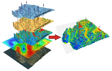
GIS software is purpose-built for data visualization. Reading and comprehending statistics and data can be extremely difficult. Data visualization is a critical component of GIS technology since it ensures that the data entered is presented in a clear and comprehensive manner. Using a GIS solution, you may combine multiple datasets into a single image and discover the links between them. By bringing this data to life, you might also gain a new perspective on a potential problem that needs to be fixed. Multiple maps can be created inside GIS platforms, allowing you to track and see changes in a particular area over time.
Where GIS Software and Data Visualization are Used
As mentioned earlier, GIS software can be used to help visualize data for helping businesses find adequate locations, as well as public safety departments find the safest evacuation routes in emergencies. There are many other industries and use cases for GIS software.
GIS technology can aid in natural resource conservation. Geographic information systems (GIS) software enables the management and maintenance of agricultural, aquatic, and forest resources. Additionally, these technologies make it simple to manage data on forest conditions. GIS technology can be used to examine the geographic distribution of water resources. These two resources are also inextricably linked, as tree cover has been shown to reduce stormwater runoff.
GIS software facilitates the management of geographic information. Numerous entities, such as government and environmental scientific agencies, are mandated to maintain comprehensive geographic information. GIS systems are at the heart of policy development for zoning regulations, population censuses, and property ownership. Maintaining records is critical when developing and enforcing these regulations, and GIS technology can retain essential spatial information.

Additionally, GIS technology can be used to monitor the spread of infectious diseases. Along with charting patterns in geographic features, GIS technology is utilized to track trends in disease distribution. Users can employ desktop GIS tools to compare geography to other relevant characteristics and forecast the possible future spread of an infectious disease. This data helps on-the-ground people to act immediately to save local inhabitants’ lives.
See some incredible maps and mapping platforms created during the COVID-19 crisis.
Benefits of using GIS Software
Time-saving capabilities
GIS software enables the automation of previously time-consuming geographic tasks. Before this technology, obtaining data for any land, environment, map, pipeline, or city planning project could be incredibly time-consuming, as no single platform could take and store data from several sources. Furthermore, each data sample was gathered and stored separately. However, GIS tools operate as a repository for this data and, if necessary, transform it to the appropriate format. GIS technology then takes this a step further by allowing users to design, update, and edit their geographic data within the same platform that stores it. Additionally, these solutions provide analytical tools, which free up businesses’ time to focus on other pressing and vital responsibilities.
Cost-efficiency
Governments can employ GIS software to plan more cost-effective communities. When it comes to creating and growing their communities, governments rely on meticulous planning. However, government entities, notably smaller municipal ones, may experience economic difficulties. Expansion of society while resources are depleting becomes too expensive. Government organizations can use GIS technology to expand their communities in the most cost-effective manner possible. The data given by GIS software enables them to make better-educated decisions about land use and the location of physical amenities. Governments can continue to save expenditures by utilizing a free GIS solution.
Efficient design
GIS technology enables districts to design more efficient schools. A frequent occurrence in communities is the necessity to redistrict school borders as the local population fluctuates. Geographic information systems (GIS) programs collect and store addresses for all pupils at a school. You can adjust the borders of these zones using feature-based proximity tools, and a GIS correlates the student numbers by grade for this proposed boundary. Even after school district boundaries are established, these programs can help schools. School administrators analyze the distance pupils walk to school using GIS technologies. If a kid resides a specified distance away, GIS tools continue to evaluate the data to identify which pupils qualify for school bus transportation. Because schools may not have a large budget allocated to non-essential technology, they can accomplish these duties by utilizing a free GIS platform.
Safety
GIS technology can be used to plan for natural catastrophes. One of the primary applications of this software is environmental protection. On the other hand, citizens must be protected from potential threats in their local environment. GIS tools aid in risk management by identifying areas that are vulnerable to natural or man-made calamities. Following that, communities can use this data to design preventative strategies. And, if natural calamities are unavoidable, GIS technology can still be beneficial. These tools assist in planning emergency evacuation routes and in estimating flood damage. Additionally, GIS enables local governments to document the extent to which they require federal disaster relief money.
How to get GIS Software
GIS software is generally available in two formats: open-source and commercial.
Open-source GIS software is free, and the source code is publicly accessible, which means that anybody can study and modify it. Generally, free GIS software lacks the features and support of commercial GIS. However, some open-source alternatives remain pretty powerful.
On the other hand, commercial GIS is a subscription-based service or a one-time pay-per-user. Although the premium choices can be highly costly, these systems typically offer more frequent upgrades and enhanced functionality.
Open-source GIS software is an excellent alternative for companies on a shoestring budget or anyone interested in learning GIS without making a significant financial commitment. While free GIS platforms may lack some features, they are often highly robust: capable of handling a wide variety of geospatial mapping and analysis activities.
Best Free GIS Software Applications
QGIS 3 – free GIS software
This is one of the best GIS software applications available. When QGIS publishes a new version, it’s a significant event because open source GIS software’s unsung heroes have returned! This is their third significant release. QGIS version 3! QGIS 3’s DNA is infused with open source. It has been genetically engineered to break the mold of commercial geographic information systems.
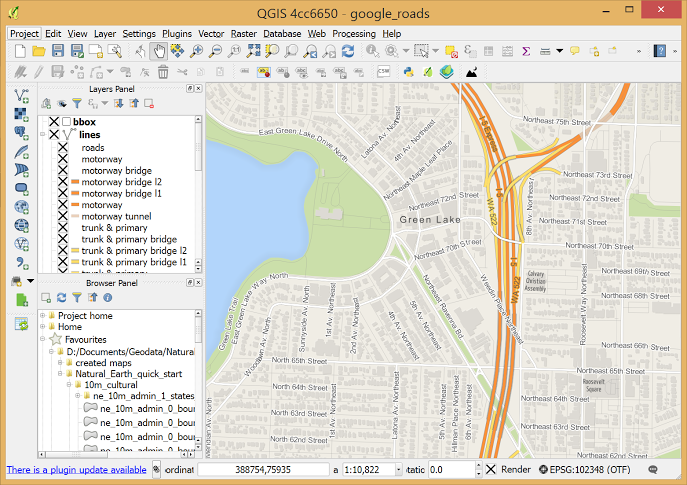
QGIS 3 is the most forward-thinking release. For instance, it introduces an entirely new set of cartography, with all the convenience that entails. In addition, there is now 3D mapping, mesh generation from other data types, additional spatial analysis tools, symbology, and user interface enhancements. It also supports advanced database interaction functionality that was previously reserved for the DB Manager plugin.
gvSIG – free GIS software
After QGIS, gvSIG is the next best free GIS software option. Its capabilities are grossly underestimated. It includes a field application, 3D capabilities, and a desktop application.
Despite the absence of English documentation, the gvSIG project is simple to pick up and use. The NavTable is agile in that it enables you to view records vertically one by one. gvSIG’s CAD tools are quite impressive. You may trace geometries, change vertices, snap and split lines, and polygons with the OpenCAD Tools. If you require GIS on your mobile device, gvSIG Mobile is the best GIS software option because of its user interface and GPS tools.
GeoDa – free GIS software
GeoDa is a free GIS software program predominantly used to educate new users about spatial data processing. Its primary role is statistical data exploration.
One of the best features is that it comes with sample data for you to experiment with. GeoDa provides a comprehensive set of statistics for practically any spatial task, from simple box plots to regression statistics.
It has a sizable user base. For example, Harvard, MIT, and Cornell institutions have embraced this free GIS software as a means of introducing non-GIS users to spatial analysis. It has been employed in various fields, from economic development to health and real estate, and as an intriguing analytical tool in laboratories.
ILWIS – free GIS software
Users of free GIS applications can rejoice—previously commercial GIS software, now open-sourced, is available. ILWIS (Integrated Land and Water Information Management) is a tried-and-true method of managing land and water information.
The extinction-resistant ILWIS is a free geographic information system (GIS) designed for planners, biologists, water managers, and geospatial users. ILWIS excels in the fundamental tasks of digitizing, editing, and displaying geographic data. Additionally, it is utilized for remote sensing, with capabilities for image classification, augmentation, and alteration of spectral bands.
It has gradually increased its support for time series, 3D analysis, and animation. While some struggle with some of the fundamentals, such as layering. Nevertheless, the documentation is comprehensive, and the application has a sizable user base.
Mobile mapping services and GIS
One of the best tools for gathering the data necessary for GIS software is a mobile mapping system – a device consisting of several technologies for gathering images, geographical locations, and other environmental details.
Traditional mobile mapping techniques are evolving, and many maps are struggling to stay up to date. Governments and private sector organizations are increasingly requesting real-time, highly accurate street-level maps of their cities, surroundings, and communities.
However, the available instruments are insufficient for the task. Their low-resolution photos are unsuitable for creating 3D models, digital twins, or preparing for augmented reality platforms.
Mosaic’s mobile mapping services use the highest-resolution 360-degree cameras available, which are purpose-built for mobile mapping. The high-resolution photos (12K – 20K) boost productivity and efficiency on a large scale.
MOSAIC 51
The versatile, all-in-one solution is resistant to cold, heat, rain, snow, and muck. With an integrated computer, it is designed for the road, regardless of the terrain or environment. The industrial design, IP67 rating, and replaceable lens covers ensure it will return home in the same condition it left. Still, this time brimming with high-definition photographs captured by the 6 x 12MP image sensors.
MOSAIC X
Capture pictures to create 3D representations of streets and their surroundings. The Mosaic X enables users to collect photographs for photogrammetry at motorway and highway speeds, allowing for faster and more accurate development of maps and models of their environment.
MOSAIC VIKING
Maps vast spaces independently, rapidly, and efficiently, creating an unsurpassed, detailed 3D model. We are assisting augmented reality in making enormous strides forward by developing completely authentic models of our world. The Mosaic Viking 360 has been designed to capture the world. It features six 31MP sensors for a total resolution of more than 180 Megapixels.
Concluding on free GIS software for visualizing data
If you’re just starting out in the surveying field – whether for your local government or a private organization – and you need to splice together several layers of data, GIS software can help. With it, you gain a better understanding of your community and your neighborhoods. It could be related to population, economic status, political beliefs or affiliations, physical landscapes, utilities present or not, and many other factors.
This is the power of GIS, and this is why GIS software, and more importantly, free GIS software, is so important. It is helping to democratize data that was once out of reach for the vast majority of us. And this is why we’re so excited about its possibilities, and all that it has done already.
What about you? How do you use it? How will you use it?


