How Carrier Geomètres Experts boosts Leica Geosystems TRK data quality with Mosaic X
Carrier Géomètres Experts is a precision surveying firm based in Haute-Savoie, France, specializing in topographic surveys and highway clearance missions across demanding Alpine terrain. When the panoramic camera embedded in their existing TRK700 system could no longer deliver the image detail their projects demanded, they began looking for a solution that would let them see more – and deliver more. They found it in the Mosaic X camera system.
At a Glance
| Customer | Carrier Géomètres Experts |
| Location | Haute-Savoie, France |
| Website | carrier-geometre.com |
| Industry | Topographic Surveying & Highway Clearance |
| Products Used | Leica TRK700 + Mosaic X 360º camera |
| Integration Platforms | ATIS Cloud, HXDR (Leica Geosystems) |
| Problem | Native camera unable to deliver the image detail required for sign reading, asset identification, and façade surveys – limiting the contracts Carrier could win |
| Solution | Mosaic X added to the existing TRK700 workflow, delivering 91.2MP panoramic imagery with zero-offset point cloud alignment – no pipeline rebuild required |
| USPs | Flexibility · ROI · Tender Compliance · Best-in-Class Combination |
The Customer: Carrier Géomètres Experts
Founded and led by Philippe Carrier, a Géomètre Expert (Chartered Surveyor) based in Haute-Savoie, the firm operates in environments where precision is not optional. Their core work – topographic surveys and highway clearance missions – requires panoramic imagery that holds up under forensic scrutiny: tight mountain roads, infrastructure corridors, and built environments where every detail has contractual and legal significance.
With seven agencies spread across Haute-Savoie, Carrier serves local authorities, real estate developers, and private clients across one of France’s most geographically demanding regions.
Working within the Leica Geosystems ecosystem, Carrier had built their workflow around the TRK700 mobile mapping platform – one of the most accurate MMS systems available. As project scopes expanded to require higher-resolution panoramic imagery for detailed asset identification and sign reading, they began looking for a camera that could extend what the TRK700 already delivered so well.
The Challenge: Resolution Was Holding Them Back
Carrier originally reached out to Mosaic nearly 2 years before the final acquisition of their Mosaic X system. Late 2023 marked the beginning of a 20-month evaluation journey to add high-resolution panoramics on their MMS system.
The core problem was straightforward: 24 megapixels was no longer enough.
For Carrier’s survey work, the ability to extract meaningful data from panoramic imagery – reading text on road signs, identifying electrical equipment by type, verifying building plates and façade details – is not a nice-to-have. It’s the product. When 360º panoramic imagery can’t be zoomed into without breaking down, surveyors either have to go back to the field, deploy additional resources, or deliver lower-quality data to the client.
The TRK700’s embedded system also tied Carrier to a proprietary workflow. Any upgrade would need to integrate cleanly into their existing LiDAR-based pipeline and work seamlessly with the platforms their clients and collaborators already used.
“Our previous solution was limited to 24 megapixels, which did not meet the level of detail our projects required.”
- Philippe Carrier, Géomètre Expert, Carrier Géomètres Experts
Finding the Right Solution: The Leica–Mosaic Connection

Carrier discovered the Mosaic X through a combination of online research and professional trade shows – a path that will be familiar to many in the geomatics community. But the decision to move forward was also shaped by a recommendation from Raphaël Goudard at Leica Geosystems, supported by the work of Gil Alves, Mobile Mapping Application Eng. also at Leica.
“I recommended Mosaic X to CGE for its straightforward integration, system flexibility, and the strong professionalism of the team in supporting customers.”
- Raphaël Goudard, Mobile Mapping Director of Sales and Business Development in the Reality Capture and Geosystems Division
This partnership dimension matters. For firms operating within the Leica ecosystem, the ability to get support from both Mosaic and their existing hardware partner reduces deployment risk and simplifies troubleshooting. For Carrier, it was a practical consideration as much as a technical one.
For firms already operating within the Leica ecosystem, the Mosaic X integration makes commercial sense on four levels.
First, flexibility – the combination is not always-on; firms deploy it selectively on projects where high-resolution panoramic imagery is required, leaving the existing TRK700 workflow untouched for everything else.
Second, ROI – 91.2MP panoramic imagery opens up contract categories that 24MP panoramic imagery simply cannot compete for: sign inventories, infrastructure asset identification, highway clearance documentation, and façade surveys.
Third, tender compliance – public sector and infrastructure tenders increasingly specify resolution and data format requirements that embedded cameras cannot meet; the Mosaic X does.
And fourth, it is simply the best-in-class combination available: the most accurate MMS on the market paired with the highest-resolution 360° camera, delivering a unified georeferenced dataset that neither system could produce alone.
Implementation: Smooth Onboarding, Seamless Integration
Philippe describes the onboarding process as going “very smoothly” – a reflection of Mosaic’s support model, which prioritizes direct responsiveness over ticket queues. The Mosaic team remained accessible throughout the calibration and setup phase.
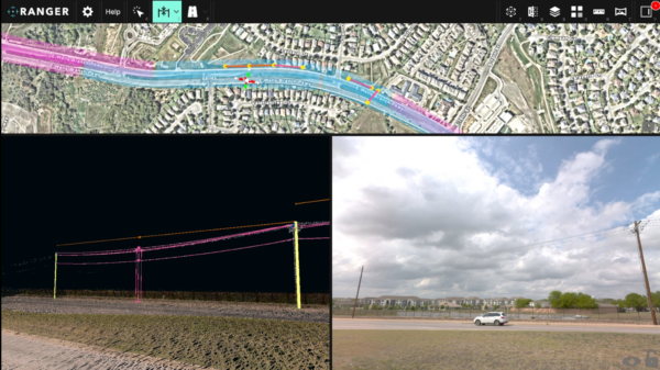
The technical integration required some workflow adjustments, as any new system does. The key milestone was completing the calibration between the LiDAR point cloud and the Mosaic X’s panoramic imagery. Once achieved, the results were immediate: a perfect overlay between the two datasets on both ATIS Cloud and HXDR, with no spatial offset between point cloud and panorama.
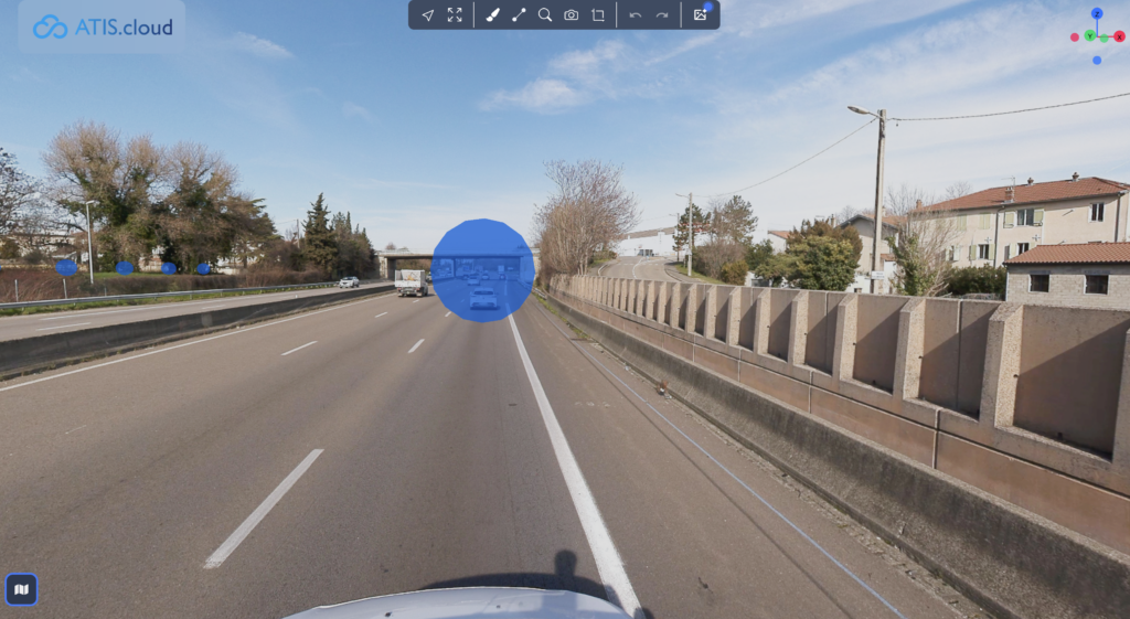
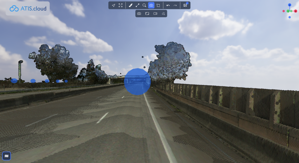
“We achieved a perfect overlay between the point cloud and the panoramas – with no offset between the two. This is a significant added value for our workflows.”
- Philippe Carrier, Géomètre Expert
For a surveying firm, that alignment is not a minor detail. Offset between point cloud and imagery is a common source of post-processing rework – cross-referencing, manual correction, and quality checks that consume hours per project. Eliminating it at the capture stage changes the economics of every mission.
Post-delivery, the team encountered a technical challenge familiar to any surveying firm working across coordinate systems: Mosaic cameras output imagery in UTM/WGS84, while Carrier’s French projects require Lambert 93 – the national projection standard. The original e57 export was also losing color and classification data in the process. Rather than leaving Carrier to resolve this alone, Mosaic’s technical team worked directly with both the Leica team and ATIS to solve it at the source. The fix was collaborative, fast, and complete.
“Mosaic’s support and reactivity have been excellent. The team worked closely with Leica and ATIS to handle the coordinate projection and e57 export configuration”
- Thomas Durand, Technicien Géomètre, Carrier Géomètres Experts

Results: What 91.2 Megapixels Makes Possible
1. Reading the field from the office
The Mosaic X does not change what Carrier’s Leica TRK700 does – it expands what the combination can deliver. The result is a more flexible, more commercially competitive survey operation.
The headline capability unlocked by the Mosaic X is the ability to zoom into panoramic imagery captured at up to 30 metres with enough clarity to read text – on road signs, electrical equipment labels, shopfront façades, and building address plates. For a topographic surveyor, this is transformative: it converts what was previously a field visit into a desk task.
This has direct implications for a range of survey deliverables:
- Road sign inventory and condition assessment
- Electrical infrastructure identification (pole type, equipment nature, markings)
- Building and property boundary verification
- Highway clearance documentation
- Façade and signage survey for urban compliance
2. Point cloud + panorama: zero offset
The perfect calibration between LiDAR point cloud and panoramic imagery means Carrier can upload both datasets to their cloud platforms and deliver them to clients as a unified, spatially coherent product. There is no manual correction step, no offset to account for in post-processing. The data is ready.
3. Seamless coordinate system support across national standards
French surveying projects require Lambert 93. Mosaic cameras output UTM/WGS84. Rather than leaving this as a post-processing burden, the Mosaic, Leica, and ATIS teams resolved the projection alignment and e57 color/classification export jointly – demonstrating that the integration is supported end-to-end, not just at the point of sale.
4. New application possibilities
Philippe notes that the level of detail achievable with 91.2MP “opens up many new application possibilities”. The reaction from the Leica Geosystems team during an on-site results presentation was, in Philippe’s words, unanimous: the quality is truly impressive.
5. Validated by the Leica ecosystem
The fact that Carrier presented their Mosaic X results to the full Leica Geosystems team – and received unanimous positive feedback – is significant. It signals that the Mosaic X’s integration with Leica’s hardware and software platforms is not just technically functional, but delivers panoramic imagery quality that satisfies one of the most demanding hardware ecosystems in the geomatics industry.
Philippe Carrier of Géomètre Expert being interviewed by Jeffrey Martin – CEO and Co-founder of Mosaic at Geo Week 2026 in Denver, CO.
Looking Ahead
Carrier Géomètres Experts are still in the early stages of deploying the Mosaic X at scale – but the direction is clear. What began as a resolution problem has become a commercial opportunity. With 91.2MP panoramic imagery integrated directly into their Leica TRK700 workflow, they can now pursue contracts that were previously out of reach, meet tender specifications that 24MP could not satisfy, and deliver a unified, georeferenced dataset that neither system could produce alone.
Philippe Carrier himself is confident the system will be central to winning new contracts in sectors where image quality is a differentiating factor – a list that, based on what 91.2MP makes possible, extends well beyond their existing topographic and highway work.
For surveying firms already invested in the Leica ecosystem, the question is no longer whether the Mosaic X is compatible. Carrier Géomètres Experts – and Leica’s own team – have answered that. The question is how many projects are currently being left on the table because the embedded camera isn’t enough.
Looking to learn more about this integration with your TRK system or any other mobile mapping system?
Contact us below and we’d be happy to answer your questions.