
A sizeable area of our world is not mapped. Who is being forgotten, and how can we make sure they are seen? With an easier-to-use, faster workflow and cheaper solution! Find out how.
Unmapped and off-the-grid communities can mean disparities across the world, whether for day-to-day tasks or during major natural disasters. How can the geospatial world help rectify this?
The Importance of Mapping
Right now, more than one billion people are living in places that are not mapped.
This is a shocking statistic, but perhaps only fully impactful once you realize what this means for the unseen communities.

Mapping data is an integral part of the modern digital ecosystem and is critical to unlocking economic, social and environmental opportunities for sustainable growth, development and climate resiliency.
PLACE (Mosaic customer)
It is almost taken for granted that we have the accessibility we have in daily life. If you want to look up restaurants in a 5km radius, this takes seconds. Locating your nearest embassy to handle paperwork is easy. Working out a travel route to your job interview the next morning? Public transport routes and times are marked clearly, ensuring you arrive a touch early for a quick breath outside.
Map inclusivity isn’t just about finding a nearby spot for lunch or the office of your soon-to-be employer. It’s about the inhabitants of a community having a frame of reference, a starting point for growth.
This isn’t just referring to tourists, this encompasses builders and relief workers. How do people visiting an unmapped area know where to go? How do they get there? And what tells them that they have arrived at the correct place?
Even for those who have arrived to map the area, how on Earth can they associate the data collected with where they are standing right now? Google Maps’ inclusivity is highly important.
Think of organizing a meeting place with absolutely zero frame of reference. Organizations exist with the sole intention of getting these forgotten communities on the map, and getting to the right place to begin work is half of the challenge.
What is it Like Living in Unmapped Areas?
For locals, it’s manageable. Manageable in the sense that they can navigate the streets simply by using their experience and knowledge of the area.
Maintenance is made somewhat more difficult, especially for outsiders, as information relies heavily on the locals’ communication to guide them to the right place. Road and asset monitoring are essential for the upkeep of towns and communities, and the collection of data is considerably more time-consuming when there is no set map for an area.
In mapped areas, data is collected and compared frequently for local municipalities to maintain order. Energy suppliers use the data to maintain gas, electricity, and water lines. Road signs, road surfaces, and street lighting are monitored for repairs and expansion plans.

Not just roads, but environmental features such as rivers and parks, landmarks like local churches, and infrastructure all need to be noted to form a fully complete and identifiable map. Having accurate and, more importantly, current data is essential for towns to expand and grow.
Unmapped areas do not have this. How can energy or telecommunication companies expand their network, and how do local governments maintain a safe environment for their inhabitants without a framework to work from?
Check out this video to learn more about surveying for the telecommunication industry.
Why are some areas like this? Simply put, companies do not prioritize smaller communities because they cannot generate revenue. Companies that prioritize advertising opportunities and data selling over the care of the area’s inhabitants.
Extenuating circumstances such as natural disasters and the 2020 pandemic changed everything completely.
The Importance of Inclusivity in Mapping Google Maps Inclusivity
Natural disasters are increasing in number globally. For even the richest and considered most developed countries, these can still be catastrophic. Help pours in from all sides, and relief organizations and charities begin work locating people, providing care and aid, and starting the task of rebuilding.
Let’s go back to the above. The relief workers arrive and…then what? There’s no map, no directive, no clue where settlements are, and no previous data on lakes to focus on potential flood-risk areas. The issues are endless, and in a time-sensitive situation such as a natural disaster, failing to map these areas costs lives.
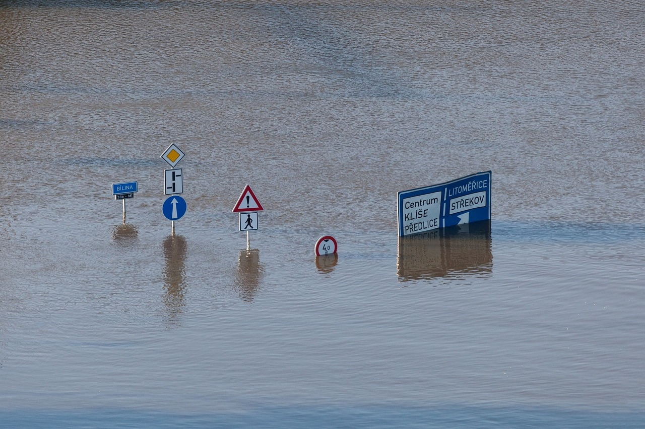
Here we discuss how and why the collection of accurate and high-quality data is so crucial in post-disaster management and recovery.
What’s Being Done – Issues with Current Mapping Methods
Organizations, such as the Humanitarian Streetmap Team, visit these places and map them. However, these mapping systems are often offline, and once the organizations have left the area, the data can quickly become out of date because keeping up-to-date maps has typically been too expensive and too time-consuming. (But stick around to find out how that is changing!).
There are also projects for locals and volunteers to contribute to and help map. OpenStreetMap is a tool for doing exactly that. Cartographers analyze satellite imagery and pick out details to form a base map. On average, for this tool, each time a volunteer uses it, they map an area of less than 10km. Locals can then pick out the buildings and mark them.
Every contribution is welcome, and the maps created have done incredible things, such as freeing people trapped in rubble after earthquakes and providing polio vaccines to children. Without these maps, rescuers might not have found these people.

Although these maps have made a real change, this method is not the most accurate or fastest. Relying on crowd-funded data is not efficient or accurate. We need a systematic approach by one provider to map the areas methodically.
There are organizations that are starting to do that, including PLACE. They state:
Our MISSION is to map the urban world in ultra-high resolution and make these maps open, reliable and accessible.
So why did PLACE choose to work with Mosaic?
360° Mapping with Mosaic
Collecting imagery with a standalone 360° mobile mapping camera, which also gathers geo-referenced points is the perfect solution. When visiting unmapped communities, getting the best data upfront saves time and resources and limits the need for quality assurance from volunteer contributions.
Mosaic cameras are an improvement over previous mobile mapping systems. Their innovative design allows for an easier, faster, and significantly cheaper way of collecting highly accurate street-level imagery, enabling us to map more of the global community.
Our Mosaic 51 camera is a robust, high-resolution 360° camera with the below outstanding features:
12.3K Resolution Camera
Six high-resolution lenses capture street-level image details at a distance and produce much higher quality than the previous industry standard cameras.
Purpose Built
A comprehensive system that encompasses GPS and data storage, without the need for any additional workstation in the back seat.
Tough
A robust frame and connectors withstand the harshest of environments. From searing heat to freezing temperatures, this system is waterproof, dust-resistant, and capable of taking on the most rugged of terrains.
Single Manned Operation
One person can easily affix this unit to the roof of a car. It is lightweight to move and straightforward to use with minimal training required.

Using technology like this would ensure the unseen communities are on the map and would help save lives.
Google Maps Inclusivity for all
It isn’t just smaller communities that aren’t included on Google Maps.
Sevier County in Tennessee has a multitude of back roads that are unchartered. We’ve been in contact with them and they’ve since rigged up a buggy with one of our 360° cameras.
Watch out, world, Sevier County Road Department is moving up! Many thanks to the Mosaic – Geospatial Imaging Leaders team for getting us up and running. If anyone needs a 360-imaging camera, I can’t recommend the Mosaic51 enough!
Pamela Blackmore, GIS Technician
Check out this awesome video of one of our Mosaic 51 cameras atop a 4×4 offroad vehicle.
A highly developed country like Denmark is only 70% mapped. This will slow the growth as the country does not have a fully mapped framework to work with.
Using one of our cameras, engineering and environmental mapping company COWI mapped 98% of the country in less than 4 months.
The speed and accuracy with which this can be achieved are astounding. The work and aid that would result in a fully mapped earth would be monumental.
Conclusion
This doesn’t mean that mapped areas are without their faults.
Earlier this year, drivers in Egypt found themselves following GPS navigation that had taken them on longer routes, or to roads that were completely closed.
When we consider that Egypt’s population reached 103 million in February and that the total number of licensed vehicles on the road is at a heavy 10.8 million (data from 2020), this will cause some substantial difficulties.

Maintaining Google Maps inclusivity requires several levels of input from a huge amount of people around the world.
‘The online mapping platform mainly relies on a combination of different information and data sources, including third-party data, information from local authorities, and contributions from the Google Maps community, an online platform for the app users; along with Street View, a technological tool featured in Google Maps; in addition to images collected from the satellites.
It uses a variety of sources to get the most accurate and up-to-date information on the map, and it uses a combination of manual and automated techniques to check for accuracy.’
Roadwork, new infrastructure, and traffic lanes are not always updated, causing frustration to a proportion of those 10 million listed above, particularly to those who are perhaps over-reliant on GPS navigation.
Interestingly, when asked, a local explained he recently preferred to use street signs over GPS.
We’ve come a long way from unfolding mammoth tent-like maps in the car to squinting at tiny colored wriggles on paper. GPS mapping has shown that it is incredibly important for a multitude of reasons. Whether we become over-reliant or not, Google Maps’ global inclusivity is a need that must be addressed.


