")
Understanding the critical role of perishable data captured in disaster recovery
Discover why capturing perishable data post-disaster is crucial for effective recovery efforts and how innovative technology like Mosaic Camera Systems are transforming the game. Sit back, strap in and check out the critical role of data capture in disaster recovery in order to understand:
- Why capturing data quickly is essential, especially when every hour counts in making life-saving decisions.
- How capturing perishable data helps responders adapt to evolving disaster zones, facilitating more efficient recovery efforts.
- How perishable data aids in pinpointing survivors’ locations swiftly, potentially saving countless lives.
Introduction
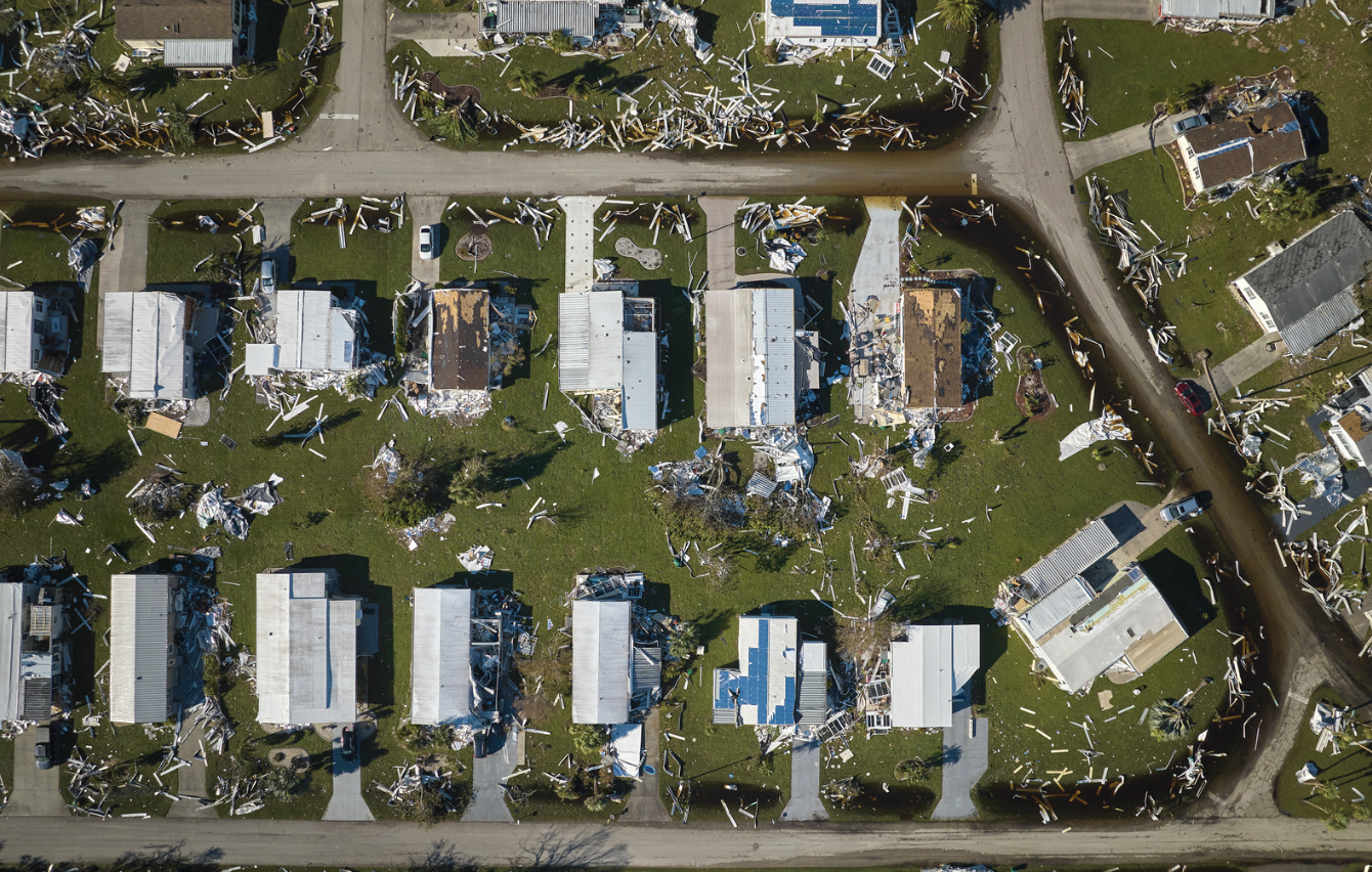
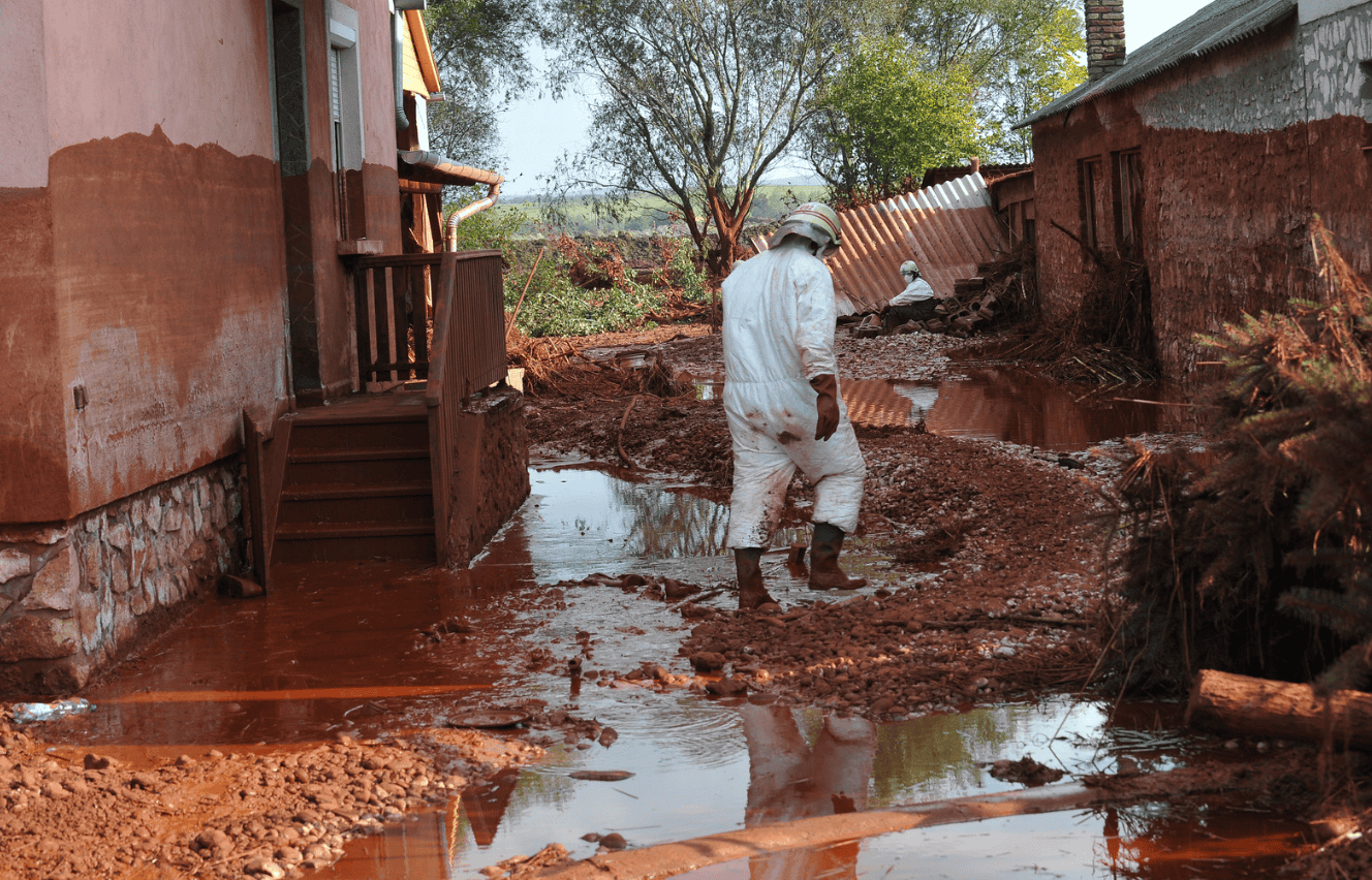
Disasters, whether natural or man-made, leave a path of destruction. In the chaos that follows, collecting accurate information quickly becomes critical for a successful rescue and rebuild. Some data, however, has a short shelf life. This “perishable data” is incredibly valuable but can disappear quickly if not captured immediately.
According to the Federal Emergency Management Agency (FEMA), a staggering 40 percent of companies fail to resume operations following a disaster, with an additional 25 percent succumbing within a year.
Drawing from insights provided by FEMA, it becomes evident that businesses face profound risks in the wake of calamities. However, amidst these challenges lies an opportunity for proactive measures to mitigate the impact of disasters. Moreover, the prudent adoption of adequate insurance coverage serves as a lifeline, enabling swift recovery and ensuring the resumption of business activities.
This article will explore why perishable data is so important after a disaster and introduce the industry’s newest ‘go-to’ technology – our line of Mosaic Camera 360º Systems – that’s changing the game for post-disaster data collection.
Why Perishable Data Matters
The Clock is Ticking
Perishable data is important because it’s time-sensitive. After a disaster, certain information becomes more valuable with each passing hour. The state of roads, power lines, or bridges is valuable data for emergency response crews.
This data can quickly become outdated, so capturing and analyzing it quickly is essential for making the best decisions about where to send help.
A Changing Landscape
Disasters can completely transform an area. Floodwaters rise and fall, fires leave scorched earth, and buildings crumble. Capturing perishable data right away allows responders to document these changes and understand the evolving situation. This information is crucial for planning and carrying out effective recovery efforts. Without properly understanding the amount of damage a vital piece of infrastructure has sustained after a flood, it’s difficult to know if it’s safe to use for rescue efforts. By adapting strategies based on the latest data, disaster management teams can work more efficiently.
Search and Rescue Operations
When a disaster hits, locating survivors quickly becomes the most important task. Perishable data plays a critical role in these search and rescue operations. Having information like the last known locations of people in the affected area, or being able to pinpoint areas where survivors might be trapped are vital details. This kind of time-sensitive data can be the difference between life and death. The faster responders can gather and analyze this data, the sooner they can reach those in need, potentially saving countless lives. Delays in capturing perishable data can mean the difference between a successful rescue and prolonged uncertainty for families, adding to the emotional toll of the disaster.
Assessing the Damage
In the aftermath of a disaster, responders need to understand the full extent of the damage as quickly as possible. This is where perishable data related to critical infrastructure comes in. Information about damaged roads, bridges, and buildings helps authorities assess the impact on the infrastructure network. With this knowledge, they can prioritize which areas need immediate attention and allocate resources effectively. This can help prevent further damage, like a bridge collapse due to undetected cracks, and ensure smoother delivery of vital supplies to affected areas. Perishable data acts as a roadmap to recovery, guiding response efforts and ensuring a quicker return to normalcy for communities.
After the Storm: How Perishable Data Helps Us Recover
When disaster strikes, the chaos can be overwhelming. But amidst the destruction, there’s a crucial race against time – the race to gather information. This information, called “data,” becomes especially valuable the sooner it’s collected.
Making the Right Calls with Data-Driven Decisions
Picture a disaster coordinator trying to decide where to send rescue teams after a flood. Without any data, they might be sending rescuers in random directions, wasting precious time. But with solid, up-to-date data, they can see which areas have the most people in need, or where roads are still passable. This kind of data helps decision-makers choose the best course of action, leading to more effective disaster response.
Enhancing Disaster Response with Site Tour 360’s Street-Level Imagery
The seamless integration of data-driven decision-making and technological advancements has revolutionized disaster response efforts. Among the pioneers in this field is Site Tour 360, a reality capture and mapping consultancy. Specializing in geospatial projects, Site Tour 360 collaborates closely with organizations like FEMA and the National Disaster Preparedness Training Center to provide critical support in crisis situations.
In the aftermath of natural disasters like Hurricane Ian, swift and accurate assessment of affected areas is paramount. Site Tour 360’s innovative use of their Mosaic 51, a 360º mobile mapping camera, in conjunction with their expertise, significantly expedited post-disaster surveying and data processing. Leveraging their powerful workflow, they were able to capture street-level imagery and make it live within 24 hours of the disaster, offering invaluable insights for decision-makers.
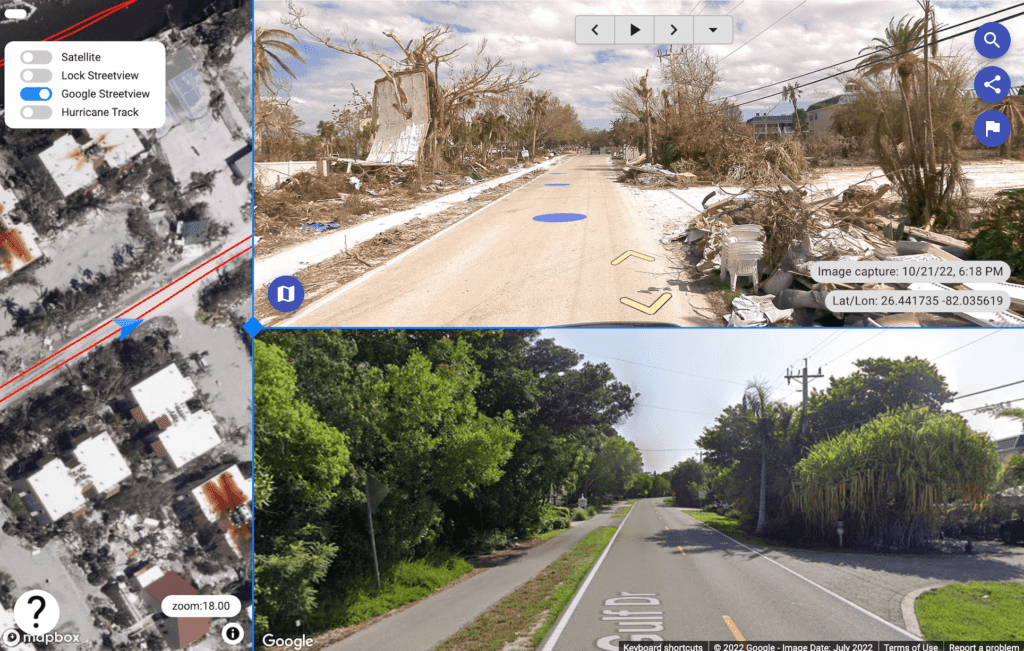
The result of Site Tour 360’s workflow, utilizing Mosaic 51 camera data and 360Camsters viewing platform.
This capability directly aligns with the essence of data-driven decision-making highlighted in the preceding sections. By swiftly providing high-resolution imagery of disaster-stricken areas, Site Tour 360 enables authorities to make informed decisions regarding resource allocation and response strategies. Such rapid and comprehensive data collection empowers disaster coordinators to prioritize areas with the greatest need, thereby optimizing rescue efforts and minimizing response time.
“We’ve gotten to where we can basically have stuff live within 24 hours, which we couldn’t do before…people were very surprised at how quickly we were capturing, processing, and publishing…basically it would be live the next morning.”
Dylan Faraone of Site Tour 360
This highlights the remarkable achievement of Site Tour 360 in capturing, processing, and publishing data within 24 hours, a speed previously unattainable, impressing stakeholders with their efficiency.
The success story of Site Tour 360 serves as a testament to the transformative potential of technological innovation in disaster management. Their collaboration with Mosaic’s 360º mobile mapping camera underscores the significant role of advanced imaging technology in enhancing situational awareness and facilitating proactive disaster response.
Sharing What We Have: Resource Allocation
After a disaster, there are never enough resources to go around – people, supplies, equipment – it’s all stretched thin. Data helps authorities understand where these resources are needed most. Visualize a map showing areas with high population density, damaged infrastructure, and limited food supplies.
This allows authorities to target their efforts, sending food trucks to areas in need of food and fresh water, as well as repair crews to damaged infrastructure. In short, data helps them get help quickly to the people and places that need it most.
Learning from the Past: Planning for the Future
Data isn’t just useful for the immediate aftermath. By studying the data collected after a disaster, communities can learn from the experience and prepare better for the next one.
By analyzing data on flood zones and building stronger levees in those areas, “mitigation planning” helps communities become more resilient, meaning they can bounce back from disasters quicker and with less damage in the future.
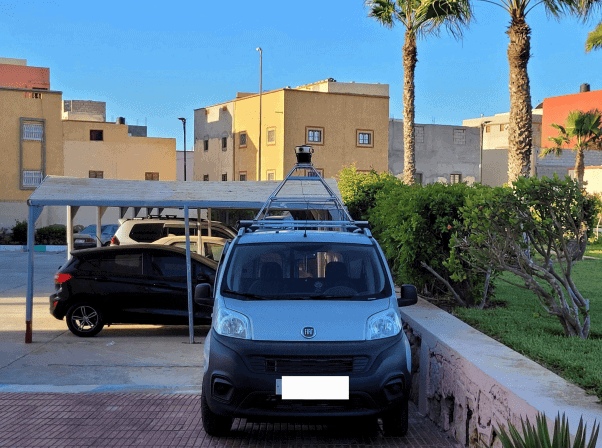
New Tools for a Tough Job: Mosaic Camera Systems
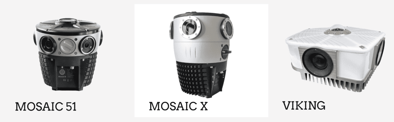
Just like firefighters have special equipment to battle blazes, disaster response teams are using cutting-edge technology to collect data faster and more efficiently. One such technology are the Mosaic Camera Systems, particularly the Mosaic 51 and Mosaic X Camera Systems. These innovative tool capture reality with high-resolution images from the street level for photorealistic ground truth, giving responders a detailed picture of the disaster zone. This allows them to see the damage from every angle, helping them make informed decisions and saving valuable time.
Mosaic Camera Systems are emerging as a game-changer in disaster response. These innovative systems boast several features that significantly improve data capture after a catastrophe.
Your All-In-One Solution
Mosaic Camera Systems excel in capturing and storing data internally, providing a robust all-in-one solution, including internal storage and onboard GNSS. This onboard storage feature eliminates the need for intricate setups or relying on external computers for data storage, significantly reducing potential points of failure.
The stored data is easily accessible and delivered in a non-proprietary format, ensuring seamless processing and sharing with relevant decision-makers.
Furthermore, the system’s independence from network connectivity or data uploads mitigates concerns regarding potential data breaches or loss during capture, enhancing data security and reliability.
This internal storage capability offers several benefits:
- Streamlined Setup: With onboard storage, Mosaic Camera Systems simplify deployment, requiring no complex infrastructure or additional equipment within vehicles for data storage.
- Data Integrity: By storing data internally, the system mitigates risks associated with network connectivity issues or data transfer failures, ensuring the reliability of captured information.
- Enhanced Security: The absence of reliance on network connections eliminates vulnerabilities to hacking or data breaches, bolstering the security of sensitive information.
- Efficient Data Management: The system’s non-proprietary data format facilitates seamless processing and sharing with relevant stakeholders, enabling swift decision-making and response coordination.
In essence, Mosaic Camera Systems empower users with comprehensive data collection capabilities while ensuring operational efficiency, security, and reliability in fast-paced scenarios.
Reaching the Unreachable
Mosaic Camera Systems are built for autonomy, meaning they can operate without needing someone constantly controlling them. The Mosaic 51 and Mosaic X camera systems contain an on-board GPU (graphics processing unit) that can handle image processing tasks without the need for a computer within the vehicle, offering a solution with less points of failure, thereby increasing reliability.
While it relies on external batteries, this level of autonomy allows for wider deployment across disaster zones, giving responders a more complete picture of the damage.
The Power of Six Cameras in One
To truly grasp the depth of a disaster zone, traditional photos fall short. Our Mosaic cameras redefine the standard by housing six cameras within a single unit. What sets us apart is our precise synchronization of sensors, significantly accelerating data capture.
Across our range, you’ll find shared features such as low-noise sensors and lenses, 8 bit h.264 compressed images, an open-standard data format, robust construction, and connectors built for resilience. Purposely built for mobile mapping, our cameras seamlessly integrate with third-party systems, enhancing their versatility and applicability in various scenarios.
Smarter Data, Faster Decisions
Mosaic 51’s technology revolutionizes data capture, providing detailed 360-degree images in any conditions. Mapersive’s endorsement of the Mosaic 51 Camera, after rigorous testing, highlights its reliability and quality, essential for navigation, data analysis, and integration with GIS applications, streamlining decision-making processes.
“Mosaic 51’s technology was a game-changer. It allowed us to capture incredibly detailed 360-degree images, even in the most demanding conditions.
The images collected using Mosaic 51 are utilized in our platform for various purposes including navigation, data extraction, analysis, and interoperability with third-party industry GIS applications.”

Iwu Emmanuel highlights,
“The consistent quality and accuracy of data captured by Mosaic 51 make it a reliable choice for our clients.”
Challenges to Consider
Disasters can leave a trail of destruction, but in the aftermath, there’s a crucial race against time – the race to gather information. This “perishable data” is like fresh footprints at a crime scene – the sooner you find them, the better chance you have of helping people and rebuilding. But collecting this data can be a tough job, especially in dangerous areas.
Luckily Mosaic Camera Systems were purposely designed and built to address many of these challenges. These innovative camera systems are packed with features that make data capture after a disaster faster, more accurate, and more comprehensive.
Challenges Remain, But Hope Emerges
Mosaic Camera Systems empower responders with the tools they need to save lives, allocate resources efficiently, and plan for future disasters. As technology continues to advance, so too will our ability to respond to and recover from disasters. Mosaic Camera Systems are leading the way, paving the way for a future where communities are more resilient in the face of adversity.
This race to gather data after a disaster is a race against time, but with innovative technologies like Mosaic Camera Systems, we are better equipped to face the challenges that lie ahead. We are building a safer and more resilient world, not just for today, but for generations to come.
Contact our team today to learn more.


