
Where to look and what to look for when integrating a 360-degree camera with LiDAR laser scanners
This article has been updated for 2025 to include our Meridian MMS with LiDAR
Image-like digital model of everything around us
Mobile 3D mapping has come a long way during the last few decades, and with the progress of LiDAR (Light Detection and Ranging) technology integrated with a 360-degree camera, it has become one of the most progressive and advanced methods of geospatial data collection.
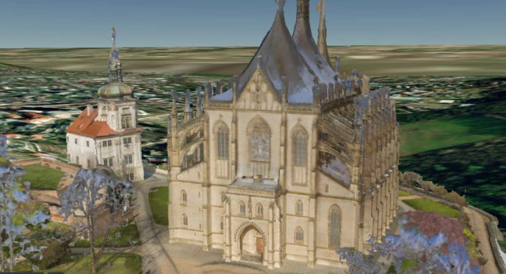
Being able to send hundreds of thousands or even millions of laser pulses per second to collect an incredible amount of accuracy and points allows 360-degree LiDAR sensors to create extremely precise 3D digital models (sometimes called digital twins) of both natural and human-made objects and surfaces of all kinds. The overlapping of LiDAR point clouds with high-resolution images allows 360-degree cameras with LiDAR to achieve a precise, geo-referenced, image-like digital model of pretty much everything around.
Who can make use of LiDAR-integrated 360-degree cameras?
Those who benefit from the unprecedented precision and mobility that 360-degree cameras with LiDAR provide are many, including 3D mapping professionals, construction businesses, asset and maintenance departments, self-driving car companies, authorities involved in landscape and nature protection, the public sector, and many others. The increasing quality of achievable LiDAR data, combined with the progress in photogrammetry and post-data processing methods, has been and will continue to open new doors for a number of applications.
Who can afford a 360-degree camera with LiDAR?
Although we might owe you an apology for a rhetorical question in the title of the paragraph, the costs of LiDAR sensors come hand in hand with the precision of LiDAR-integrated mobile mapping systems. The good news is, though, the cost efficiency is naturally one of the key focus areas of LiDAR mobile scanners designers.
Our favorite Mosaic integrations
Mosaic’s mobile mapping cameras are specifically designed to capture high-resolution 360° images and integrate with external sensors, including GNSS receivers, LiDAR scanners, and INS/IMU units. This modular approach allows you to tailor your team’s equipment setup for enhanced data accuracy and comprehensive spatial analysis.
2025 Update: We are now proud to promote integration with many of our customers’ favorite sensors, including EMLID, Xsens, Riegl, Leica, Trimble, and more. Check out this article for the full scoop.
What types of LiDAR have been shaping 360-degree mobile mapping?
To allow this remote sensing method to meet the specific needs of a particular branch, different types of LiDAR have been developed and integrated with different technologies that vary in their functionality and characteristics, but let’s stick with those involved in mobile mapping for today.
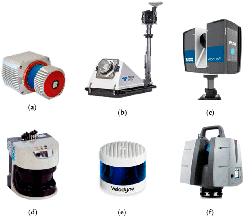
Lidar sensors:
- (a) RIEGL VUX-1HA
- (b) Teledyne-Optech Lynx HS300
- (c) FARO Focus 350
- (d) SICK LMS511
- (e) Velodyne Alpha Puck
- (f) Hexagon-Leica ScanStation P50
Depending on the platform and the inherent scale of the area in which LiDAR data are collected, we differentiate between:
Airborne LiDAR
As the name suggests, an airborne LiDAR unit is mounted to a helicopter or drone, sending laser pulses downwards as it moves, allowing data for 3D point cloud terrain models to be collected (with applications in topographic and bathymetric surveying, forestry, agriculture, and others).
Terrestrial LiDAR
Terrestrial LiDAR systems are involved in applications that require a detailed and precise investigation and record of objects on the ground, at street level, to better capture the horizontal views of objects and the environment, rather than the oblique views from airborne.
- Static LiDAR, usually mounted to a tripod, is applied when a high level of accuracy of the distance of the surrounding environment towards a fixed point is needed (and trust us, the applications of which, e.g., in atmospheric research, would suffice for a separate article).
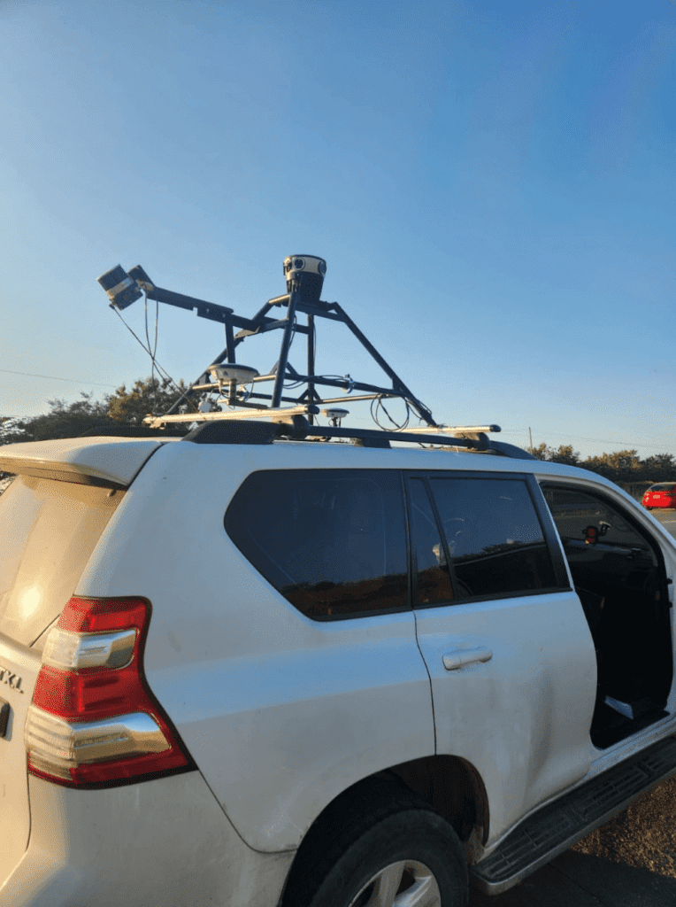
- Mobile LiDAR technologies for mobile mapping, mounted usually to a moving vehicle, (a car but also a train or a boat) allow the scanner to collect point data and create a 3D model of its immediate surroundings while it moves forward in the investigated area. In the case of a 360-degree camera paired with LiDAR, the area of interest is covered by thousands of high-resolution images and point clouds taken by laser scanners, which together form a compact model for measurement and visualization (including the texture information). This is often referred to as ‘colorizing the point cloud.’
So, where should you look and what should you look for when searching for 360-degree LiDAR for mobile mapping?
When trying to find your bearings among 360-degree LiDAR systems for mobile 3D mapping, a lot of variables need to be considered such as scan speed and final image capture, the data quality of the scans at high speed (while a 32-beam LiDAR could be sufficient for a vehicle moving at a speed of 50–60 km/h, for higher speeds, a higher rate of beams is necessary), image quality of the scanner, real-time and post data processing, its capability to cope with demanding weather conditions and many others.
Today, we are going to have a closer look at some of the leading LiDAR companies’ 360-degree mobile mapping solutions.
Velodyne + Ouster = Ouster
Let’s start with some very fresh news: Did you know that Velodyne merged with Ouster recently? They announced the successful completion of their merger of equals, effective February 10, 2023. The LiDAR powerhouse will keep the name Ouster, and we are looking forward to witnessing the LiDAR adoption acceleration it promises. (See the press release)

But let’s get back to 360-degree mobile mapping solutions that Velodyne designed in-house. Thanks to dual return mode, Velodyne lidar sensors deliver a high-resolution surround view image to accurately measure and analyze even very complex environments to build highly accurate 3D models for mobile mapping. Although dual return on the one hand allows promising points per second, it comes with computational complexity on the other hand.
Let us sum up the technical specifications of Velodyne solutions featured for 360-degree mobile mapping.
| Model | Range(m) | Range Accuracy(cm) | Nr.of beams | Horizontal FoV(◦) | Vertical FoV (◦) | Points per s | Refresh rate (Hz) |
| HDL-32E | 100 | +-2 | 32 | 360 | 41.33 | 695000 | 5 to20 |
| Puck | 100 | +-3 | 16 | 360 | 30 | 300000 | 5 to 20 |
| Ultra Puck | 200 | +-3 | 32 | 360 | 40 | 600000 | 5 to 20 |
| Alpha Prime | 245 | +-3 | 128 | 360 | 40 | 2400000 | 5 to 20 |
Lidar mobile mapping with Ouster 3D sensors
One of the key benefits of Ouster 3D sensors in general is the cost advantage of using simultaneous localization and 3D mapping (SLAM) instead of GPS INS systems (The good ones can cost tens of thousands of dollars). SLAM uses the lidar data itself to line things up. Its multi-beam flash lidar design makes it a cost-effective and versatile mobile mapping solution that outputs a comparable number of points. This is what Ouster 360-degree Lidar sensors offer:
| Model | Range(m) | Range Accuracy(cm) | Nr.of beams | Horizontal FoV(◦) | Vertical FoV (◦) | Points per s | Refresh rate (Hz) |
| OS2 -32 | 1-240 | +-2,5 – +-8 | 32 | 360 | 22,5 | 655 000 | 10, 20 |
| OS2 – 64 | 1-240 | +-2,5 – +-8 | 64 | 360 | 22,5 | 1 311 000 | 10, 20 |
| OS2 – 128 | 1-240 | +-2,5 – +-8 | 128 | 360 | 22,5 | 2 621 000 | 10 – 20 |
Heisai on the autonomous mobility mission
Chinese Heisai, which recently reached the milestone of 100,000 delivered units, is the global leader in LiDAR solutions. The company’s LiDAR products enable a broad spectrum of applications, especially across driver assistance systems (ADAS) and autonomous mobility.
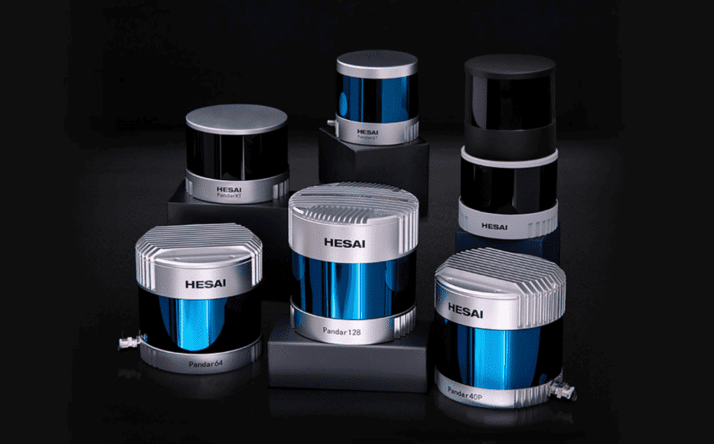
See what technical specifications one can get with some of the LiDAR sensors with 360-degree FoV by Heisai:
| Model | Range(m) | Range Accuracy(cm) | Nr.of beams | Horizon- tal FoV(◦) | Vertical FoV (◦) | Points per s | Refresh rate (Hz) |
| PandarQT | 0,1 – 60 | +-3 | 64 | 360 | 104.2 | 384000 | 10 |
| PandarXT | 0,05 – 120 | +-1 | 32 | 360 | 31 | 640000 | 5,10,20 |
| Oandar40M | 0,3 – 200 | +-5 – +-2 | 40 | 360 | 40 | 720000 | 10,20 |
| Oandar64 | 0,3 – 200 | +-5 – +-2 | 64 | 360 | 40 | 1152000 | 10,20 |
| Pandar128E3X | 0,3 – 200 | +-8 – +-2 | 128 | 360 | 40 | 3456000 | 10,20 |
The house of RIEGL
RIEGL, which many consider the most well-respected LiDAR business, designs terrestrial laser scanners that allow integration with up to four additional cameras and are fully integrated with INS/GNSS, enabling them to collect detailed and highly accurate 3D data rapidly and efficiently. Applications are wide-ranging, including Topography, Mining, As-Built Surveying, Architecture, Archaeology, Monitoring, Civil Engineering, and City Modelling.
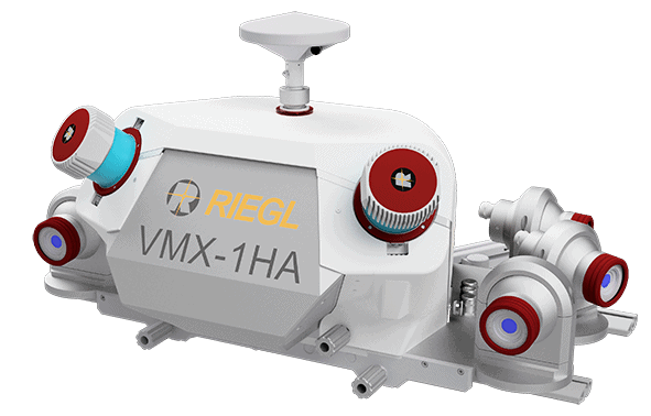
See what there is at hand with some of the Riegl 360-degree LiDAR sensors:
| Model | Range(m) | Range Accuracy(cm) | Nr.of beams | Horizontal FoV(◦) | Vertical FoV (◦) | Scan lines/s | Pulse repetition rate |
| VMY-2 | 1- 270 | 0,1 | na | 360 | na | 250 | 600 kHz |
| VMY-1 | 1- 270 | 0,1 | na | 360 | na | 100 | 300 kHz |
| VMX-2HA | 1,2 – 475 | 0,5 | na | 360 | na | 500 | up to 3.6 MHz |
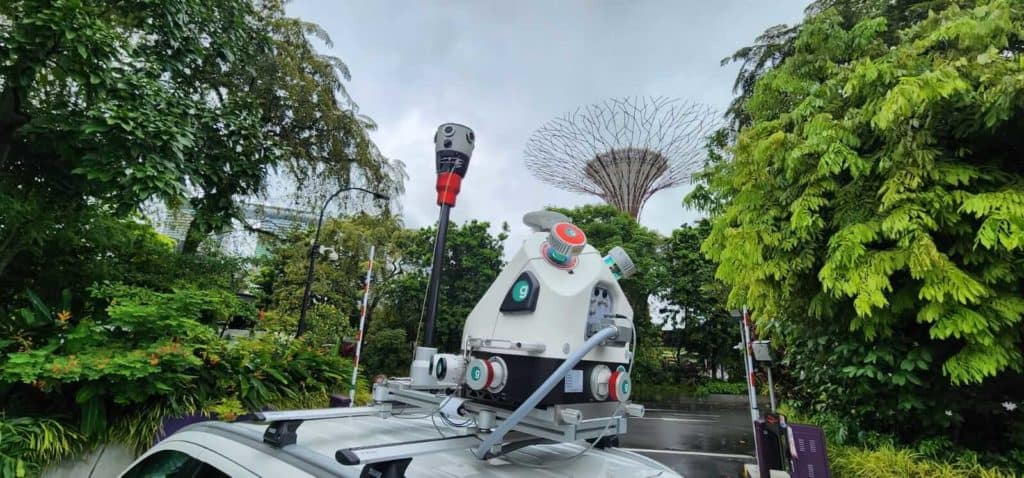
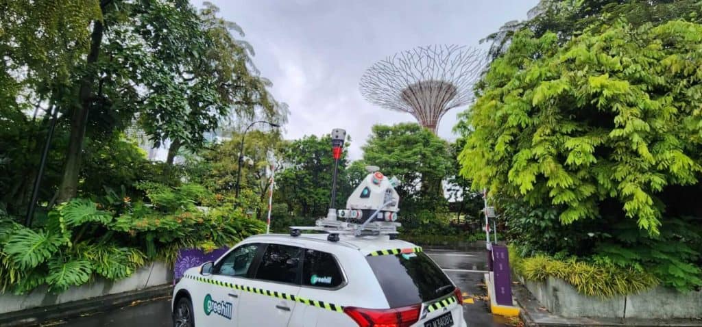
You can learn more about the integration between the RIEGL VMX-2HA and the Mosaic X camera by joint customer greehill here.
When Mosaic met RIEGL
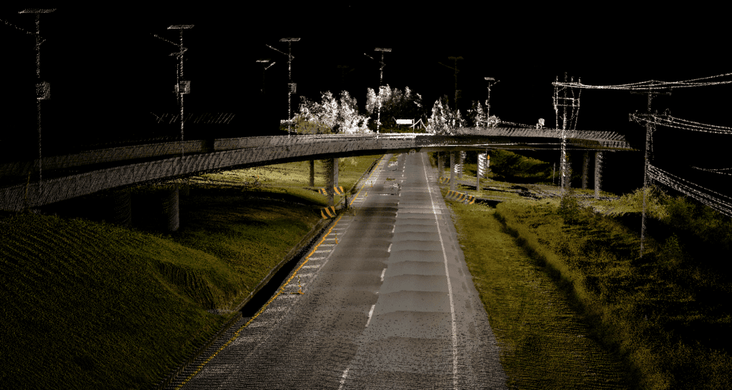
The restless innovation that LiDAR scanners undergo is constantly being refined and increasing both the volume of data that can be used to obtain an increasingly accurate 3D model of the world around us and the speed and accuracy of its collection. Integrating a 360-degree high-resolution camera with Lidar allows an almost real-time creation of both geo-referenced and photorealistic digital twins of even complex environments of a vehicle moving up to 100 km/hour.
Extreme high-resolution 360º-cameras coupled with LiDAR were something that had been lacking in the market for a long time. Until the Mosaic X.
Mosaic X integration with RIEGL V-Line Scanners makes it the highest resolution 360-degree mobile mapping camera featuring a global shutter for photogrammetry ability at highway speeds to be available to users. Being able to integrate with any industry-standard LiDAR scanner for mobile mapping, together with restless innovation efforts at Mosaic, makes a combination that drives Mosaic 360-degree cameras very much forward on their mission to build not only a better but also a high-definition and geo-referenced view of the world.
What camera images + LiDAR mean for users
The coupling of LiDAR and 360º images grants users the benefits of both worlds. On one hand, they get a highly accurate point cloud captured quickly and accurately, which can be used for photogrammetry at scale. This is highly advantageous when precise measurements are needed, and every centimeter and millimeter matters.
On the other hand, the images produce a photorealistic image of what the environment in question really looks like. As many users of the data may be lay people who are unfamiliar with a point cloud or unable to comprehend what a detailed point cloud is showing, images are understandable by anyone who looks at them.
In other words, while LiDAR is very good at capturing extreme accuracy, it can’t do textures. Even the most detailed lidar scan will never look real if it doesn’t have good photographic textures. Neural / AI-enhanced meshes can be believable, but only if they can utilize real photographic textures.
Photos are able to pick up and display details that are not possible with LiDAR, such as graffiti on building walls or stickers on light poles.
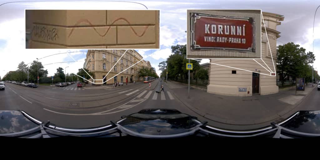
Rust on the transformers and wiring can also not be picked up by LiDAR and necessitates high-definition imagery.
LiDAR increases the accuracy when measuring the cracks in the road surface or the distance of tree growth for Right of Way, and images add an extra dimension that only adds more benefit to the end user.
Looking to acquire a high-resolution 360º mobile mapping camera for use in your LiDAR MMS? Contact us today, and let’s see how we can help you.


