
Knowing which road surfaces and assets need repairing is critical to maintaining a safe and efficient road network. This is especially relevant in the Nordics, where infrastructure is exposed to extreme weather conditions for long periods. As populations grow and more road infrastructure is developed, manual road inspections are no longer practical. That’s where Field’s advanced mobile mapping solution comes in.
(Original article posted by Field Group here.)
Mobile mapping captures geospatial data in the surrounding environment. It uses mobile devices or vehicles equipped with advanced sensors, cameras, and other technology. As the vehicle moves, sensors collect data to create detailed and accurate 3D maps about roads, buildings, bridges, and vegetation, among other features.
Advanced mobile mapping solution
Field’s advanced mobile mapping solution comprises FieldRoadTM, the Mosaic X camera, and Mapspace.
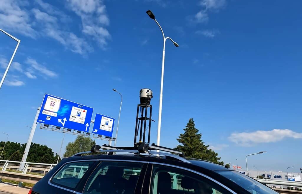
A cloud-based service offering ultra-high-resolution and geographically accurate street-level imagery, FieldRoadTM combines the Mosaic X camera with in-house developed calibration and processing to create highly detailed and accurate 360-degree panorama images.
These processed images are then uploaded to Field’s geospatial viewer, Mapspace. Here, customers can explore, interrogate, and export the images, revealing precise insight into their road assets.
In developing the most recent iteration of the Mosaic X camera, Field participated in the prototype testing stage. They were the first to receive the camera prototype for extensive real-world testing before it was ready for full-scale production. Field’s team of mobile mapping experts put the camera through rigorous trials across Norway’s road networks during an entire season of data capture. With their feedback, Mosaic fine-tuned the product.
The outcome is a durable camera that boasts user-friendly operation, seamless integration into Field’s mobile mapping system and processing routines, and the highest-quality imagery. The increased image quality means that it is possible to see more details along roads and within the cities, and it is easier to pinpoint and locate areas of interest, such as light poles, bolts on infrastructure, and rust on signs.
Proven accuracy supports sustainable road maintenance
The successful collaboration between Field and Mosaic means road asset managers and owners can now explore and interrogate data in significantly more detail. This reduces the need for field work, explains Field Product Manager Kim Willem van Woensel Kooy.
“We’ve got the formula right. Supported by great camera hardware, our highly detailed and accurate road documentation and condition analysis help road administrators understand their infrastructure assets and prioritize resources for more sustainable and safe road maintenance.
“Only a few years ago, we were far from achieving this level of detail and accuracy. It’s exciting to see the technical evolution, and we’re receiving great feedback from our customers,” he said.
Recent analysis into the accuracy of Field’s road asset inspection solution revealed that Field’s continued efforts to integrate and calibrate the Mosaic X with mobile mapping laser scanners paid off. By deploying calibrated images and point clouds to Mapspace, the Field processing team compared measurements done in the viewer to real-world measurements provided by Field land surveyors. After measurement comparisons, the result shows an average absolute accuracy of 5 cm horizontally and 7 cm vertically. With this accuracy, Field’s Mapspace can significantly reduce the need for fieldwork.
The line of Mosaic mobile mapping cameras was designed to redefine image quality standards in the mobile mapping industry, explains Mosaic’s Director of Sales & Marketing, Lynn Puzzo. Mosaic cameras can also easily integrate with larger mobile mapping systems and deliver non-vendor-locked data. This means that users, such as Field, can craft a system and workflow that best suits their needs.
“It has been a pleasure working with Field. Their surveying know-how and large-scale projects have allowed us to test the limits of our cameras’ technology and durability beyond our own capabilities.
“Their confidence in us from the early stages of development has enabled us to grow and deliver newer, customer-focused hardware that meets their needs and expectations,” said Puzzo.
Explore the road network 360-viewer
View and pan road network images with Field’s interactive Mapspace 360-viewer below.
To explore full capabilities, contact Kim Willem van Woensel Kooy to schedule a Mapspace demonstration.
To learn more about the collaboration over the years between Field and Mosaic, check out one of these articles:
Get in touch
Kim Willem van Woensel Kooy
Field Product Manager; email: [email protected]
Lynn Puzzo
Mosaic Director of Sales & Marketing, email: [email protected]


