
How is it possible to get large-scale 3D models and reconstructions of outdoor environments using photogrammetry and not LiDAR? Follow us!
Large-scale photogrammetry is essential in many fields such as surveying land, plants, warehouses, real estate, construction, mining, and many more. It can help visualize the environment, allowing maps, 3D models, and reconstructions to aid in decision-making.
When 3D models are utilized for commercial purposes, they can provide more information to potential buyers or tenants. This leads to quicker decisions and better deals. 3D models of building exteriors are also helpful for architects who want more visually appealing renderings before investing in more expensive materials.
But creating large-scale 3D models of huge outdoor facilities and environments, such as a business park, an entire neighborhood, or a new development, can be extremely time-consuming and labor-intensive, which, of course, requires a substantial budget.
Discover more about the options for commercial real estate firms, construction companies, architectural firms, and governments that need to present realistic visualizations of their visions to clients, investors, or committees when planning new projects or evaluating current ones.
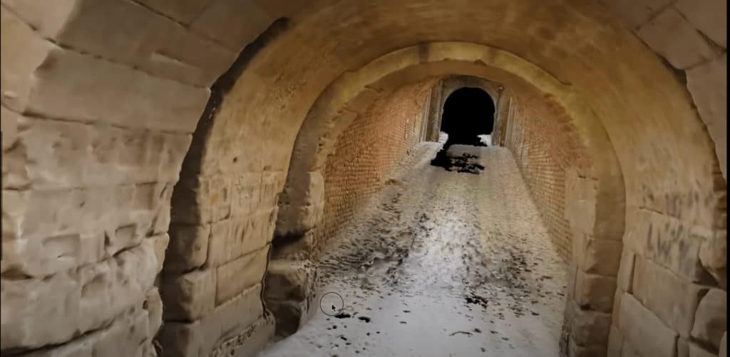
STICK AROUND TILL THE END TO SEE AN INCREDIBLE 3D MODEL CAPTURED IN UNDER 1 MINUTE!
3D modeling of building exteriors
Three-dimensional models come in a whole assortment of flavors. Every Matchbox car is a 3D model of a real car; a toy doll or action figure is a 3D model of a person (however unrealistic the proportions might be). You can have a 3D model of a statue or landmark in the form of a souvenir from your last trip. Museums often house mini 3D replicas of entire towns or battle scenes. And now many digital artists and software programs can create virtual 3D models of superheroes, monsters, and whole environments with a few (thousand) clicks of their mouse for video games, movies, and VR experiences.
For our cases today, we are going to be focusing on digital 3D modeling of infrastructure, such as homes, office buildings, apartment complexes, and public spaces. And we are going to be focusing on exterior spaces, including all exterior walls, surrounding green spaces, driveways, parking lots, landscaping, etc.
Creating 3D renderings of large-scale building sites, infrastructure projects, and commercial sites is necessary to maintain a constant watchful eye on the current state of the buildings in question. Whether the project is in the midst of being built or has been around for decades (or even centuries), it is necessary to keep an eye on the status and the state of things.
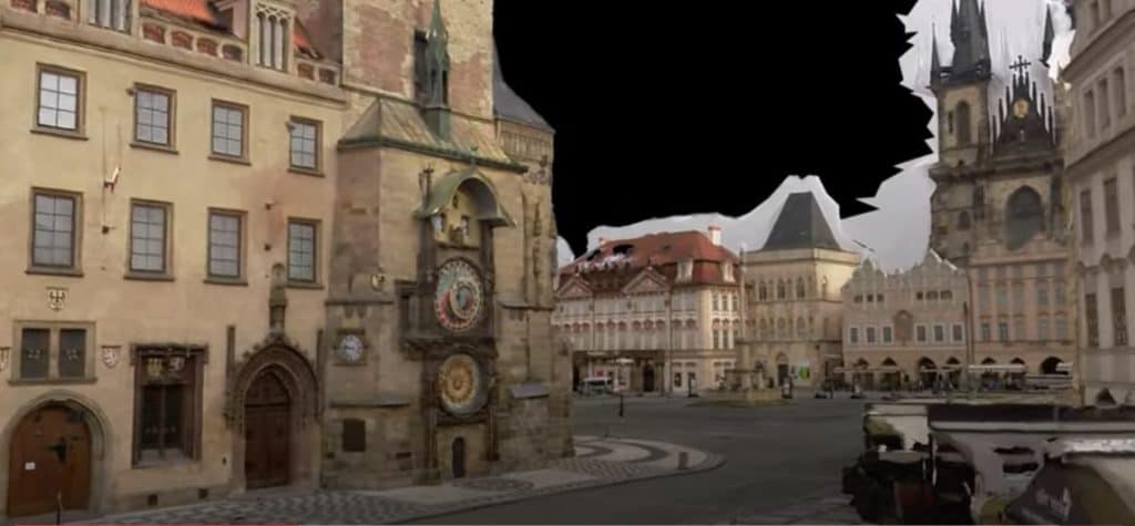
The 3D aspect gives all those involved a better handle on the actual situation of events, as they can often move around the buildings, as if they were really there, zooming in and out at particular locations, as the video above shows.
Benefits of 3D models for commercial real estate companies
When used for commercial real estate, 3D models can provide a more realistic view of the property for potential buyers or tenants. This is especially important for larger or more complicated buildings where traditional 2D photography may not be able to capture all the details and truly leave an impression on the viewer.
- Get a truer-to-life experience by being able to see what the building looks like from different angles and distances
- Reduce the need for site visits by anyone involved in the decision-making process, building, selling, or buying. Virtual visits from the latest gathered data, portrayed in a 3d model, means not having to repeatedly return to the physical site in order to understand the status of the project
- Eliminate visits altogether. Real estate agents and sellers do not have to visit the actual site in order to know the property that they are working to sell. This is especially useful when multiple buyers are considering the same property. In fact, real estate agents reported a nearly 500% increase in agent-led 3D tours in the last 2 years.
- Increase the efficiency of viewing multiple properties once. Buyers do not have to travel from site to site, house to house, wasting precious time to see multiple locations. While not quite as shocking as the above number, there was a slight uptick in the number of people buying houses in the U.S. without ever setting foot in them, thanks to 3D models that allowed them to tour the house before buying.
See for yourself how Mosaic can help with our 360-degree mobile mapping cameras for real estate companies.
Benefits of 3D models for architectural firms
3D models of building exteriors are also helpful for architects and engineering firms.
- Show more visually appealing renderings before investing in more expensive materials.
- Visualize how different materials will look on a building and whether or not they will be happy with the final result. Models provide information on lighting, materials, colors, textures, and other unique features of a proposed design. With these visualizations available to an architect prior to construction, challenges can be identified without investing in expensive materials first or waiting until later on in the process to identify issues with designs.
Discover more about how Mosaic can help with our 360-degree mobile mapping cameras for architecture and engineering firms.
Benefits of 3D models for governments and municipalities
Local governments and municipalities are also able to take advantage of 3D models and 3D maps, some going so far as to create digital twins of their towns and cities.
- Get an accurate representation of the current state of the environment
- Understand how spaces are used by local residents as you are able to move around within the 3D model yourself
- Create virtual tour spaces for potential investors and committees when debating future projects, maintenance, and updates
Discover more about local governments and central governments’ use of geospatial technology, such as 360-degree mobile mapping cameras, here.
How do you create a 3D model of a building’s exterior?
So let’s get down to it. How are 3D models and 3D reconstructions of large outdoor spaces created? There are several methods for creating 3D models. We’re going to take a look at several methods that have been used in the past and the newest technology on the market for creating large-scale 3D models.
3D models from Sketches or Direct Inspection
Some 3D models start with sketches, whether hand-drawn or sketched within a software program. The artists might gather this information from photos or site visits. Rather than having to do everything by hand. However, software programs make it easier to fill in the details and modify as needed.
The process of creating a 3D model generally starts with creating a plan or sketch of the building. Once you have a basic outline of the building, you can start adding in more details. This might include adding in the dimensions of each room, creating walls and doorways, and adding in furniture and other props. You can also add textures and lighting to make your 3D model look more life-like.
3D models from Photogrammetry
Photogrammetry is the science of making measurements from photographs. It is used in a variety of fields, including surveying, mapping, 3D printing, and forensics. Photogrammetry can be used to create a scale model of an object or scene from a series of photographs.
One common use of photogrammetry is to create a 3D model of an object. This can be used for a variety of purposes, such as creating a 3D replica of the object or using it for forensic analysis. To create a 3D model from photographs, the photos must first be stitched together in software that calculates the position of each point in the photograph. This information is then used to create a three-dimensional model of the object.
Photogrammetry can also be used to create maps and surveys. By taking a series of photographs from different angles, it is possible to create a detailed 3D map or 3D model of an area. This can be useful for tasks such as land surveying or mapping out archaeological sites.
Photogrammetry is also fairly easy in terms of the basic setup and delivery. Any camera, a standard DSLR or a smartphone ,can be used to capture the images needed to input into the photogrammetry software. Due to this, it is a fairly low barrier to entry, involving the low costs and relatively low skill level needed for the average job.
3D Models from LiDAR and Point Clouds
Traditionally, in order to create large-scale photogrammetry, it has been necessary to use LiDAR, whether terrestrial (taken from moving or stationary LiDAR devices) or aerial (taken with drones or even aircraft).
LiDAR (laser imaging, detection, and ranging) is a remote sensing method that acts as a special type of 3D camera, telling you exactly how far away every pixel within an image is from the viewer. LiDAR produces point clouds, which are a set of data points in three-dimensional space. It is often used to represent the shape of an object or scene.
Point clouds can be created from LiDAR data, which is collected by bouncing laser beams off objects and measuring the time it takes for the beams to return. The resulting data points can be used to create a three-dimensional model of the object or scene.
Downsides to these 3D modeling methods
- Direct inspection: difficult, dangerous, and time-consuming. This often requires multiple site visits, sites which may require the inspector to undertake a dangerous viewpoint in order to capture the desired view.
- Photogrammetry: low resolution, objects being cut off, and stitching errors. Photogrammetry for large-scale projects, a digital camera or smartphone would be almost unbearable with the hundreds, if not thousands, of photos taken at multiple angles. And if there is not enough overlap in the photos, the post-processing software will cause a number
- of stitching errors.
- LiDAR: precise, expensive, data-heavy, and impractical. LiDAR devices tend to be extremely expensive, meaning the barrier to entry is quite high. Aerial LiDAR is even more expensive, impractical for many customers, and often not precise enough. Also, LiDAR presents data in the aforementioned point clouds, which is not a photo-realistic visualization of the environment.
3D Models at Scale with Mobile Mapping & Photogrammetry
What if we told you that it’s possible to take the advantages of several of these above-mentioned technologies and eliminate most of the disadvantages? Can we give you a solution that can create a 3D model with true-to-life imagery, is more efficient, less labor-intensive, and has a lower barrier to entry?
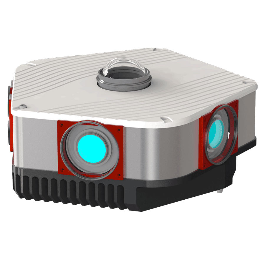
Mosaic has developed mobile mapping cameras that are capable of just that – large-scale photogrammetry without LiDAR.
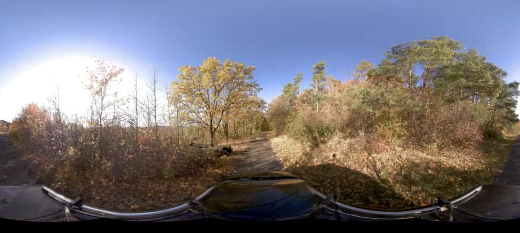
While common photogrammetry methods involve stationary cameras, there is a way to speed up the process and get things moving – literally! Mobile mapping is a process that involves a mobile mapping device mounted on a moving vehicle. It is usually a 360-degree camera with or without several GNSS devices attached.
The vehicle can navigate itself among the space that needs to be captured and collect data throughout the drive. This data can be stored as individual photographs or video streams. Then, modelers can create a 3D reconstruction or 3D model.
Rather than having to take multiple photos from different angles of the same object, the mobile mapping system captures everything simply by cruising down the road. This significantly reduces the normal time needed to capture this amount of data.
3D mapping that imitates life
On top of that, the data captured is true-to-life. So for real estate companies and architectural firms that need to show clients or even their internal team the conditions of a large-scale swath of land, they can do so knowing they aren’t leaving out any details.
Due to the incredibly high-quality images captured with Mosaic camera systems, mapping companies are able to create 3D models, reconstructions, and photogrammetric mapping without the need for expensive LiDAR systems.
You get the visual details of every feature of the environment, with fine-detailed surfaces and features. LiDAR, on the other hand, can be unspecific, offering only point clouds which can be abstract for the average user.
Photogrammetry is significantly cheaper than LiDAR technology, making it more affordable for new entrants into the mapping market, among others.
Setting up and taking measurements with LiDAR can be complicated and often requires skilled experts. And the post-processing also requires a great deal of in-house effort and expertise. Using photogrammetry software such as Reality Capture is fairly straightforward and easy to use.
In addition, many believe that LiDAR is superior to photogrammetric surveying if you’re surveying land with dense vegetation. However, the image that we are able to capture with our mobile mapping systems yields images of vegetation that are highly accurate and robust.
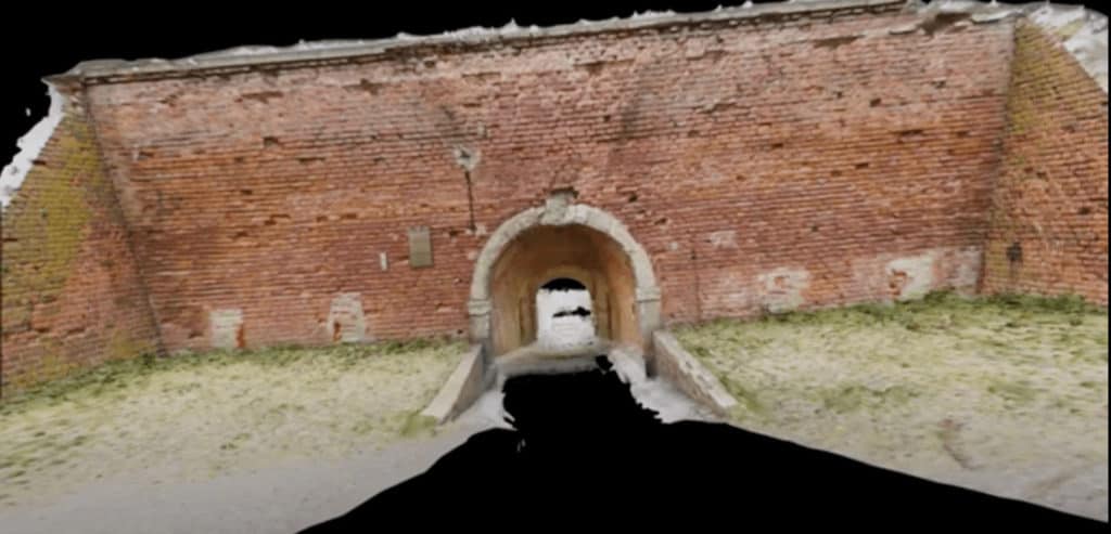
The Final Act: Large-scale Photogrammetry in Action
And as promised, here is a 3D model of a tunnel in Terezin. The whole shot you are witnessing took less than 1 minute to capture – 50 seconds to be exact. The Mosaic Viking (pictured above) captured this imagery. It is a beast of a camera: 6x31MP sensors for 186 megapixels of images, 5 frames per second. 10M Colored vertices, not textured, and most importantly, NO LIDAR!
If you are a real estate company, an architectural company, or a local municipality that needs to capture large amounts of data to create a 3D model, then you’re in luck. Contact the Mosaic team so that we can discuss ways in which we can help you quickly gather data to get you on your way to an extremely high-resolution 3D model of your project.
We look forward to hearing from you.


