
Whether conducting a land or cadastral survey for a homeowner, a construction site, an entire town or township, see why a mobile mapping camera can help you collect quicker and more precisely than ever before
What is cadastral surveying (aka land surveying)?
In the simplest terms, cadastral surveying is accurately measuring and mapping parcels of land and its associated features.
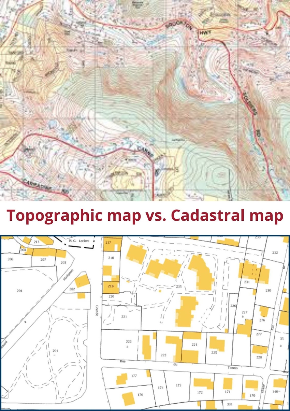
The primary purpose of a cadastral map is to create a map showing the boundaries of individual parcels of land. This includes the location of any existing structures, such as buildings, barns, or other structures.
In addition to the basic marks of a legal land description, such as bearings and distances between boundary monuments, cadastral surveys indicate how much area each parcel of real estate represents in acres or square feet.
History of cadastral surveying and mapping
For the history nerds and language enthusiastic among us, a quick history of the etymology of the term:
The term “cadastre” comes from Late Latin “capitastrum”, meaning “a register of heads” (of livestock).
cadastre /ˈkædəstr̩/: The original record from which all other surveys were copied; specifically, a compilation of actual survey data.

Features included on a land map and cadastral map
The details on a cadastral map vary between countries (in the US, between states) depending upon land registration laws. In countries where registration is not compulsory, a complete record of all properties will not be shown on the map. These are some of the requirements for cadastral maps from around the world:
- the name of the original owner
- nature of its boundaries
- area in acres and fractions of an acre
- number of acres surveyed
- building permits
- zoning regulations
- tax assessments
- street names
- limits of easements
- distance from each corner to permanent monuments* or other corners
- bearing for each line between corners
- names of adjoining owners & their tract numbers
- legal subdivisions of land
*Monuments can be either natural or artificial. Natural monuments include trees, large boulders, etc. Artificial monuments include items that were placed there by people (the land owners, engineers, construction workers, etc.) These include stakes, concrete structures, pipes and anything else determined to be important for this purpose.
What a cadastral surveying map is NOT
A cadastral map is NOT the same as a topographical map as it does not possess qualities. A tile that represents only part of an orthophoto with some additional information (e.g., contour lines) by georeference or reference to the external coordinate system is not considered a cadastral map.
Purposes of a cadastral map / land registry
A legal description based on a cadastral survey has several purposes. Most often, courts use it to settle disputes or clarify land ownership of an area. This is usually due to land divisions over time among families or neighbors, which create confusion in the precise location of land boundaries.
Here is a list of specific use cases for cadastral maps and land registries
- ownership conveyancing (real estate sales)
- insurance claims
- litigation settlement purposes
- provide details about these parcels
- specify their location
- determine their legal status
- establish ownership rights
- estimate their value for taxation purposes
- compute rental values etc.
Who creates cadastral maps / land registry maps
Licensed land surveyors often perform cadastral mapping. Licensed land surveyors must meet certain qualifications, including successfully completing an accredited land surveying program and years of experience. In addition, they must pass a rigorous exam administered by their state licensing board.
What training do cadastral surveyors require?
Individuals interested in becoming cadastral surveyors must be graduates of a university degree course in surveying. They should also have at least five years of work experience, followed by training that includes courses on boundary law and practices; planning and supervision; working with aerial photography; electronic data processing etc.
What is the role of a cadastral surveyor?
The work of a land registry surveyor involves taking measurements of angles and distances on the ground, computing areas, plotting boundaries and entering all this data into a computer. This produces a digital map of the area. He or she must also be familiar with legal principles governing boundary location and adjoining landowners’ rights. As technology advances, cadastral surveyors are increasingly using aerial photography and other remote sensing techniques.
What tools are necessary for cadastral surveying?
Land surveyors use a variety of tools and techniques to accurately determine the location of property boundaries. These include:
- traditional survey methods such as compass and chain
- 3D laser scanning
- Total Stations
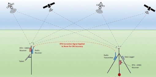
- global positioning systems (GPS)
- Real-Time Kinematic (RTK) positioning – combining at least two GPS receivers—a base receiver and one or more rover receivers (see above)
Learn more about GPS accuracy in our 2 part series: Part I covers accuracy and GPS drift, while Part II covers other alternatives to GPS.
Traditional survey methods are still used today in many cases, especially in rural areas where there is no access to GPS or other modern technologies. The use of GPS and 3D laser scanning has become more common in recent years due to the increased accuracy and efficiency they offer.
What are some problems facing cadastral surveyors?
Cadastral surveying is a critical component of the land management process. By accurately mapping the location of property boundaries, cadastral surveys help ensure that parcels of land are properly identified and managed. This in turn helps to protect the interests of landowners and encourages responsible development.
Which is why some of the challenges and issues facing cadastral surveying have the potential to severely and negatively affect the local landowners, local governments and the communities at large.
Here are just a few of the problems in the fields of cadastral surveying and land registry:
- Inconsistencies in surveys across time due to who is conducting the survey:
Under ideal circumstances the same surveyor would carry out both the initial survey and the resurvey. However this may not always be possible, thus creating problems when using old surveys. - Poor archiving of cadastral information:
Many land surveys are stored on paper and therefore make them harder to access, can easily get lost, and accessible to the public - Lack of money and time for proper training:
Training with new technology can be quite complicated, time consuming and expensive – requiring significant time and money for the local government or institute conducting the surveys.
This is most apparent in poorer nations, making it difficult for them to create or maintain cadastral maps. - Lack of competition:
Until very recently, land surveying was almost universally conducted by the local and regional governments. This brings unfair competition and deters the growth of the private secretary and improvements to the system - Inadequate government support and high turnover rates
Within the workforce, it is common for high turnover rates, creating a lack of continuity in the field, leading to general difficulties in training new surveyors and general quality control problems. - Demand for time
The need for accurate measurements often results in delays, as surveyors have to take great care to ensure that all measurements are correct. - Improper use of technology
While technology has been implemented in many locations, the inaccurate use of it can also create problems, as was seen in India in 2001 when an error in a satellite image led to the subdivision of land belonging to the Tirumala Venkateswara Temple.
How can technology improve cadastral and land surveying?
The field of cadastral surveying is facing a number of challenges at the moment, but there are also many new solutions that could be implemented in order to improve the profession. By working together, the various organizations involved in this field can overcome many of the problems that have been hindering its progress. With better technology and more accurate data, cadastral surveying can become a more efficient and productive field, benefiting everyone involved.
- Greater use of coordinate geometry in geodetic surveying.
- Better integration between land records and geographical information systems (GIS), both for creation and updating of the cadastral records.
- Increased use of cadastral GIS, combining, for example, laser scanning and mobile GPS equipment to collect exact coordinates for property lines and boundaries which can be digitized into a GIS map.
- The creation of digital networks within different countries, allowing for more coordination between practices and easier sharing of data among professionals, governments, and organizations involved with land records offices.
- Modernization of cadastral surveys through the use of satellite and airborne remote sensing in order to acquire and process high-resolution imagery.
- The implementation of more precise datums in geodetic surveying in order to comply with new global standards for geographic information exchange, such as WGS 84 (which is already being used by some governments).
- More widespread computerization and digitization of cadastral data, which would allow for easier storage, retrieval, and analysis.
Using mobile mapping cameras to assist in cadastral surveying
One such technology that could greatly help aid in the improved quality of cadastral surveys is 360-degree mobile mapping cameras, either as a part of a mobile mapping system, or as a stand alone device. While most of the advantages mentioned above focus on GIS (which is a software), digitization, integration and more, we first need hardware to gather the data before we input it into any of the intricate, analytic systems.
What is a mobile mapping camera / system?
A mobile mapping camera and/or system (MMS) is a piece of hardware which is typically mounted on a moving vehicle and is driven around (by a human, but in the future we think there will be many more autonomous vehicles doing this work).
A mobile mapping system can be equipped with a variety of sensors, such as GPS receivers for positioning, digital compasses to determine the direction, a lidar scanner for three-dimensional object detection and a camera to register images.
In addition, various measuring devices are used to collect data about objects that are inaccessible or expensive to measure in another way. The integration of various sensors connected wirelessly in real time enables an efficient collection of geoinformation in almost all ecological zones.
Some or all of the following pieces of hardware may be included in a MMS:
- LiDAR (laser scanner)
- electronic distance meter (EDM)
- digital camera
- 360-degree camera
- GPS receiver and antenna
- inertial data collector and accelerometer
The data acquired by sensors can be processed on board the device or transferred via telemetry network to a central base station where it can be further processed using different systems depending on the customer’s needs.
Applications of a mobile mapping system
Mobile Mapping Systems are used, for example, in the following application areas:
- cadastral surveying and cartography
- land management and land administration
- 3D city modeling and monitoring
- engineering surveys (including construction control)
- archaeological prospecting
- forestry
- nature conservation
For a whole list of industries and sectors that benefit from mobile mapping cameras and systems, check out here.
How a mobile mapping camera can help with cadastral surveying
A mobile mapping camera, like the Mosaic 51, can significantly increase the accuracy and precision of the data collected for cadastral surveying, as well as increase the efficiency in the data collection process. Here’s how:
- Data can be collected much quicker than traditional methods, at driving speeds
- There is no need to shut down roads or divert traffic during surveys, thus saving money for the surveyors and stress and time for drivers
- With its IP67 rating it is possible to operate safely in heavy winds, rain storms and through extreme heat
- It is easy to operate a mobile mapping camera, especially the M51, as it is an all-in-one, plug-and-play solution with no training necessary
- Easy operation means less expenses for training surveyors and increases who can conduct a survey
- Can collect image data at 12K resolution for extreme definition, allowing for more information to be know about the location
- It is easier to update information and compare against previous surveys, with HD images
- Data is more uniform, unlike when individual surveyors report different finds based on their preferences
- The auxiliary port allows up to 4 GNSS devices to be connected to ensure millimeter-level accuracy for proper measuring
One study found that the use of a mobile mapping system decreased the number of people necessary as well as the time involved for conducting a survey. Their results were as such:
- RTK requires 60 people days / 1km2
- MMS requires 20 people days / 1km2
So if you’re in cadastral surveying and are looking for a faster, cheaper, more accurate way to collect and produce a cadastral map, have a look at the line of Mosaic mobile mapping cameras.
If you have any questions, don’t hesitate to reach out to us either.


